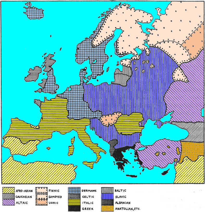
CHAPTER SEVEN — SLAVIC EXPANSION
 Background
At about the same time that Roman power was beginning to wane, a new ethnic movement was getting
underway in eastern Europe. This was the expansion of Slavic-speaking peoples that has been back-tracked in time and space, by most authorities, to
about 200 AD somewhere in the middle Carpathian region. Unlike the influence of Rome, this event
was not based on higher level of civilization, nor on any particular military capacity.
Sheer numbers are all that can be found to explain this movement that constituted an irresistible
flood for many centuries.
Estimates of population density for most of eastern Europe at 200 AD center on around two per sq
km, a figure far lower than in all regions to the south and west. This is largely a consequence of
the smaller fraction of the land that is suitable for plowing. This density must be multiplied by
about four times in order to create the kind of population pressure that would have enabled the
Slavs to overrun most of their neighbors, many of whom had equal or higher levels of civilization. Great increases in population are made
possible only by corresponding increases in food production. In the 6000 years that farmers had
occupied this area, population density had only doubled from the presumed initial figure of one per
sq km. A major change in the agricultural base at this time and place could easily have been
postulated even if we did not have any direct knowledge to that f effect. In this case we do know.
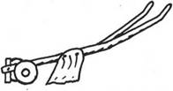
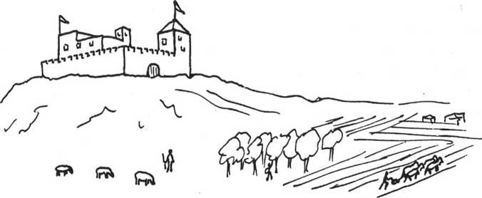
Before this time the simple scratch plow, or aratum, was the only type in use. This
plow was pulled by a pair of oxen and just cut a furrow in the ground. It could not be used in
deep turf or heavy clay soils. The mold-board plow, also called the caruca or simply the heavy
plow, was a much more complicated machine. It begins with a vertical knife supported at the
front to cut the turf. This is followed by a horizontal plowshare,
set well below the ground surface, to which is attached a curved board that lifts the topsoil and
turns it over. It has wheels to support its weight and to set the depth at which it plows. This
whole apparatus is then pulled through heavy soil by a team of usually eight oxen. Fields mostly
changed in shape from squares to long rectangles so that fewer turns had to be made with this
cumbersome affair. (See White 1962.)
An obvious place for such a plow to be developed would be near the edge of the Hungarian Plain where
the soil could not be tilled with the light plow. In this area there was a meeting of Roman
technology with that of immigrant Celtics, as well as that of local forest and steppe peoples. If
this innovation was developed along the northeastern margin of Magyar territory, then the subsequent
ethnic movements would automatically follow just as recorded.
|
A little etymology may go a long way to help understand historical interconnections. The English
plough/plow and Slavic plugu/plug are derived from Latin plovus/plovum “plow”,
according to Pliny (before 70 AD) of Rhaetian, or ultimately of non-IE Etruscan origin. Cognates: Old English
plog, ploh, Old Saxon plog, Old Frisian ploch, Middle Low German ploch,
Middle Dutch ploech, Dutch ploeg, Old High German pfluog, German Pflug;
Old Church Slavonic plugu, Lithuanian plugas. The word refers to wheeled heavy plough
known from 5th century AD in Roman northwestern Europe, centuries before the purported invention on
the edge of Hungary. This was an obviously a Roman technology.
Another term for plow was Old English
sulh “scratch plow, ard”, with Balto-Slavic cognates Lith. shaka, Latv. saka, Slav. sokha
“scratch plow, forked branch, forked post”, with source in Balto-Slavic; the Latin cognate is
sulcus “furrow”. These terms are for primitive scratch plow.
And another English term for plow was ard,
Old Norse arðr, Swedish årder; its Slavic counterpart is oral/oralo, derived from Türkic ara
“fang (carnivorous)”; the Germanic word with no IE etymology derives from the Scytho-Sarmatian
lexicon. These terms are for primitive scratch plow.
The bottom line: neither Magyars, nor Slavs came up with a mold-board plough; neither Slavs had
terms for metalworking, the Slavic terms for iron and pig iron are late borrowings
from Türkic, centuries (or millennium) after Türkic people brought metalworking to the Balto-Slavs:
jelezo and chugun respectively. The sokha scratch plow remained the Slavic plow
to the 18th c., when metal-tipped plows became available from the metalworks in the annexed Urals.
|
Most of the soil of Europe, outside of the Mediterranean area, was too heavy for the light plow and
remained untilled up to this time. Lighter soils in the upland forests, as well as alluvial river
valleys, were abundant enough that farmers were previously able to effectively occupy the whole
area, but only at a low population density. When the heavy plow became generally
available far more of the land could be tilled — possibly four times as much in most places. This
provided the basis for a population explosion that radiated from the source.
136
 Beginning Expansion
The rate of expansion of plow agriculture through the Hungarian Plain itself is a bit difficult to
calculate. For the most part, this territory was now being farmed for the first time.
Most of the plain was cattle and horse country, but it included some river-valley agriculture, and
was surrounded by farmers no more than 100 km from any point within. General farming skills, hired
hands, seed, and a planting calendar were easily obtainable, so the advance was probably much faster
than the original expansion of simple farming. My suggestion is that a double speed, equal to that
of expanding pastoralists, would be applicable here. At this rate 150 years would see this deep-soil
farming spread from its source point through about half of the Hungarian Plain. Another 150 years
would take it through the rest of the plain to the southwest, and well out into the surrounding
forested lands. Magyar expansion in all other directions would be quite different. (See Figs.
22, 23, and 24 for maps of ethnic spreads caused by the mold-board plow.)
|
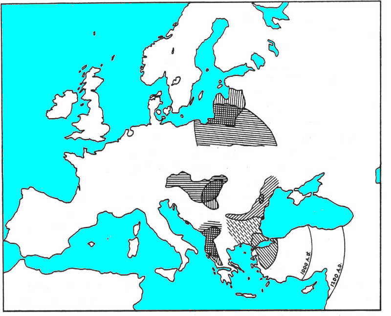
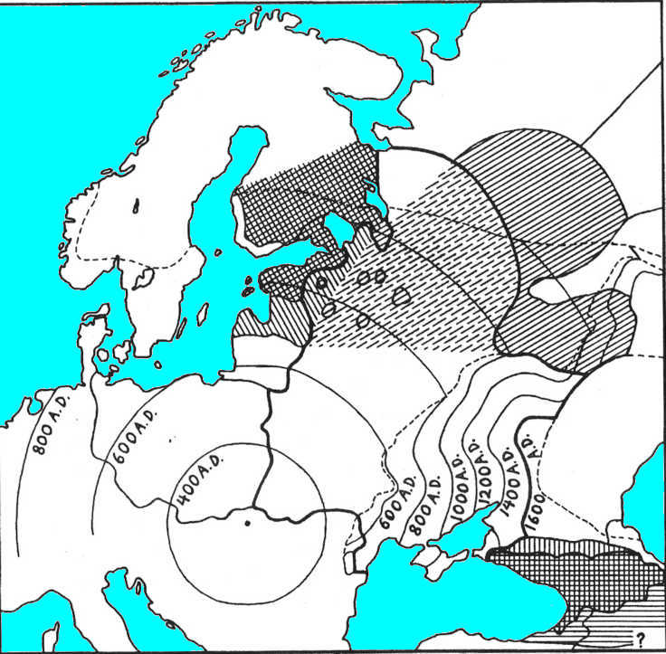
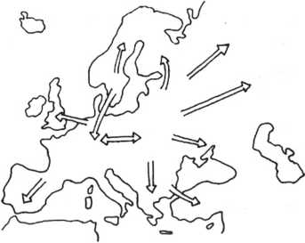
Fig. 22. Slavic expansion. This is the first of four maps showing ethnic shifts that followed
from the development of the mold-board plow. The original Slavic area is the unbordered circle of
cross-hatching around the dark spot that marks the plow's origin. Slavic expansion is shown by
groups of parallel lines radiating in three directions for the western, southern, and eastern
branches. A small area near the center was lost to expanding Magyars. The date is 800 AD when the
western and southern advances have halted, but the eastern is still progressing. Eastern limits at
1000 and 1200 AD are also indicated. The 800 AD line in the west marks the probable position of
heavy plow technology among the local, non-Slavic peoples. |
 |
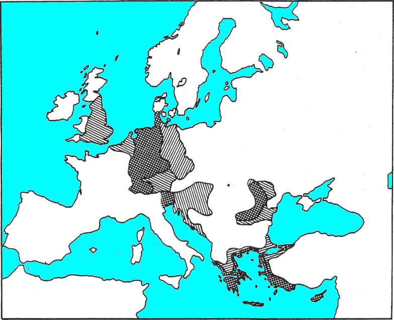
Fig. 23. Non-Slavic expansions, Group I. These four languages show changes that resulted from use
of the mold-board plow.
Their positions alternate with others (Figs.
22 and 24) to separate their overlapping movements. For
each language, lost territory is marked with "defensive" lines perpendicular to the direction of
plow advance, retained area is cross-hatched, and gains are lined parallel to the direction of
advance. In the north, Baltics lose ground to Slavics, hold Lithuania, and gain Latvia before
passing the plow on to the next people. Magyars lose their southern tip and gain much to the west.
Albanians lose and gain modest amounts. Turkic loses most of its Balkan holdings (the northeastern
border is left vague here) and expands into Anatolia. These Turks first gain, and then lose, the
dashed area of Bulgaria. The map is dated at 800 AD, and shows lines of 1000 AD and 1200 AD
for the Turks in Anatolia. |
 |
|
Fig. 24. Non-Slavic expansions, Group II. These four languages show changes that resulted from use
of the mold-board plow.
Their positions are alternated with others (Figs.
22 and 23) to separate their overlapping
movements. Use of the plow spreads in four directions from the origin spot. For each language, lost
territory is marked with "defensive" lines perpendicular to the direction of plow advance, retained
area is cross-hatched, and gains are lined parallel to the direction of advance. In the west,
Germanics lose a wide strip on their east and gain greatly in Bavaria, the Low Countries, and
England. Romans lose old Pannonia, Croatia, and Dalmatia, but hold in Italy proper.
Greeks lose most of their inland area. Romans in Dacia spread considerably to the east. The map is
drawn at maximum expansion of the peoples involved, about 800 AD |
 |
Modern Hungarian speech extends about 40 km beyond the plain to the north and north-east (Fig. 23).
This suggests that the heavy plow was developed inside Magyar territory, and that the new farmers
expanded in these directions as well. Given the novelty of serious farming, and the proximity of the
Slavic frontier, the Magyars would not have built up any significant population pressure in this
direction. Adoption of the plow by Slavic farmers would have been rapid — they may have devised much
of it already.
137, 138
The fact that almost all of the terminology relating to the mold-board plow and its parts is of
Slavic origin (is it really? The whole concept rests on Slavic origin of
the mold-board plow terminology that the old Pliny ascribed to Rhaetians or ultimately Etruscans
before the 70 AD?) forcibly suggests they are its inventors (White 1962:49). This would seem to place the
development on the edge of Slavic territory against the Hungarian Plain. But in this case we are
hard-pressed to explain the 40-km advance of the Magyar frontier against the Slavs to the north and
north-east. Perhaps this represents a later move that is related to the Magyar penetration to the
east into Transylvania. One solution, to which I am inclined, would be that a colony of Slavic
farmers just inside the Hungarian Plain were the first to assemble this plow. In this way we can
account for the Slavic terminology, along with the Magyars being among the first majors users.
Slavic farmers living around the origin place of the heavy plow would have become involved with its
use and spread at almost the same time as would the Magyars, no matter what was the exact spot where
the invention actually occurred. Their subsequent rate of expansion can be estimated from historical
sources to have been about 200 km per century, with no penalties for winter conditions. It was by
extrapolation backward from this information that the time and place of the source was pinpointed.
This rapid Slavic expansion was mainly over areas that were already under at least some degree of
cultivation with the light plow.
The expectable difference between the advance rates inside
eastern Hungary and outside it, would automatically lead to some
interesting border adjustments. (The Magyar basic advance rate
is assumed to be 75 years, plus 25 for 9-hour days, and 50 for
-2° winters, for a total of 150 years per 200 km.) Along the northern edge of the plain, the Magyar
and Slavic advances to the west may be compared first. After a slight starting delay of about 30
years, the heavy plow in Slavic hands would move 200 km in the same time as would its use by the
Magyars. At this point the deep soil along the Magyar path ends, and they too should now expand at
200 km per century. At equal advance rates from here on, Magyars would move westward up the Danube
River while Slavs
continued through Czechoslovakia.
139
Along the eastern border of the plain both ethnic groups would likewise be advancing the use of the
heavy plow in a southward direction (Figs.
22 and 23). Allowing the same 30-year delay in the Slavic
start, Slavs are actually slightly ahead at 200 km. At this point the Magyars are still in their own
deep-soil area as novice farmers, while the Slavs are moving the plow faster outside of it. The
Slavic lead would be increasing as they turn more westward, paralleling the curved border of the
main part of the plain. About 50 years after the 200-km mark, the Slavs would enter the southern
extension of the deep-soil area, automatically heading due west by that time, and comfortably ahead
of the Magyars. From here on, equal progress by both groups would result in the Slavs taking over
this southern part of the plain, and continuing their advance directly to the west. This again
conforms to the recent boundary of Magyar vs Slavic speech areas.
A general picture now emerges for the initial stages of the advance of the users of the mold-board
plow. At a 300-km radius, a circle can be drawn around the probable point of origin of the plow
just inside the northeastern corner of the Hungarian Plain. At this point the Magyars hold 20% of
the circumference and almost 30% of the enclosed area, but are open for further expansion only
directly to the west. The Slavs hold 80% of the circumference and are open to further expansion in
all other directions. In spite of their probable slight delay in starting, the Slavs are so
positioned as to be the overwhelmingly dominant force in all subsequent developments (Fig. 22).
The further advance of the heavy plow and its users can now be detailed along a series of paths,
beginning with due north and progressing counterclockwise. Maps of its effect on various ethnic
groups other than Slavic are found in Figs. 23 and 24.
In order to separate the movements of various groups from their neighbors, each map shows just half
of them, spaced alternately around the "clock".
|
The scenario of heavy plow Slavic western expansion is totally devoid of the numerous peoples that
populated the whole area of the promulgated expansion. Some elements of the expansion process may be
true, while the overall theoretical picture remains chimerical in respect to technology, social
order, political reality, populations, and languages.
Even now Slavic languages carry a heavy load of Turkisms shared by most of the Slavic languages,
and a good portion of the Baltic languages. The oldest documented Slavic language of the Eastern
Slavs carries some ancient 500 Türkic stems that by now have developed into many thousands
derivatives. This archaic Türkic lexus is easily distinguished from the later Türkic inclusions. The
later (10th-15th cc. AD) loanwords add another 2000 Türkic stems, and allowing a 5000-word Russian
lexicon of the 15th c, a third to a half of the Russian dictionary at that time were Turkisms. Since
then, with the opening to Europe in the 18th c., the coming of the industrial age, and the universal
literacy, the Russian lexicon grew manifold into the modern language, hence the relative portion of
the Turkisms was greatly reduced, but still not a single article or a poem can be written without
ingrained Turkisms and their home-grown derivatives; the Türkic lexus and Türkic affixes make the
Russian a Russian. If Balto-Slavic languages were mamas of the Slavic, the Türkic languages were its
papas; they are inseparable within Slavic.
From the 6th c. the “Slavic” area was continuously populated by the nomadic Avars, who moved in in the 560's and never left. Avars incorporated all previous Türkic populations (primarily the nomadic Huns and various nomadic tribes of the Bulgar
circle) and the local nomadic Türkic Akathyrs. Nothing is known of the Slavs in the area between 560's and
630's, but in 630's-660's the area is known as Bulgarian state Duloba (Dulebs of the Slavic
annals) aka “Samo state”, a splinter and associate of the N.Pontic Great Bulgaria of Kurbat,
with massive presence of Slavs. The slave status of Slavs is documented in the Slavic annals
relaying that Avars (Obrs of the Slavic annals) used to harness Slavic women into carts as
draft animals. In the period of 660's to 800's the area accepted masses of Germanic population
of the Gothic circle, known under Roman moniker Longobards (Long Beards) and Gets (Getae in Roman
sources, also dubbed as Daks/Dacs after the former Roman province Dacia). A part of the Germanic population
expanded to the inner Balkans and the Venetia province, their mobility and military propensity
indicate nomadic pastoralism of their economies. Toward the end of 700's the nomadic Kangar tribes
of Charvat (Croats, Horvats) and Yula (Gula of Hungarian annals) entered the area and
settled east and west of Carpathians. All these powerful nomadic settlers leave no room for
uncontrolled Slavic encroachment.
Theoretically, the Slavs had a potential to expand form the suggested point with the
suggested speed in the suggested directions; practically, that could not have taken place. In
Russia, the Slavs remained statutory slaves (serfs, rab/slaves, smerds, krepostnoi) till the
emancipation of 1862, with an obligation of streaming payments to buy out their freedom that
continued
until 1905. In contrast, the Türkic subjects of the Russian empire (Tatars in Russian
lingo) were statutorily classed as nobility (dvoryans) independently of their status within
their own classification system. The idea of free-wheeling Slavic farmers migrating at their own
volition is not viable.
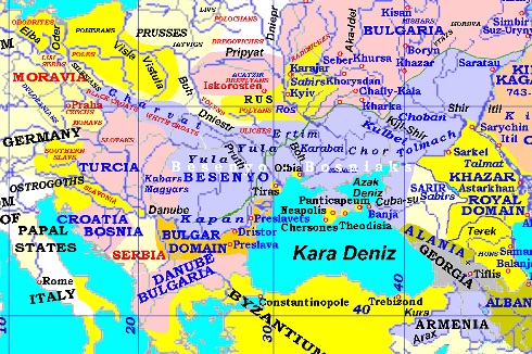
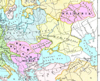
| Avaria and Kangar - Besenyo/Bosnyak state at 750-800 AD |
Krum Bulgaria at 805–898
(Balkans, Pannonia, and Atelcusu = Atelkuzu = Atelkiji |
 |
|
|
 Western Slavs
Slavic expansion to the north (Figs.
22 and 23), as in all other directions, would involve
overrunning and incorporating other fanning populations whose speech only gradually diverges from
core Slavic as the distance from there increases. The right flank of this northern move may well be
the old meeting boundary that dates from the time when the first incoming farmers were divided by
the eastern Carpathians. (If so, this line still exists after some 8000 years and today separates
the western from the eastern branch of modern Slavic.) The advance to the north would continue and
eventually overrun the southern part of what was by then differentiated as Baltic speech. The
remaining Baltics would adopt the heavy plow and thereby increase their own population density to
the point where the Slavic expansion loses its advantage and stops at 550 AD. The exact location of
this line of transfer cannot be predicted, but it could not be beyond the southern border of modern
Lithuania, which is the core area of Baltic speech today. The present border of Poland with the USSR is the most probable line.
These Baltics, in turn, would naturally continue this advance to the north and overrun some of their
Finnic neighbors in the same manner. Thus Latvia was added as a new area where Baltic speech was
overlain on a Finnic base — a linguistic description that is well known. The Baltic advance was
similarly stopped at the border of Estonia near 800 AD when these Finnic peoples adopted the plow.
They increased their population, took the new technology around through the Leningrad area and into
Finland, and eventually up to the northern limit of farming.
Just how much movement this caused among the Finnic-speaking populations is not clear. This two-time
transfer of the mold-board plow along the east coast of the Baltic Sea suggests that the area had been well populated before this event. At a lower initial density the natives might not
have been able to increase their numbers fast enough ever to be able to oppose the intruding plow
users.
141, 142, 143
More to the north-west (Figs.
22 and 24) the Slavic advance passed over the North European Plain,
unimpeded, to the shore of the Baltic Sea all the way west to the base of the Danish peninsula. They
stopped by 700 AD just short of cutting Denmark off from Germany. The eastern part of this new
Slavic territory was the old Celtic-related area, and the western part was Germanic.
North German tribes were in motion toward the west during, and no doubt because of, this advance of
the Slavic frontier. Saxon colonies that had been settled on poor lands in Britain in 450 AD (or
earlier) would have received many over-seas refugees from the east. This led to their rapid conquest
of much of Britain in just 50 years between about 550 and 600 AD.
Eventually these Germanics also brought in the heavy plow that was ideally suited to just those
areas in which they had been initially settled. Their inevitable local population increase, plus
continuing immigration, led to the final Anglo-Saxon takeover, and the ethnic assimilation of the
Britons, by 800 AD.
Not surprisingly this Germanic tide also stopped at Cornwall, Wales, and Scotland, just as the
Romans had before them. The mold-board plow was no better suited to effective use of these lands
than was the Roman villa system.
At about this same time, Germanic expansion on the continent engulfed western Netherlands, northern
Belgium, and a piece of northern France. Again, these were the low areas of heavy soil to which
their new plow was so well suited. Interestingly, this is the western half of the area already noted
for its non-Celtic and non-Germanic place names. Apparently neither the original farmers nor the
Celtic refugees from Germany were able to settle here very densely until this time. The rest of
France was too well populated and civilized to become Germanized, though most of it was overrun and
controlled by German-speaking minorities for
many years to come. The Franks are the best known of these invading tribes.
144
More directly to the west from the source point, Slavic penetration ran through the length of modern
Czechoslovakia, stopping finally at the western Carpathian mountain barrier (Fig. 22). Early along
this path the natives of the Slovak area were near-relatives of the Slavs. In Bohemia they
encountered the recently arrived Germans, whom they surely outnumbered. These early "Bohemians" who
evacuated their homeland are the obvious source of the German intrusion into Bavaria at about 500
AD. (Fig. 24). This was the old Rhaetic province of the upper Danube, whose native speech (whether Rhaetic or Latin) was replaced at this time. The Slavic advance expectably halted here from a
combination of the transfer of the heavy plow, denser populations resisting them, and a low mountain
barrier.
 Magyar Moves
The Magyar advance should have been affected by the fact that most of these people had only
recently become serious farmers. Previously their emphasis had been on cattle herding and horse
riding. Their later history suggests that they did not ever settle very densely outside of the
Hungarian Plain. What ultimately proved to be their firm boundary to the west was only 200 km
removed from their original homeland. They apparently did progress another 300 km to occupy the main
body of Austria, but gave it up readily to the German reflux a few centuries later (Fig. 23).
Given their equestrian skills and newly augmented population, Magyar armies periodically raised
havoc, especially to the west of their extended homeland. Atilla the "Hun" was merely their current
leader when the factors for expansion first developed.
145
The many supposed ethnic changes within Hungary during this and later times could have been no more
than changes in the political control of the nation. The historic waves of conquest out of Asia are
without any ecological foundation. A few tens of thousands (at most) of invaders will not change the
ethnic composition of half a million entrenched peasants without some mechanism that has yet to be specified.
|
The mechanism is widely known and used in social anthropology. Probably the best analogue is the
Spanish colonization of Latin America and British colonization of India, where the ratio of forces
in respect to the natives were hundreds/millions. The suggested here demographical estimate of “few
tens of thousands (at most)” is pure nonsense, just the field armies of the nomadic migrants
numbered (combined) hundreds of thousands, and the nomadic armed forces represented not more than
20% of the entire nomadic populace.
The time factor also plays a major role in the social
anthropology, the symbiosis of the nomadic Türkic masses and various local populations only in the
written records extends from the 7th c. BC (Cimmerians, Scythians) to the 18th c. AD. The symbiotic
interconnection between unequal partners is reflected in the mutual influences encountered in the
historical, social, technological, cultural, biological, and linguistic traces. No state of denial
may overturn the record of history. |
There is one case that can be made for a degree of ethnic change within Hungary. The original
development of the mold-board plow would have increased the population in the northeastern corner
by a factor of ten times or more, prior to its spread over the rest of the country. An explosion of
numbers, power, and prestige would engulf the rest of the country spreading from this spot.
Predictably, the dialect of this northeastern corner would have overrun all other dialects. The
significance of this is that the Vogul/Ostiak migration must have started out from this very same
corner more than 6000 years earlier. This then explains why modern Magyar resembles
(only vocally) Vogul/Ostiak
more than either of them resembles the other two branches of Uralic. If a different dialect within
Hungary had prevailed over the others, then the relation between Hungarian speech and the three
outliers would have been different.
This reconstruction presupposes that the differences between the Uralic dialects of 6000 BC were
in some ways greater than the amount of contrast that has accumulated since then between Vogul/Ostiak
and Magyar. This suggests a slow rate of change in recent millennia, and a two or three times longer
period of differentiation among the original dialects in Mesolithic Hungary. These contentions are
presently neither supported nor disproven by other data that might pertain to these languages.
146
 Southern Slavs
To the south, Slavic fanners spread over nearly the entire Balkan Peninsula (Fig. 22) . A western
branch of them overran the southern part of the Hungarian Plain, and advanced to the Adriatic coast
and into the Eastern Alps. In this direction the only human population that was numerous enough to
resist this tide was just within Italy itself.
Subdivisions of Slavic in this area probably relate to underlying language differences in the
previous population. Slovene in the far northwest, as well as the adjacent Friulian language in
Italy, may owe their distinctions from their respective neighbors in both directions to the previous
Venetic language. Friulian has also been associated with the old Rhaetic of Bavaria and Austria,
which may have been Latinized during Roman times. If Venetic was also Latinized, then it was just a
distinct dialect that underlay the area of both Friulian and Slovene. (See Fig. 24.)
Croatian on the inland side of Yugoslavia, as well as Dalmatian on the Adriatic coast, are
differentiated from their neighbors by their presumed incorporation of preceding Latin speech.
Bosnian Slavic exists on what should still have been Illyrian territory at that time.
|
The problem of historical reconstruction for Croatia, Bosnia, and Herzegovina lays in numerous
layers of Türkic admixtures that tended to blur the traces of the original vernaculars, the
supra-ethnic nature of the Ottoman state, and the rise of the nation-state concept in the 18th c.,
which led to inter-ethnic conflicts, sporadic genocide campaigns, and biased scholarly neglect of
the unsuitable portions of the history. The linguistic apotheosis of the perverted history was the
state-sponsored purge of the dictionaries from the native lexicon, and substitution by politically
correct alien lexicon. However, in Bosnia, and Herzegovina the traditions of symbiosis and
co-existence were so ingrained that it took a full force of the post-WWII Yugoslavian dictatorship
to temporarily impact millennia-old traditions of symbiosis, mutual understanding, and mutual
respect. |
A central branch of southern Slavs overran most of the Illyrians, leaving only remnants in the
mountains of Albania (Fig. 23) . They also pressed on into Greece and overwhelmed most of that
country except for some coastal areas and cities (Fig. 24). Limited Slavic penetration of Anatolia is also reported. Displaced (or expanding) Albanians
participated in the invasion of Greece (Fig. 23). Both Greeks and Albanians also moved in large
numbers by sea to settle in small patches of Sicily and southern Italy, adding to earlier Greek
inhabitants, where they remain today. This whole southern flood had reached high tide by the year
800 AD, and then the Hellenizing reflux began immediately to work its way back up the peninsula.
An eastern branch of the southern Slavs swept down the Danube basin to the Black Sea, occupying
modern Bulgaria in the process (Fig. 22). This move almost coincided with the Turkic
move that is proposed here, also based on the plow, out of steppeland extension along the lower
Danube (Fig. 23). These were the Bulgars of history who were the dominant ethnic group there, given
their equestrian military force. They would necessarily be numerically inferior to the Slavs who
eventually prevailed. The Turkic Bulgars were no doubt in the area first, and they are the ones who
introduced the mold-board plow into Anatolia. One need look no further than northern Bulgaria to
find the Bulgar homeland that is usually placed far to the north-east in the Pontic Steppes. Their
detailed history is discussed shortly.
Slavs were brought to Bulgaria by Asparukh at the end of 600s, see
Runciman S. FirstBulgarian Empire. These were the same Slavs that Avars and Bulgars
resettled along the Avar-Bulgar border at the end of 500s to serve as border guards, and elsewhere
around Kyiv (Bashtu and Shambat at that time) for other utilitarian purposes. These were also the
same Slavs that Shambat (Samo of western chroniclers) brought over from Czechia and Slovakia when he
retreated back to Kyiv. Asparukh inherited all subjects, including Slavs, that belonged to the
Western Wing of the Kurbat's Great Bulgaria.
Independently, and before the Asparukh's social
engineering, Avars and Kangars (Kangar tribes Charvat, Yula, and Ertim) brought their Slavs from the
Northern Pannonia to the Balkans, replacing the previous Greek and Roman settlers who evacuated from
the Balkans in the preceding tumultuous period of unending wars and devastations. In both cases, the
migrants probably carried along their household implements. The Danube Bulgaria that Asparukh
inherited likely had already contained Slavic farmers relocated during previous centuries. All these
migrants, syncretized with their Türkic masters, formed the distinct division of the Southern Slavs. |
147
This eastern branch of the southern Slavs also constituted the right wing of the two-pronged Slavic
sweep around the old Roman province of Dacia. They absorbed the remaining Bulgars and moved slightly
north along the Black Sea coast.
 Romania
Most of Dacia, now Romania, was probably in the process of being Latinized for the same reasons
as in western Europe.
The major part, in the west, was overrun by Slavs by 400 AD.
The barrier ring of the eastern Carpathian Mountains would have retarded this advance long enough
for the Romans and Turkics on the other side to adopt the heavy plow and begin their own expansions.
The Roman colonies in the foothills extended their arc of occupation from south through east, and
naturally overran most of the Turkic people who had bordered them here in the grasslands (Fig. 24).
Two small remnant groups of this Turkic population still remain in the area (Fig. 23). The Slavic
tide then automatically spread to these Roman colonists from around both sides of the mountains,
blocking any further Latin expansion, and absorbing most of the remaining Turkics (Fig. 22). The
Slavs had
begun their expansion long before; by comparison, these Latins had built up only a small population
impetus for their own move. The Latins occupied the mouth of the Danube, but the Slavs closed in
from both directions along the Black Sea and almost cut them off from it.
148
After the Slavic advance ended, the Latins soon re-asserted their ethnic dominance over the original
province of Dacia, much like the Greeks did in their own area. A large Slavic component was merged
into this new linguistic entity. The only item that remains unexplained here is the Magyar
population in Transylvania, near the center of Romania, and some more small colonies between there
and Hungary itself.
 Turks
Turks
After the mold-board plow was adopted by the Latins of Transcarpathia they would, in turn, pass
it on to their immediate neighbors along the Black Sea coast and lower Danube valley. The breadth of
Latin occupation was so little that they could not have augmented their level of population enough
to immediately overrun all of these neighbors. These were the Turkic inhabitants of the steppe
region of grass and deep soils that extends to here from the Ukraine. This is the westernmost end of
the Eurasian grasslands that must have been inhabited by Altaic herdsmen since the earliest
Neolithic. Just like the Magyars, these horse-using pastoralists were in close contact with
agriculturalists, and had immediate access to their technology and experienced personnel.
As with the Magyars, we would expect them also to adopt the heavy plow and increase their
population, but not at first with the same intensity as the more agriculturally oriented Slavs.
|
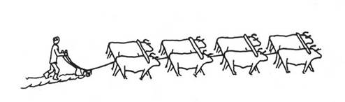
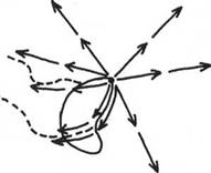
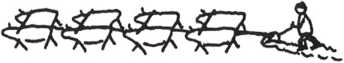
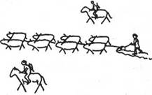
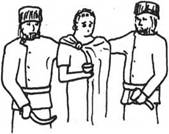
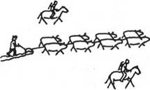
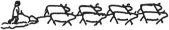
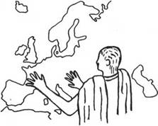
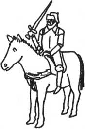
Looking into binoculars from a wrong end surely misrepresents the picture in front of you. The
picture at the right better reflects the reality than the presuppositions piled up for a theoretical
foundation. The Türkic nomads were diligent in tending to their property, be it the movable property
of human and animal chattel, their mobile homes, or their gardens. In the course of tending, they
had to make sure their humans and animals have access to good supplies of food and water, and are
securely protected. When they had to move, they did not leave their property behind, if they could
help it. The preamble picture depicts a land tiller working under protection of the armed nomads, a
true representation of the situation. The Türkic nomads had as much interest in tilling the turf
as planters have interest in picking cotton themselves. In their own way, they had the same conception of the
class difference as the Roman and Persian slaveholders, or feudal class. Tilling the dirt was
beneath the station that took pride in being warriors and free proprietors. The idea that advanced Latins
could pass their dirt-tilling implements as a blessing to freedom-loving armed nomadic masses is a
no starter. Only utter desperados beyond poverty level could descend to a shameful occupation that
is firmly associated with a status of bondage and subjection. Likely, the former
hunters-turned-nomads Magyars acquired not only the technology of horse pastoralism, but also the
nomadic mentality of freedom that made them live of their weaponry and not of their plows.
Where the scholarly binoculars showed that sedentary farmers had better access to technology and
experienced personnel, the reality was that in the pre-modern world, the mobile steppe nomads not
only had access to the numerous peoples across Eurasia totally inaccessible to enclaustred farmers, but had a capacity to spread that learning
from one Eurasian corner to the opposite side. That is how the bronze casting reached China, and
socket axes went from Mesopotamia to Altai and on to China.
The Wallakhs, and the Dacians, who in
the middle of the 19th c. turned into Rumanians, came from two different phyla. Wallakhs retained
their pastoral lifestyle well into the 20th c, their main fare was sheep husbandry, they were good
with gardening and viticulture, and not much into the grains. The Dacians, former Gets, former
Goths, also were more on the nomadic side, although they did have farming traditions, and some of
the stipulations applied to the spread of farming may be applicable to them. The post-WWII switch to
Soviet-style re-orientation on industrial bread-growing wrecked havoc on the Rumanian peoples,
severely impoverishing them. Their traditions are reflected in the genetic composition of the
Rumanians. The Romanians' Y-DNA shows Hg I 37.4%, R1b 14.6%, R1a 10.6%, J
9.3%; or 40% local Paleolithic (Hg I), 10% Middle Eastern farmers (Hg J), 15% Celtic
and/or Türkic Kurgans (Hg R1b), and 10% Paleolithic pre-Kurgans turned to farming (Hg R1a).
The Moldavians' (aka Wallachs) Y-DNA shows Hg I 30.1%, R1a 27.6%, R1b 16.7%,
E1b1b 12.8%; or 30% local Paleolithic (Hg I), 27.6% Paleolithic pre-Kurgans turned to
farming (Hg R1a), 15% Celtic and/or Türkic Kurgans (Hg R1b), and 10% local
Mediterranean Paleolithic (Hg E1b1b).One way or another, the Moldovans relate to their
Brahman kins in India marked by the R1a Hg, they also have notable linguistic commonalities
with Indo-Iranian migrants who reached South-Center Asia in 1500 BC. Before migrating to Moldova,
Wallakhs were close to Illyrian mountains, living in the similar foothills as they found in Moldova.
Thus, the Latinization of Wallakhs likely took place in the vicinity of Dalmatia, and is unrelated
to the Pruth valley and spread of farming shown on the Fig. 24., |
149
This strip of grassland runs for about 500 km along the Black Sea coast, extending inland about 150
km in most places. On the lower Danube it runs over 400 km inland, but this projection is less than 100 km wide. In
terms of subsequent events this Balkan grassland strip can be subdivided into three major parts — the
northern part bordering on the Ukraine, a middle section surrounding the Danube delta, and the
southern projection running up the lower Danube.
In the northern part, Latins would expand into the deep soils and make the plow available to the
local Turkic natives. Most likely the Turkics failed to adopt it here in northeastern Romania. These
people were in only partial contact with farmers, and were contiguous with a large area and
population of other pastoralists in the Ukraine. If they ever did begin any deep plowing they were
probably soon overrun by the Slavic farmers from the north. The Turkics of this area were absorbed
by Latins and Slavs.
|
The claim about Latins (i.e. Wallakhs) and Slavs is quite dubious, giving credit to where it does
not belong. Thrace and Dobruja at the turn of the eras are known to be Scythian territories, with
the rise of the Huns the Scythians fell under their suzerainty, and remained there as tribes of the
Right Wing (Western Wing), called Köturgur > Kutrigur ~ Cutriguri in Greek rendition, after the fall
of the Huns and the rise of Bulgars. After the rise of Avars, the wings were reformulated, and
probably the Hunnic Right Wing became the Avar's Left Wing. In the Hungarian time, the same area was
populated by local Seklers with ethnonym consisting of Sek + pl. suffix ler, where
Sek is the same as in Scyth, Saka, Iskit, etc. Seklers survived unmolested till 1920,
when Transylvania was transferred to Rumania, and Seklers were deported to Hungary. Besides Seklers,
Rumanian territory retained other Türkic tribes, as evidenced by 15% admixture of Hg R1b. |
From the middle section there was no available space into which Turkic horsemen-turned-plowmen could
expand. While they would take up farming, they were trapped against the Black Sea by expanding
Latins who had most of the advantages. The present Gagauz enclave in eastern Romania is best
explained as remnant of this Turkic population.
Along the southern strip these Turkics would naturally adopt the plow from the oncoming Latins. (See
Fig. 23 to follow this whole Turkic move.) In this case there was open territory to the south into
which they could expand over the local Thracian farmers who did not yet have the heavy plow. These
Turkic peoples would have the same combination of horse-based mobility and a new-found farming
technique that characterized the Magyars to the north-west. Their rapid, but still relatively
sparse, expansion over all of modern Bulgaria and beyond would be the automatic result.
Very shortly behind this Bulgar expansion a dense population of Slavic farmers would naturally
spread over the same area, entering from the north-west. They would have the same plow and with
more experience in its use, but would be without the use of horses. Given the greater mobility of
the Turkics, and the greater numbers of the Slavs, they would more easily mingle than form a
boundary between each other. The more horse-oriented group would be militarily, and hence
politically, dominant over the other. This, then, is the quite natural origin of the Bulgarian
state.
150
Greek coastal strips and cities (including Constantinople) mostly held their ground against the wave
of Albanian, Slavic, and Turkic intruders. As far as the Balkans are concerned, this was about the
limit of these movements. But across the straits in Anatolia there occurred an important extension
of this historical process.
Turkic horsemen/plowmen would have had first access to cross into Anatolia, and to expand there with
the new agricultural techniques. Their major crossing can be put at the Dardanelles, rather than at
the Bosporus where Constantinople is located. By this time the Turks (as they may now be correctly
called) had advanced 400 km with the use of the mold-board plow, taking maybe 200 years to
accomplish this move. With even half this much experience, it might be expected that their
agricultural abilities should have improved considerably. If their density of settlement had
increased enough they would be able to form an ethnic frontier that could resist further
infiltration and incorporation by the advancing Slavs. A stable Turkish frontier ought to form in
the southeastern corner of the Balkans. The present Turkish ethnic border is at this appropriate
location. This frontier does not pass across southern Bulgaria at a constant 200 km from the Turkic
starting line, but includes only the eastern end of that potential zone. This may result from the
fact that the Turkic source area on the eastern end was much larger than its projecting western tip.
If their migration was primarily southward (as would be natural), the eastern end would have
included the greatest numbers of them.
Within Anatolia these Turkish farmers would spread automatically over the entire central area,
engulfing the mostly sparse local inhabitants. They would leave only the coastal strips and cities
in the hands of the Greeks and other Indo-European nationalities. Except for the strong hold of Greek on the western fringes against the
Aegean, these non-Turkish enclaves were eventually absorbed by the new dominant ethnic group.
151
Farther to the east in Anatolia the major part of the Turkish-speaking frontier today ends along an
arc that centers on the Dardanelles, and that would mark their advance line at 1170 AD by the
schedule used for this movement. On the south, Turkish stops short of this arc, roughly on the old
Semitic frontier at the Syrian border. On the north it extends another 350 km for no obvious reason
into what should have been Caucasian territory.
The intrusion of the Seljuk Turks from the east in the 11th Century brought Islam and a higher
degree of political organization. This would have been a significant factor in later absorbing the
coastal enclaves, but it could hardly account for the major spread of Turkish in the main part of
Anatolia. I suspect that extant records of the Seljuks might indicate whether they found linguistic
relatives already occupying the area.
The total Turkish advance indicated here is 1300 km from their source area, and it should have taken
them almost 700 years to accomplish. Eventually the heavy-plow technology would have passed on to
other peoples in eastern Anatolia — Kurds, Armenians, and Caucasians. As long as the plow continued to
be useful these people would have made their own geographical adjustments. Such further movements go
too far afield to be dealt with here.
A major significance of this Turkish expansion, other than explaining it for its own sake, is that
it marks the first physical separation of the Indo-European languages into European and Asian
geographical divisions. The dialect mesh had been broken much earlier, allowing the two halves to
drift freely from one another. By 500 BC Greek probably had spread far enough to effect a language
break between the Balkan and Anatolian dialect. It is even possible that the Hittite Empire or
other events had created such a break even earlier. But until this Turkish intrusion, the
Indo-European family of languages had
occupied a contiguous territory.
152
 Eastern Slavs
The eastern Slavs constitute what ultimately became the largest division of this language group.
Their expansion was generally to the north-east, and it nowhere encountered any major groups of
densely settled or highly civilized peoples who could seriously impede their progress. (See Figs.
22
and
25.) Their farming was effectively blocked by the 120-day growing season on the north and by the
semidesert region on the south. This long eastern advance, overrunning previously farming peoples,
appears to have progressed at a regular rate of 200 km per century all the way
to its natural limits.
'The dividing line between eastern and western Slavs (now Russia vs Poland) lies approximately at
the meeting of the original farmers who had first passed around the two sides of the eastern
Carpathians. To the east of this line the Slavs overran remnants of the original Indo-European
dialect mesh. These were first the Slavic-related people who lived south of the Pripet Marshes, and
who extended considerably to the east. Their area of incorporation is within the modern Ukraine, as
is their subsequent area of further extension into the steppes. The basic language for the source of
the eastern Slavic expansion is thus identified as proto-Ukranian.
North of these marshes the native people who were being incorporated by the Slavic expansion were
the interior Baltics.
By 650 AD their original area would have been overrun, and they do not exist today. Its boundaries
coincide so nearly with Belorussia that the source of the distinction of this modern language seems
to be clearly identified.
153
The remainder of the eastern Slavic advance was over the
Uralic tribes that are here divided into Samoyed (i.e.
Nenetses) and Vogul/Ostiak sections. Some Finnics soon got
into this area as well. Those Slavs who overran a base of Uralic peoples are known today as Great
Russians.
During the first half of its advance to the north-east, the Slavic left flank continued to parallel
the Baltic coast at about 200-250 km inland. This flank ran along the ancient dividing line between
the paths of the original Finnic and Samoyed (i.e.
Nenetses) pastoralists (Uralic groups II and III) . The coastal
zone received its heavy plow from the western Slavs and was probably well populated even before
this. The inland area was more thinly populated, and the native Uralics here evidently were not able
to adopt the plow readily enough to hold their ground at any point.
After the eastern Slavic advance passed the original Indo- European occupation area, a new
geographic situation arose that caused two major advancing fronts to intermingle. When the eastern
Slavs pass the Gulf of Riga, their left flank turns from north-east to due north as it continues to
parallel the coast.
In other words, the Great Russian advance fans out somewhat to their own left. This then comes into
conflict with the advance along the Finnic path near the coast. (See
Fig. 25 for this and further Finnic moves in Russia.)
|
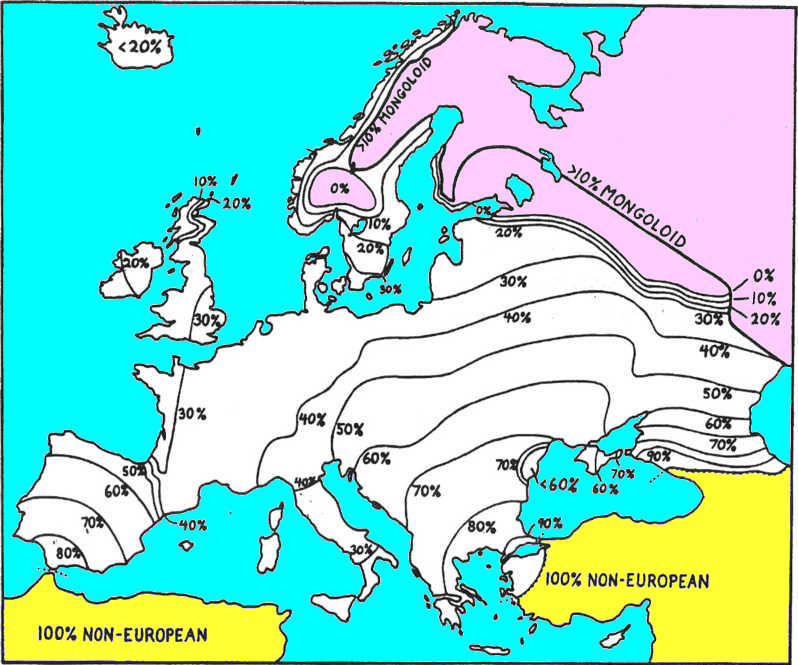
Fig. 25. Finnic expansion. Changes are shown for Finnics,
Caucasians, and Slavics far from the origin of the heavy plow. Finnics lose Latvia and part of
western Russia. They moved east ahead of the advancing Slavics, lost much of this new land, but held
some enclaves and a large area in the east. They also joined in the plow-based penetration of the
Steppes. Caucasians
lost ground in the south and advanced a bit northward. Eastern Slavics are shown in heavy outline as
of 1600 AD. They are the major source of immigrants into the Pontic Steppes, with dates indicated.
In the north a dashed line marks the 120-day growing season; dashes in the center-east show the
deep-soil margin; and dashes farther to the south-east mark the desert edge. |
 |
As heavy-plow agriculturalists advance into deep-soil locations, some of the local farmers can be
expected to retreat in order to avoid being surrounded and incorporated. This kind of retreat is
possible only into lands that are not already densely settled. Interior Baltics probaly did just
this and moved their frontier 60 km beyond the Dvina River before they were finally overwhelmed. The
denser population of Finnic farmers in modern Latvia faced a different situation and had the numbers
to do something about it. The western half of this country (Courland) was a cul-de-sac in the north,
and its people were probably well aware of this. Accordingly, large numbers of farmers, especially
from western Latvia, would be expected to gather all their belongings and shift to the east to avoid
being engulfed by Lithuanian plow farmers. This move puts these Finnic
farmers directly into the path of advance of the eastern Slavic plow farmers instead.
154
In the region immediately to the east of Latvia, Slavic farmers were fanning out to their left (due
north), and Finnics were spreading directly into them with their own turn to the right (due east).
The original natives here were so sparse that the intruding Finnics would be second only to the
Slavs in numbers. This is just the condition that is known to have occurred in the Novgorod area in
850 AD at the founding of the first Russian state. The Slavs had the better equipment and would
soon have the numbers to dominate the society. The original Finnic farmers who remained would occupy
islands of lighter soils, or they would adopt the heavy plow. Many such enclaves exist in this area
today. Other Finnic farmers would have moved on to the east, eventually to become the Mordovinians.
More on them later.
A similar shift to the east by Finnic farmers would again occur at the Gulf of Finland. This time
the refugees pressed into a narrow corridor through the Leningrad area, while some continued to the
east to become the Komi. The adoption of the heavy plow by Finnics at the Estonian border would
relieve at least the ethnic basis for further pressure, and the spread of the plow would assure
Finnic identity in this corridor up to modern times. (The later Russification of Leningrad itself
follows automatically from geographical considerations of modern state policy.)
Finns and Slavs would have passed around their respective sides of Lake Ladoga and met again on its
northern side. The advance of both groups was halted here by 1100 AD along the 120-day growing
season line until more recent times.
The Finnic farmers out of Latvia and Estonia evidently had a continuing history of some interest.
Large numbers of them could have avoided being engulfed by the Slavs simply by continuing their move
to the east. Even without the heavy plow, their farming skills plus their numbers should have been
sufficient for them to pass through the sparsely settled interior of Russia — given sufficient
motivation. By moving just 1.6 times as fast as the Slavic frontier, these Finnics could slip to the
east and avoid encirclement. This means taking a crop or two, then moving, and repeating this many
times without leaving significant numbers behind. This was an actual migration, not a frontier
extension which is unable to advance at that speed anyway.
155
There are still many Finnic enclaves just to the east of Latvia where the first intermingling with
Slavs occurred. Beyond this there ia a long gap with none of them for the next 500 km across central
Russia. Then Mordovinians are encountered in great numbers. Evidently these Finnic farmers out of
Latvia reached and filled-in the last corner of arable land in the east, where it tapered down and
pinched out between the growing season to the north and the deep soil to the south. The oncoming
Russian advance would have reached them at 950 AD, to judge from the location of the westernmost
surviving examples.
The Mordovinians (and related peoples) now occupy only about one-tenth of their "natural" area in
this corner. Displacement by Russians would have been abrupt in this first contact with people using
the heavy plow, but Finnic speakers have lost ground in recent times as well. It can be seen that
the Mordovinians also managed to adopt the mold-board plow, because their area extends about 300 km
into the deep-soil region at their eastern extreme. Here they are again dissected by Russian speech,
which demonstrates recent absorptions.
|
Endonym Mordva was used by Jordanes (6th. c.) in the form Mordens, subjects of Gothic king Ermanaric
in Getica. The Gorodets culture in the Itil area, dated to around 500 BC, is attributed to
Mordvins.
The Mordvins also first show up in the annalistic and geographical descriptions under a Türkic
exonym Burtas (~ Murtas/Burdas under b/m alteration) meaning Honey Tribe, with burt =
apiarian + as = tribe. At the time, honey was the only sweetener used and it also was used as a
preservative; the demand was unlimited, and its transportability was limitless. The appellation
based on trade was a common form of exonym, it pointed that Mordvins of the 6th-12th cc. AD were
predominantly hunter-gatherers farming hollow-tree beehives that requires large territories and low
population density. Mordvins were never known for their military significance, their defense was to
melt away into forests. The scenario that Mordvins came to the Middle Itil area in the 900s as either ard or
heavy plow farmers, and then reverted to hunter-gathering conflicts with the historical records. |
Mordovinian distribution shows yet another peculiarity at its extreme eastern end. They do not
occupy the very last piece of the cul-de-sac between short seasons and desert; this spot is held by
Turkic pastoralists with ethnic connections still farther to the east. Mordovinian occupation ends
some 250 km south of the present 120-day growing-season line, while cattlemen occupy much of the
potential farmland north of the Mordovinians and up to the crop-growing line. This seeming malpositioning of the two is almost the reverse of what might be expected at first glance. (See
Figs.
1 and
25.)
156
Actually, if one assumes the growing-season line was shifted
250 km to the south after the year 1050 AD, then the Mordovinians would have exactly filled the
last existing farming space at the eastern tip. (This suggested lowering of the farming limit may
correspond to the deteriorating climate in the North Atlantic at a slightly later date, which
terminated the Norse colonies in Greenland.) If the original use of cattle spread across the steppes
slightly faster than it did in the forests, then a considerable area of tillable eastern forests
could have been held by Altaic cattlemen. This area would later be lost to the Finnic, and then to
the Slavic farmers, but only up to the limit of the growing season that was displaced southward at
that time.
|
The idea that horse husbandry “Altaic cattlemen” could lose anything to farming communities is
preposterous; for 6 millennia the “Altaic cattlemen” did not have any military competition, from the
time of invention of the horse husbandry technology to the invention of the cannon guns. They are
known to have created a series of largest states in the world history, ruled innumerable hunting and
farming people, and had very few military setbacks in the course of their history. During the period
of their dominance, their setbacks could only be brought up by acquiring and using their own
superiority against themselves. |
Another part of the Finnic retreat was out of Estonia and across Russia to the Komi area. This is
mostly to the north of the normal limit of farming, but where oats, barley, and rye are grown
today. Here they are pressed up against and between the Samoyeds (i.e.
Nenetses) and Vogul/Ostiaks, where they
overran some of these peoples and even spilled over the Ural Mountains. They had to abandon much of
their usual farming and crops to inhabit this area. The area of occupation follows no obvious
pattern except as another effort to avoid Slavic encroachment. Since many Russians have made similar
moves into the north, it is best left unexplained except to say that it is a recent, civilized
phenomena. (See the north-east corner of Figs. 26, 28, and
25, in that order.)
While the eastern Slavs advanced rapidly across Russia, they also moved into the deep soils of the
southern steppe region with the essential aid of the mold-board plow. These Pontic Steppes were then
occupied by Turkic pastoralists, with little or no agriculture, who would have harassed the
intruding farmers. On the other hand, improved communication and transportation of the time would
have meant a much deeper frontier-feeding zone that could provide large numbers of pioneers. To the
local ruling nomads, whether Sarmatians, Mongols, or Turks at various times, the ethnic identity of
these farmers would make little difference so long as they could tax the wealth that was being
created.
|
The points on irrelevance of the ethnic identity and fiscal nature of the nomadic-farming relations
(or any other trade, like mining, beehiving, charcoal production, etc.) are most fundamental. It is
a patronage system that spilled into Western Europe in a form of of the Middle Age feudalism. The
corollary of the patronage system is symbiosis, interspersion, and biological amalgamation of the
Türkic peoples with their host subjects. Understanding of the patronage system largely precludes the
aggressive farming expansion promulgated in this work. |
157, 158
I have found that political maps of southern Russia do not reflect linguistic groupings of the real
people any more than similar maps do in the rest of Europe at that time.
The advance of eastern Slavs into the steppes was certainly faster than the rates used for the first
Neolithic farmers in other areas. After mapping the area with several different rates, I found that
a base rate of 120 years (four generations instead of five) per 200 km, plus the usual penalties,
seemed to fit best with both logical expectations and historical data.
The early advance of the heavy plow out of its source area was at least retarded, and probably
stopped, by the barrier of the eastern Carpathians. It had reached the Latins of Dacia on the far
side of these mountains by passing around both ends at nearly the same time. From these two ends,
the use of the plow would move through Latin territory toward the mouth of the Danube. As already
noted, the Latins then spread out into the grasslands where the Turkics were also picking up this
new agricultural technology. At the same time Slavic farmers were making parallel sweeps around
these mountains, but farther out to each side, well to the south and to the north-east of the Latin
speakers.
The Slavs had both temporal priority over, and a deeper frontier-feeding zone than the Latins. At
about 500 AD both Latins and Slavs entered the steppes to the south and the northeast of Romania,
but the Slavs expectably blocked the slower Latin advance. Both arms of the Slavic advance curved
around the Romanian effort, reached the coast of the Black Sea, and came just short of cutting them
off at the mouth of the Danube.
The left arm of this sweep, the one to the north-east of Romania, represents the first entry of the
Slavs into the great Eurasian grasslands. At their presumed rate of advance, these farmers reached
the Black Sea at 700 AD, and Rostov-on-the-Don at 1400 (Fig. 25). Continuing this schedule to the year 1900 would have them only partway into the Kuban and first contacting the Caucasians, and not
yet on the far side of the Urals. Since these last events are in fact badly misdated, it is clear
that
recent centuries have seen a great increase in their rate of advance. Political unification and
railroads have made the entire country a feeding zone for the frontier.
159
Within the steppes a contrast between Ukrainian and Great
Russian speech persists. Ukrainian coincides with those pioneers
whose last forest contacts were with Slavic-related Indo-Europeans. Russian coincides with those pioneers whose last
forest contacts were with Uralics. Until the year 650 AD the
only Slavs in the steppes were of the Ukrainian type. After that
time all new immigrants, passing from forest to steppe, were
Russian. By extending from this division at their point of
entry, a line is generated that runs close to the present
language frontier. If the Ukrainians are granted a slightly
deeper frontier-feeding zone this would serve to spread their
advance 15° to their left at the expense of the Russians; then the dividing line is on the actual
frontier. Sometime after 1500 AD the political control by Russians mostly blocked the Ukrainian
advance at their current line.
 Language Map
The year 1100 AD is chosen from a range of possible dates to represent the stable condition as far
as most of Europe is concerned (Fig. 26). It is selected mainly because it immediately precedes the
German reflux to the east, which is the major item in the next event. It also catches the Slavic
move to the east well short of its maximum extent, but that cannot be helped — this move was not
completed until even well after the following German action had run its course. In fact, it is
continuing even today.
Distributions in southeastern Europe at 1100 AD reflect a rolling back of the Slavic frontier from
its maximum extent of about 800 AD. (Compare Figs.
22 and 26.) Exactly where some of
these frontiers had moved by this time had to be estimated.
|
Fig. 26. Language map in 1100 AD. The Slavic explosion to the west, south, and east is the major
feature. Other languages had considerable areas lost and gained from the use of the heavy
plow. Pictish is lost (according to historical sources), and Afro-Asian has reinvaded Iberia. Some
'•civilized" refluxes occur in Greece, Romania, and the German occupation of Austria. Uralic is the
biggest loser of ground. The Caucasian shift is not shown because it happened after 1100 AD. The
Anatolian-Semitic boundary is now arbitrarily adjusted to its modern position. |
 |
The Magyars of Transylvania (i.e. Seklers, one of the strongest tribes
of Eastern Huns), in the middle of Romania, are not indicated because I don’t know how or
when that move occurred. Turkish is stopped on its presumed line of 1170 AD without showing its
penetration of Caucasian territory that should have occurred later.
|
The arrival of the Türkic As tribes from the Balkh valley named Balkh-gur (Bulgar) in the Caucasus
was recorded in 45 AD. The Türkic tribes of Kayi, Huns, and Masguts/Massagets occupied the western
Caspian seaboard from 150 AD. Armenian Bishop Kardost in 520 “produced there a Scripture in the
Hunnic language” for the Caucasian Huns. Scythians had a state called Sakasena in the Azerbaijan in
the S. Caucasus; before 20 AD, Strabo located Σακασηνη Sakasena between Kura and lake Sevan; horse
nomadic tribes bearing Türkic names Guties, Kumans, Suvars are known in Mesopotamia since 23rd c.
BC. The Koban culture in the Caucasus was a symbiotic Scythian culture. What 1170 AD has to do with
that? |
It was the Uralic family that had lost the most ground to the Slavic explosion as of this date, and
these losses would continue over the next few centuries. The eastward shift of much of its Finnic
part somewhat moderated this loss to the family as a whole. The Altaic family similarly lost much
ground to the eastern Slavs, and has continued to do so until modern times. Again, one of its
subdivisions made progress elsewhere — here in the form of the Turkish spread over Anatolia.
|
In real history, Türkic people did not lose their Eastern European territories until starting about
1550, under a military pressure from the incipient Russian state. The Russian military conquests did
change the ethnolinguistic situation in the Eastern Europe, especially after 1700s, but that has
nothing to do with the expansion of farming. |
Many language groups went through a two-step process of losing ground to the Slavs on one side, then
after acquiring the mold-board plow, gaining new territory in the other direction. (These are shown
in the before and after maps of Figs. 23 and 24.) Clear examples of this process are seen in
Germanic,
Baltic, Romanian, and Albanian. If one ignores the fact that Magyars participated in the origin of
this move, they can also can be seen in terms of lost, held, and gained territory. Some groups lost
ground to the Slavs and gained nothing, like Samoyed (i.e.
Nenetses), Vogul/Ostiak, Greek, and Latin in the west. In
other cases ground was lost to non-Slavics who had acquired the heavy plow.
Two special cases of plow-induced shifts show losses and gains, but without a full middle ground
that was held throughout the process. A large gap exists in the Turkic distribution where they had
gained new territory with the plow to the south of their homeland, then later lost some of this
(Bulgaria) to expansions by denser Slavic populations. The Finnic distributions show an even larger
gap between their homeland in the Baltic area and their penetration of the steppes in eastern
Russia. Again, it was Slavic farmers who were able to overrun the territory that was occupied only
temporarily by the eastern Finnics.
|
Again, Türkic gains and losses of the territory have nothing to do with plow. The Anatolian Turks
started grain agriculture in the Ottoman times, employing supra-ethnic labor from the Balkans and
local farming laborers like Greeks. Grain production took off in Turkey only at around 1900s. |
162
Perhaps the most significant aspect of this whole episode was the loss of the last remnant of the
(erroneously presumed) original Indo-European dialect mesh that had persisted in eastern Europe. At this point all of it is
subdivided into new dialect meshes, within recently formed boundaries, that are evolving
independently of each other. The (erroneously presumed) previous contact between the European and Asian halves of this
family are also now irrevocably separated by the deep interjection of the Turks.
Latin-derived speech remains dominant in the west, though they now should more properly be referred
to as Italic (or Romance) because of the many subdivisions that have become separate languages.
Italic lost ground directly to Slavic in the western Balkans, and indirectly in northernmost Gaul
where Germanics overran that area with the aid of the Slavic plow. The Rhaetic area of Bavaria and
Austria, as well as all of England, were Germanized by this time. But it is not clear whether either
area should have been classed as truly Latinized before this. I labeled Rhaetic as original and England as Latin in an earlier map (Fig. 21), but this was
arbitrary and might even have been correct the other way around.
Latin also lost whatever it may have held in North Africa to the Semites after 675 AD, in an
action totally unrelated to the mold-board plow phenomenon. This returned the area to the Afro-Asian language family that had evidently occupied it in the initial Neolithic spread. Semitic Arabs
also gained control of most of Iberia and were in the process of Arabicizing the population. Their
limit is drawn rather arbitrarily near the middle to include the area that was under their
domination for the longest time. They do not appear to have made significant or long-lasting contact
with the Basque hold-over from the earlier Afro-Asian incursion.
|
According to the dated genetic phylogeny, “the Basque hold-over from the earlier Afro-Asian
incursion” is in fact the R1b circum-Mediterranean route of Kurgan people from the N.Pontic,
a part of the Celtic arrival in Iberia at 2800 BC. |
Western Celtic continued in Brittany, Ireland, Cornwall, Wales, and Scotland. The last three of
these are at this time separated from each other by the Anglo-Saxon intrusion, but they had already
been separated by the Roman occupation of just the same area.
Pictish has disappeared from Scotland by this time, having
been replaced by the Celtic speech of Ireland (The agglutinative Bask
language leads to a conclusion that original Celtic and
Pictish were also agglutinative languages of the same origin). One can visualize the Picts as a small ethnic group,
under pressure from the Anglo-Saxons and Vikings, voluntarily merging their cultural identity with
the only significant rivals to these Germanic threats.
The Lapps would have lost significant ground to northward-expanding Scandinavians, but the line
drawn here is no more than an educated guess.

 The Empire
(area 3rd c. BC - 4th c. AD)
The Empire
(area 3rd c. BC - 4th c. AD)
 Language Effects
 Language. Map
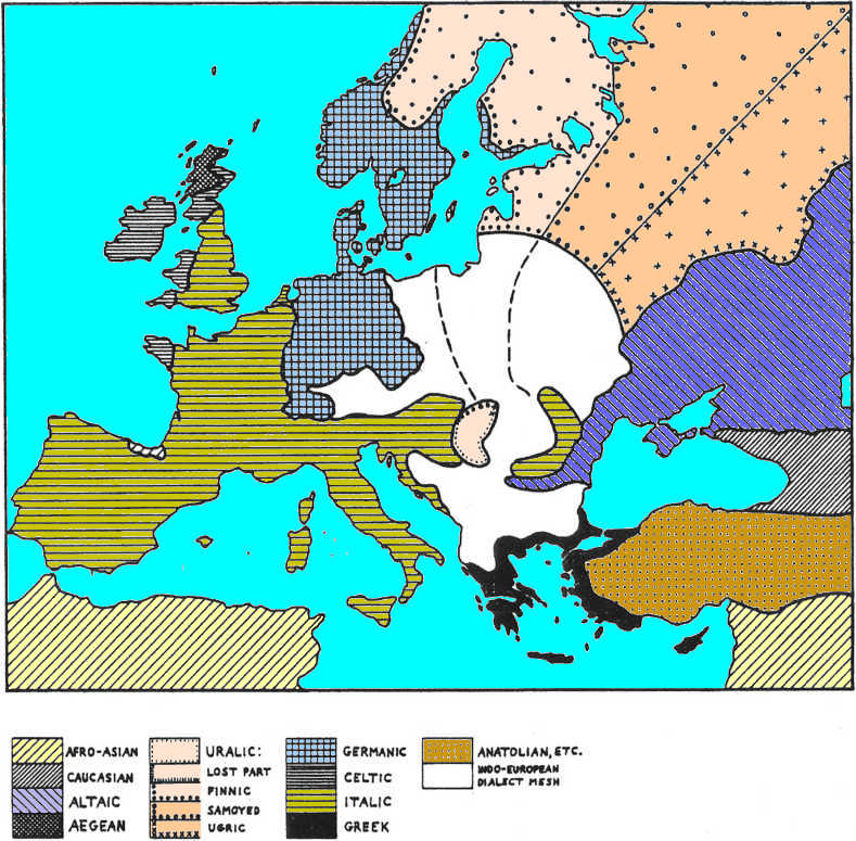

 3-Field System
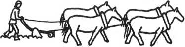 German Reflux
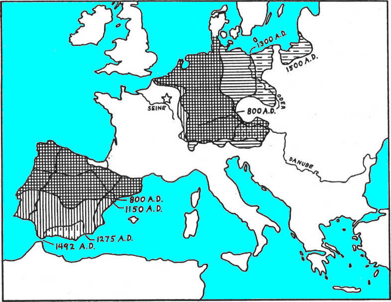
 Iberia
  During the next three and a half centuries their
expansion rate was twice as fast. There is no obvious ecological basis for the early part of this
Christian expansion, but the later and major part coincides with the German expansion to the east.
An obvious presumption would be that the 3-field system, horse collars, stirrups, and the rest of
the Feudal economy had taken hold in northern Iberia at this time. This then added greatly to the
population and military strength of this northern faction.
During the next three and a half centuries their
expansion rate was twice as fast. There is no obvious ecological basis for the early part of this
Christian expansion, but the later and major part coincides with the German expansion to the east.
An obvious presumption would be that the 3-field system, horse collars, stirrups, and the rest of
the Feudal economy had taken hold in northern Iberia at this time. This then added greatly to the
population and military strength of this northern faction. Other Places
 Recept Racial changes