CHAPTER FIVE — GERMANIC SHIFT
The first major break in the Indo-European dialect mesh, at least in Europe, resulted from the
Germanic expansion out of Scandinavia. This, and a few other events, inaugurated a series of
changes that totally broke up and redistributed the European language picture over the following two
thousand years.
Farming peoples have the ability to evacuate their homelands under adverse circumstances, while
hunters cannot. This is
possible because they can take in their last crop and move, taking this food-and-seed with them.
They also may have better information about where a more suitable environment might be
found. More important is their ability to concentrate in large
numbers for a move through a narrow space. This concentration can give them immediate military
superiority over almost any resistance. Of course, upon settling in a new area they must necessarily
disperse themselves to about the same degree as the local residents, and then their temporary
advantage is lost.
Simple migrations of farmers, into already farmed areas, are usually absorbed by the previous
residents within just a few centuries. If the intruders and residents share similar technologies,
economies, and cultural prestige, then it is just a matter of time and mate exchange until the more
numerous residents linguistically absorb the newcomers. Ordinarily, such intrusions number no more
than a few thousand, or maybe tens of thousands, of people moving into a region that is many times
more populous. Migrations of much larger numbers would be decimated by problems of sanitation and
disease if they were similarly concentrated. A very large migration might avoid such problems by
subdividing into many separate units. But these would usually be distributed in various directions,
each of which would ultimately meet the same fate of all other such smaller migrations.
100, 101
There are some special circumstances under which migrating peoples can and clearly have maintained
their ethnic identity indefinitely. If the group occupies an insular or peninsular location in which
it becomes the sole or major population, then it might persist. The physical absence or small number
of immediate neighbors might serve to insulate them against linguistic absorption.
The other circumstance is where the separate elements of a very large migration maintain
communication and close proximity to one another. In this manner they might divide the resident
population into relatively small groups between their own immigrant elements. Under ideal
circumstances it could be the divided groups of residents who become linguistically absorbed on a
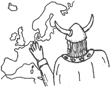
large scale. It was apparently a massive migration of just this kind out of Scandinavia that moved
into and created what eventually became Germany.
 Exodus from Sweden
The Sub-Atlantic phase of climatic deterioration in Europe was a relatively mild episode that
effected farming only along its northern fringe of greatest vulnerability. It probably was not even
noticed on most of the continent. Its major effect of cooler and damper climate
devastated the Scandinavian Peninsula; the East Baltic region apparently was not much bothered, but
this is disputed (Fodor 1976 vs Kivikoski 1967). The Sub-Atlantic spans the last five centuries BC.
During its most intense part, from 400 to 50 BC, Sweden almost disappears from the archeological
record (Pounds 1973:14, Scott 1977:9, and Stenberger 1962:109).
102
During the late Bronze Age, just before this episode, about one-third of present Sweden had been
occupied by farmers — with much of it very densely populated. The coast was occupied halfway up the
Gulf of Bothnia. The Norwegian coast was then held by Europeans (i.e.
farmers, linguistically presumed Germanic, genetic mixture unstated) as far north as Narvik. By 400 BC
Swedish occupation was reduced to just a thin coastal strip in the south, and the offshore islands.
Norway was almost emptied, and its coastal occupation drew back to near Bergen, at about the
latitude of Stockholm. Denmark does not appear to have been affected. (See Fig. 16 for the emptied
areas.)
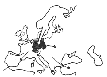
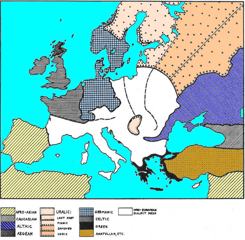
Fig. 16. Germania shift. Map A (left) shows the original distribution of Germanic in Scandinavia.
Open hatching shows the old area of Nordic speech — the sparse pastoralists who should have been
assimilated (by farmers? by local Mesolithics? By R1b Kurgans?) by 500 BC. To the south are the major German rivers beyond Denmark that would be the
goal of emigration from Scandinavia during colder, wetter times.
Map B (right) shows the result of the Sub-Atlantic phase, where continuing coastal occupation and
Denmark are given in tight hatching. Open hatching shows the area evacuated by farmers, and which
presumably remained only sparsely occupied.
The German rivers are drawn as solid bars 20 km wide — the presumed strips of earliest Scandinavian
intrusion (into R1b Celtic space). A fine line is drawn around the drainage area of these rivers. |
 |
The obvious conclusion is that nearly the entire population of Sweden, and most of Norway as well,
simply went away somewhere. These areas began to be repopulated after about 50 BC, presumably by
recovery from the fringe settlements and by new immigration, mainly from Denmark.
Other explanations have been offered for this lack of an archeological record for nearly four
centuries. The developing Iron Age on the continent at this time has been credited by some
authorities with cutting off the affected area from trade and communication, hence the scarcity of
datable remains (Stenberger 1962). I fail to understand why such a unique event as this cutoff
should have occurred here.
More seriously, some Swedish scholars I have talked to (but failed to note their names) think that
there are enough undated Bronze Age graves to fill the gap if they are mostly assigned to this time
period. This strikes me as dubious for two reasons.
The percentage of undatable graves ought to be roughly constant for all centuries, but we are to
suppose that they concentrate on just the afflicted time period. This is so odd as to require some
special explanation that is not forthcoming. Also, we do in
fact have a continuous record on the coast and islands where the material is clearly datable to the
otherwise empty period.
103, 104
We can safely proceed on the assumption that the major part of the Bronze Age population of Sweden
simply moved out. Being farmers rather than hunters, they had this option. It is also evident from
the record that they left rather abruptly — the entire exodus must have taken place in less than a
century. The only logical direction for them to go was south. It is tempting to see this event as
the origin of the German-speaking population on the continent. Before we can draw this conclusion it
is necessary to show that such a move is consistent with the rigorous approach used in the rest of
this reconstruction.
The recent German area, and especially the rough mapping of the earliest Germanic occupation here,
conforms closely with the combined drainage of the Rhine and Elbe Rivers, and the lesser rivers
between them. I will go further and postulate that this was exactly their initial area of intrusion.
The Oder drainage to the east, and the Vistula basin still farther east, may also have-been
invaded. Judging from the following calculations, and also from the later pattern of linguistic
events, it would appear that these eastern rivers received no more than minimal Germanic
immigration, which did not long persist.
|
The events close to the turn of the eras saw the spread of the Germanic people and Germanic
languages from the Baltic to the Black Sea and Balkans (Goths, Gets/Getae/Dacians), that created a huge Germanic area of control and
settlement in Eastern Europe in the previously nomadic territories occupied and dominated by the
Alan tribes and Thracian tribes. The Germanic area of the Rhine and Elbe rivers was only a part of the Germanic
migration. |
As Swedish Bronze Age agriculture was failing in the 5th Century BC, the affected people would
naturally be looking for more suitable lands to the south. They would have had enough geographical
knowledge at that time to know that warmer climates lay in this direction. They would also know that
the land in this direction was already occupied by settled farmers (and
horse pastoralist tribes of Sarmatian circle). There was enough time for
explorers to discover (if they didn't already know) that beyond the Danish area there were river
valleys that were not well populated. Most of the Celtics in the area of modern Germany farmed the
better-drained, lighter, upland soils away from the rivers (Pounds 1973), and some of the
Scandinavians would certainly know this. A major ecological opening was available at that time for a
population that was already oriented to exploit it.
105
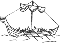
For transportation, Scandinavia was well supplied with large boats. These are well known,
indirectly, from two sources. Rock engravings and other art work of the Bronze Age show unmistakable
boats, often shown containing numerous men with oars. Of similar age are burial places or
monuments — patches of ground outlined with many upright stones in the shape of a ship. It is not
presumed that a ship was actually buried at such sites, but the size and shape of one is clearly
represented in each case. Most of these range from 6 m to 20 m in length, with a few measuring much
more (Stenberger 1962) (Typologically, the burials are clearly connected
with the R1b Kurgans).
There has been much discussion as to the construction of these ships, whether they were skin-covered
frames, or were solidly planked. The rock engravings have been interpreted by many authorities to
represent the wooden ribs of a ship showing through an ox-hide covering. A simple consideration of
their absolute size rules this out. Ever-larger ship frames can be made from timbers of increasing
sizes, but ox hides have a fixed thickness and strength. Beyond a few meters length, such a ship
would be so heavy that even a gentle scrape against shore gravel would tear through any hide.
Multiple layers of tanned animal skins only postpones the inevitable failure. While we do not yet
have actual remains of ships from exactly this time, there is one dated to the early 3rd Century
BC from Denmark. This specimen is 10 m long and is built of planks (Clark 1977:203).
Planked craft, much like the later Viking ships, would be capable of transporting large numbers of
people to new locations. Let us suppose a million such people are to be moved out of the southern
one-third of Sweden into the middle of the western German area in half a century.
The people would weigh an average of 60 kg (including infants and children) and may have had
baggage, equipment, and livestock of 240 kg each, for an estimated total of 300 kg per person.
(Modern refugees often move with only a small fraction of this weight.) A fair-sized Bronze Age ship
of 15 m could carry 15 to 20 metric tons of cargo, thus about 50 people with their possessions, and
a crew of perhaps ten.
106
At just walking speed, and moving by day only, such a ship could travel from central Sweden to
half-way up one of the German rivers and return in less than three months. (Some trips would be
longer, most shorter.) Two trips each summer and, allowing for bad weather days, just one winter
trip could easily be made by each ship. One fair-sized ship could then transport 150 people per year
to their new homes at a leisurely pace. In 50 years a million people could be transported this
distance by 133 such ships. If a thousand ships were available (a low estimate) this entire
population could have been moved in less than seven years.
Obviously, most of the existing ships would continue to be used for ordinary commercial purposes,
fishing, and war during this time. But then, Danish sources would probably have had at least an
equal number of ships that would have been available for this move, giving a total of maybe 2000
craft. In a 50-year period, the mass migration of a million heavily supplied people could have been
accomplished with the diversion of only about seven percent of the available sea transport.
The Swedish immigration into Germany need not be viewed as a military invasion. Rather, it would
have been more like a massive infiltration of settlers into the lightly occupied river valleys. Of
course if resistance were encountered, the intruders would have had overwhelming numbers of armed
men available at each of their limited paths of entry. These rivers would have been familiar to many
commercial shippers from the Denmark area, and no doubt to a few from Sweden and Norway as well.
They may also have been regularly visited and fished, with occasional settlers being introduced even
before this great migration.
The geographic pattern of the move is both simple and regular. Emigrants from Sweden might naturally
assume that a warmer climate was the general necessity, although it was only warmer summers that
were actually needed. They would accordingly have felt compelled to concentrate their intrusion into
those rivers located to the west of Denmark — to the east winters were just as cold as in southern
Sweden.
107
We can presume a limit to their adventurousness and the distances they were willing to travel, which
would also be based on their area of prior familiarity. This limit could be put at 200 km to either
side of the base of the Danish peninsula. To the east, in the least favored direction, this gives
them access to the coast and lesser streams, but stops short of the Oder river. To the west they
would enter the Elbe, the lesser rivers Weser and Ems, and reach into the Zuider Zee. Within this
sea they would have access to the Isel River (also Ysel or Ejssel) which is one of the mouths of the
Rhine. Progressing up the Isel they enter the main part of the Rhine upriver from its joining with
the Maas (Meuse) River. If they were consistent in moving only upriver, then the drainage of the
Maas would be omitted from their area of occupation. From this entry pattern we simply follow their
advance up every branch of each of these rivers to the limits of their drainage basins and stop
there.
During the Roman conquest of Gaul, and over the next few centuries, note was made of the
Celtic-Germanic boundary in much of this region. A few tribal assignments in Roman sources may be
incorrect, but generally the Germanic area reported at that time corresponds closely with the line
based on these drainage basins. My exclusion of the major mouths of the Rhine as well as the Maas
tributary was in fact originally suggested by this early mapping of the Germanic tribes. Only later
did I find this made perfect geographical sense.
 Occupation of Germany
At first glance it might seem that an exodus from just one-third of a small country like Sweden
could not possibly have overwhelmed the entire Celtic population of such a large area as modern
Germany. However, more careful examination of the details shows it to be quite
feasible, even inevitable.
|
In terms of predominant components of population, now Swedes are composed of Y-DNA Hg's I 34.6% (Europe Paleolithic),
R1a 20.2% (Nostratic A, in Europe since 8000 ybp), R1b 18.7% (Nostratic B, Celtic, in Europe since
4800 ybp); West Germans are now composed of Y-DNA Hg's I 37.5%, R1a 8.1%, R1b 47.9%; that indicates
that the 5th c. BC Europe Paleolithic/Celtic population blend on the continent largely remained in situ,
absorbing the Swede migrants without much displacement. The similarity of the genetic composition
before and after migration, after prior 2000 years of cohabitation, points to a Europe Paleolithic/Celtic
(proto-Germanic) linguistic mesh, a lingua franca that grew into the modern Germanic languages. The
continental R1b Kurgans from the east assimilated to the Germanic linguistic mesh, leaving
distinct linguistic traces of their impact.
The prior farming and non-farming population of the continent consisting of Hg's R1a and G2a was
decimated at about 2500 BC (4500 ybp) during the “killing fields” period, and the remains fled to
Eastern Europe, Caucasus, and Anatolia, establishing there new core areas of their presence, dated
to around 4500 ybp. During the period of 2500 BC (4500 ybp) - 1000 BC (3000 ybp), Europe was
predominantly populated by the R1b Kurgans from the south-west (Iberia) and from the east (Eastern
Europe) with their agglutinative languages. At around 1000 BC started a reverse flow of R1a
fugitives back to Europe, displacing and absorbing the Kurgans' Türkic and Celtic agglutinative
languages into newly formed European “Indo-European” flexive languages.
Prior to the New Age, the ethnic, genetical, and economic aspects of the populations were tightly
linked, with the permanent links entering the first literary sources. The R1b Kurgan ethnicities and
economy remained pastoral, militaristic, and mobile; G2a and R1a ethnicities and economy, after
their hunter-gatherer part dissipated, enduringly remained agricultural, sapless, and static. |
108
The land area of Sweden that was seriously farmed in the late Bronze Age, and then evacuated,
amounts to some 98,600 sq km by my measurements. In the 2nd Century AD it is estimated that the
northern part of this, called "central" Sweden, supported a population of at least half a million
people, at a density of something like ten per sq km. (Here and elsewhere I have used population
estimates from Pounds 1973.) This would involve half of the farmed part of Sweden. For the remainder
of settled Scandinavia, as well as for Germany, a density as low as five per sq km is indicated.
Seven centuries earlier (5th c. BC), Bronze-Age Sweden would have supported at least as many people. Their
settlement actually extended somewhat farther to the north at that time, as compared to the early
Iron Age (2nd c. AD), and there were no significant improvements in agriculture during this interval. Assuming
the same densities in 500 BC as for 700 years later (2nd c. AD), the other parts of Sweden and evacuated
Norway would have held another 472,500 people. Adding these to the population of central Sweden,
this gives us the potential for an exodus of 972,500 people. (I have not figured in the native
Scandinavian cattle herders of the interior, nor the coastal people to the north. Some of them may have been involved, but this is not certain. Probably they spread into the
evacuated areas.)
At six persons to each sq km in the defined basins of the Rhine and Elbe, a high estimate of the
target population in western Germany would be about 2,472,000 people in an area of
412,000 sq km. (Duby, 1973, estimates a population less than half this
great, but he no doubt would also have reduced the Swedish numbers correspondingly if he had dealt
with that area.) The residents should then outnumber the intruders by well over two to one; the
invaders having just 28.2% of the combined populations.
Casual examination of rivers and tributaries in the German area shows 6,275 km of total length of
significant streams that would be easily navigable for even the largest ships of the time. There is
also a northern coastline of 750 km that is of easy and immediate access. The likely scenario would be for these
infiltrating-invading Scandinavians first to occupy the coast and both banks of all these rivers to
an average depth of ten km in all directions. (The actual occupation zone would vary greatly from
place to place, but this may be used as an average for purposes of computation.) The area of these
shoreline strips adds up to a surprising 133,000 sq km, or 32.3% of the total.
(See Fig. 16 for a map of this initial area of occupation.) If the intruding population were spread
evenly over all this area, to the exclusion of the resident natives, their density would be 7.42 per
sq km. This is about the average for the entire source area, and is well under that estimated for
central Sweden.
109
This riverine zone of the German area was originally the least populated part; as noted above, the
higher lands were the most favored for their easy farming. If the density of native riverine
residents is taken as two per sq km, then some 266,000 people would be living in these strips. This
would be only 10.76% of the total Celtic population of the Rhine-Elbe basins, who were occupying
32.3% of the total land area.
It may be assumed that the infiltrating Scandinavians would absorb these people into their own
groups. Some residents might move away from the shores, while others would be attracted to the
newcomers, and these should about balance. The intruders'
972,500 would be augmented by the assimilation of these 266,000, for an immediate total of
1,238,500. In this first action in a limited area the intruders outnumbered the affected residents
by almost 4 to 1, so these could have been incorporated with no difficulty. This augmenting raises
the population density along these river strips to 9.3 per sq km — almost the same as back in central
Sweden, and a workable figure as will be seen.
After the subtraction of these 266,000 people, the remaining Celtics between the riverine zones
would number 2,206,000. They would be occupying a badly subdivided area of 279,000 sq km, with a
density of 7.9. At this point the remaining Celtics will still outnumber the intruding Germanics,
but the ratio is reduced to less than 2 to 1. Now the intruders have 32.3% of the land and within the whole river drainage area.
110
The number of rivers and their combined lengths that are used here is somewhat arbitrary. During
the first century of intrusion the riverine occupation may have been somewhat less than the total;
given time, the occupation could well exceed that calculated here. The rivers figured here are
simply those that are shown most regularly on various European maps. The 10-km distance from each
bank is based on an easy day's walk to the limit and back. The density of Celtic population along
these rivers was arbitrarily set at just one-third of the average reported for the entire country.
This riverine population density would then be one-fourth of the density in the remaining higher
lands where most of the farming was concentrated. It just happened to work out that when the
resident Celtics of the rivers are added to the Scandinavian intruders, their total would fill these
strips to almost the ten per sq km, just as in the best Swedish lands.
The ecological basis for this newly achieved, high density of riverine settlement must also be
considered. Some explanation is needed for the Swedish population here being about four times
greater than it was for the natives before they arrived. The two obvious means are fishing and
short-term crops.
Fishing skills were increasingly developed as Indo-European farmers expanded to the north.
Dietarily essential vitamin D for winter consumption was obtained from sun-dried fish. Water craft
and other appropriate fishing technology were devised and adopted from resident hunters, as well as
from the Aegean Boat People who were encountered there. Most of the ships from the affected Swedish
and Norwegian areas would ultimately end up in Germany, along with the skills to build more. The
German river system offered an underutilized ecological opportunity to exploit this large aquatic
food supply. This developmental gap eventually would have been closed by a slow filtering to the
south of the appropriate skills, and this was no doubt underway. But the process was fortuitously
accelerated by the climatic adjustment that drove large numbers of skilled fishermen into the area during one short time period.
111
Scandinavian farmers had long been situated up against the limit of the 120-day growing season. This
limit is somewhat arbitrary because it depends on the crop, and fluctuates from year to year. Still,
it marks the approximate limit of farming that was reached by the first settlers around 3000 BC.
Yearly variations in the length of the growing season would have adversely affected crop yields on
many occasions. This problem would be most frequent near this upper limiting line, but at times it
would have affected the greater part of inhabited Sweden and Norway. In bad seasons often only part
of the grain crop would mature. This would cause a strong natural selection favoring those
variations that matured slightly early; conscious selection by the farmers is not required. The
automatic result of short-season varieties may also be at the cost of losing some other desirable qualities.
Seed from these fast-growing strains would have been brought by the settlers into the German area
and would be sown in the river valleys. The German rivers, especially the Rhine, have a spring
flooding as they drain meltwater from the snowfall in higher altitude areas to the south.
Accordingly, their bottomlands cannot be tilled and sown until much later in the season than the
surrounding uplands. This results in a growing season that was too short for the Celtic farmers to
use.
However, selected northern seed was better able to mature in the available time. Scandinavians were
able to take large yields from this unusually fertile soil. Again, the techniques and seed might
eventually have filtered down to this area, but it was a climatic shift that brought them in
abruptly at this time.
Celtic and Germanic peoples would find their respective territories interfingered in a complex
pattern, with each group of one ethnic type partially surrounded by groups of the other. With total
population figures for the entire region still running almost 2 to 1 in favor of the Celtics, they
eventually would have assimilated the Germanics if all other factors were equal.
Several additional factors tipped the balance in favor of the Germanics. (Throughout this discussion I often use "Germanics" for Germanic-speaking people,
"Celtics" for Celtic speakers, and so on, for easy flow in the narrative. I am sorry if this
shorthand form bothers some readers.)
112
The scenario of intrusion given here is somewhat artificial for the sake of simple presentation. I
have described how the river zones were occupied as a first stage, which was followed by the taking
of the intervening higher lands. Actually, many of these between-river spaces in the north would
have been taken early in the movement, and long before the river zones were filled in their more
distant southern parts. The actual process of filling in between the rivers was probably progressing
as a "second front" a few hundred km behind the advance wave up the rivers themselves. The time
taken to evacuate Sweden also imposes some constraints on this model.
If the evacuation was accomplished in 50 years, there had to be enough land available at the end of
this time to support all these people. If the riverine settlements had progressed just half of the
600 km straight-line distance through Germany in these 50 years, they would have acquired 66,500 sq
km of river zone territory. The invaders’ full 972,500 people, plus 133,000 from half of the Celtic
riverine population that would be incorporated at this point, add up to 1,105,500 Germanics
(The genetic composition shows that transition was smooth, and that is
reflected in the Classical writings, with the blurred difference between Germanics and Celtics is still
being chewed over by the modern scholars). At the
previously calculated density of 9.3 per sq km, only 609,150 of these could be settled in the
partially occupied river zones. The other 496,350 must be settled in other places. At the assumed
upland density of 7.9 per sq km (as with the Celtic farmers), another 62,800 sq km are needed to
locate the rest of the Germanics. In order to take this much territory the full Germanic advance
over the land area must have moved almost 150 km, or one-fourth of the total distance. Out of a
total linear distance of 600 km, if the riverine advance had reached 300 km in 50 years, the total
occupation must have gone half of that, or 150 km.
A new aspect to the intrusion now appears in the above version of upland occupation following
shortly behind the
riverine expansion. No provision was made for the Celtic population that had been living on these
uplands. Many Germanics would have been lost in the inevitable wars, and others lost through
temporarily strained refugee living conditions. Their places would have been filled by many
thousands of Germanized Celts. I cannot imagine that any more than half of these upland Celtics
would have been incorporated into the Germanic ranks.
That still leaves the other half with nowhere to go but out.
The exodus of these Celtics is discussed in the next section.
113
Something like this double pattern of advance is probably close to what actually happened. The
advance wave of riverine occupation would eventually absorb and Germanize all of the
266.000 Celtics who lived there. The second wave of upland occupation
that followed behind would Germanize about half of the Celtic inhabitants (ultimately 1,103,000
people) over a protracted period of time, and force the departure of the other half.
The numbers involved can now be reviewed in terms of the originally described two-stage occupation
of Germany. The initial riverine occupation by 972,500 Scandinavians would absorb
266,000 natives and become a population of 1,238,500. These would then
assault the upland Celtics in a piecemeal fashion and eventually absorb 1,103,000 of them in modest
increments. This leaves 2,341,500 Germanic people in a previously Celtic land, while another
1,103,000 of these Celtics have gone elsewhere under pressure. It still remains to be explained why
the invaders should have prevailed over the residents so often that such an impressive Celtic
withdrawal would have occurred.
River shipping of large volumes of produce gives a significant economic advantage to those with the
equipment and locations to accomplish it. They can also transport large populations both up and down
the rivers as circumstances call for. Military reversals in local conflicts need not be total for
those, who have ships. The simple expedient of crossing a river can often provide a safe retreat — an
opportunity that is denied to land-based foes under comparable circumstances.
It can safely be presumed that the recent mass migration out of Scandinavia and the continuing
upriver settling would mean these people had a degree of cooperation and coordination far greater
than that found on the Celtic side (Celtic side was on both sides). Finally, there is the simple fact that these northerners were
bigger and stronger, on the average, than their Celtic adversaries. In combat with hand weapons this
gives a substantial advantage to one side, all else being equal. The effects of a similar body-size
discrepancy between Celtics and the still smaller Mediterraneans were often noted by classical
writers among the latter (which allows to think that not much difference in
body size was between two Celtic sides). Absolute body size in this part of the world varies with latitude in a
regular geographic manner.
It must be stressed that the details given here of exact land areas, populations, and densities are
actually only approximate. The succession of events is also not necessarily exact. This picture is
built up from the most probable parts known, and the result is not only inevitable, but it accords
well with historical facts that were recorded by civilized people around the edges. Details might
well have varied, but the general picture is probably true as given here. The most precise, and
hopefully testable, prediction here is that German ultimately relates more closely to ancient
Swedish than it does to Danish (Danes with Y-DNA Hg's I 38.7%, R1a 16.7%,
R1b 41.7%, E1b1b 2.9% little differ from the Germanics and Swedes).
The numbers and distributions of ethnic forces given here would have been just barely sufficient to
ensure ultimate Germanic dominance of the Elbe-Rhine drainage basins. Another factor that probably
contributed to their success was the sparse population of the region surrounding the Low Countries.
The presense of non-Germanic and non-Celtic place names here indicates that it must have been
ill-filled in the first wave of Neolithic settlement. Barraclough (1978:85) maps this area as
including the coastal 30.3% of the drainage basins under consideration here. If we assume this place
held just half the number of people as in other Celtic areas, then an across-the- board reduction of
15.2% can be made. Applying this correction factor throughout all the previous calculations would
mean that
the initial riverine zone of Scandinavian occupation would have contained 39% of the total drainage
basin population. If the previously calculated 35% was sufficient, then this likely 39% makes their
success even more understandable.
115
A large ethnic group of native Mesolithic people (reference to Y-DNA
Hg's I) continued to exist as cattle herders for some time
in the interior of the southern part of the Scandinavian peninsula. We do not know exactly when
these (Y-DNA
Hg's I) Nordics were assimilated into the Germanic agricultural population. If they still existed as a
separate entity at the time of the evacuation of Swedish farmers, they could have expanded to fill
some of that void. (Remaining Swedes, reverting to a Mesolithic economy with some pastoralism, could
have filled it just as easily. Lappish reindeer herders may also have temporarily extended their area.)
It is much more likely that these Nordic natives were absorbed into the Germanic speech community
well before this time of exodus. These people are the only obvious source of the non-Indo-European
vocabulary found in the Germanic languages. Since this includes German itself, the absorption must
have occurred before the southward move began in 500 BC.
|
The obvious sources for the non-Indo-European vocabulary found in the Germanic languages are the
Nostratic A (R1a) and Nostratic B (R1b) agglutinative languages, which probably diverged to a degree
of being mutually incomprehensible, and then the unknown language of Hg I, which was demographically
minor, and socially indistinct. This is consistent with the etymological studies, when the pseudo-IE
bias is abandoned, and the Türkic, especially the northern Türkic, is considered. |
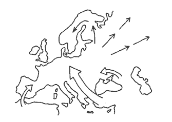
 Celtic Diaspora
According to many prehistoric reconstructions a great expansion of Celtic peoples began about 800
BC. This was supposedly because of their military and commercial power that was based on the
ironworking in their central European homeland. Archeological evidence of the spread of Hallstatt
iron work was probably just that — and no human movement need be supposed. Only after 500 BC is
there clear indication of human migrations, and their explanation given here turns out to be quite
different from the usual image of a conquering ethnic group. An ethnic expansion of the Celtics is
no more logical than the supposed ethnic spread of the Kurgans out of the Pontic Steppes.
|
The R1b Celtic expansion started not in 800 BC, but in 4800 ybp (2800 BC) from Gibraltar, and as
Beaker Culture spread along the Atlantic seaboard, western European river network, across Pyrenees
to a part of the Apennines, and to the Mediterranean Sea islands. Another Kurgan intrusion of the
same R1b Kurgans came overland from the from the Pontic steppes (Altaics). They took Europe by
storm, wasted plenty of the locals, causing almost all Old Europe haplogroups to disappear, while
some were able to escape: Hg R1a to the Eastern European plain, Hg G2a via Asia Minor
to Mesopotamia and Caucasus, Hg E1b to the Balkans and North Africa, Hg I1 to in
Scandinavia and British Isles, Hg I2a1b to the Eastern Europe and British Isles. By
4000 ybp (2000 BC) the new order stabilized and continued for about a millennium or 40 generations,
when a new tumultuous period again changed ethnolinguistic, genetic and economic map of Europe. The
presumed idyllic linguistic stability from the 7000 BC to the 800 or 500 BC not only did not exist,
but the wipeout and massive displacement of the population was no idyllic. |
116
During the intrusion of Scandinavian immigrants into central Europe large numbers of the Celtic
natives evidently left this area. The entire Rhine through Elbe drainage basins has an area of
412,000 sq km, and was then the home of about 2,472,000 people. The considerations developed above
indicate that nearly half of this population, an estimated 1,103,000 people, departed under pressure
within the period of 450 to 50 BC. Massive movements of Celtics were noted by Roman and other
historians during this same time. These migrations clearly stemmed from a source generally in the
German area, just as postulated here. While some authorities assume they are refugees fleeing from
advancing Germanics, many others see this as part of an overall Celtic expansion on its own merits.
There are no natural factors that would appear to support this latter interpretation.
A ’’domino" effect is described here where Scandinavians make one shift, and this causes Celtics to
make the second. The lasting effects of these two moves, however, are totally different. A presumed
972,500 Scandinavians made a concentrated move in one direction into a clearly deliminated
(delimitated)
territory. The circumstances were such that the ethnic composition of these intruders would be
preserved and was automatically imposed on those of the fragmented resident populations that
remained. The exodus of 1,103,000 Celtics was dispersed to the west, south, and east, in at least
six identifiable groups. They were locally successful in conquering pieces of territory and
maintaining their ethnic identity for some time. In the long run, however, their dispersion was too
wide-spread for any of them to have preserved their languages longer than about four centuries.
|
Stating a factual loss of Celtic languages in foreign milieu in 400 years (16 generations) conflicts
with the presumed stability of the Celtic languages for 6500 years (260 generations), or even for
the actual period of 2300 years (92 generations), given that the Iberian Celts in the 5th mill. BC
quickly dispersed over most of the Western and Central Europe, manyfold diluting their partial
presence. Under such dispersion, no wonder that by 500 BC Celtic morphed and assimilated into
numerous individual languages. Demographically, the splits of the 5th mill. BC produced individual
divisions incompatibly smaller that the 100,000 groupings suggested for the 500 BC dispersion. The
Celtic 5th mill. BC density and grouping theoretically should be consistent with the densities and
grouping suggested in this study for the pastoral economies, with the same linguistic consequences. |
If we assume these Celtics left in only the six groups identified here (an unlikely assumption),
they each could have numbered 184,000 people. More likely, these six groups were only about half
this large, while the remainder was distributed in many smaller movements. A wide dispersal of so
many groups, some of them very large and others small, could easily create the impression of an expanding ethnic type. This is especially true if they were militarily powerful,
and if their spread was accompanied by the diffusion of advanced ironworking techniques. The actual
cause of this movement has been obscured by the fact that historical sources were often so situated
as to observe the Celtics, but largely missed the driving force behind them.
117
The Belgae of northernmost Gaul were noted by Caesar in the middle of the First Century BC, and he
was told that they had recently come from the region of Germany. These were Celtic people, in large
numbers, who had also entered Britain by that time. The area in question of northern Gaul should
have supported a minimum population of 450,000 at six per sq km.
118
Obviously, even a full one-sixth part of the Celtic dispersal (184,000 people) would have
constituted no more than a rather influential, and possibly a conquering, force. They apparently did
not have the benefit of any major new technology, nor any unique geographical circumstances, that
would have enabled them to make an ethnic replacement in settled agricultural regions.
But is is possible that they were the first Indo-European farmers to occupy some parts of the Low
Countries that up to then had remained in Mesolithic hands. In most of both Gaul and Britain they
should have made little difference because the previous residents were also Celtics.
|
The farming economy of the Celts is presumptuous. Celts arrived to Europe when areas of their
expansion were already occupied by farmers. Under those circumstances the migrant Celts had to
displace farmers, or more peacefully adopt vacant lands for their pastures. Kurgans did only
supplementary farming. |
Similar intrusions are known to have occurred in Iberia in the 5th Century BC. These would
therefore have been among the earliest Celtic groups leaving the German area. They are known from
place names to have settled in various locations over half of the peninsula. The resultant ethnic
mix is sometimes called Celto-Iberians or Celtiberians. Only in the northwestern corner did their
language apparently persist until Roman times where it
formed a distinct dialect after Latinization. This corner, still known as Galicia, was
semi-protected from linguistic assimilation by the fact that there were no neighbors along half of
its boundary. Assuming the Celtics entered Iberia around both ends of the Pyrenees, we could count
these as two of the six major groups that exited from Germany.
|
To begin with, it is not known if Celts completely abandoned Iberia when they started their spread
out shortly (200 years of 8 generations) after they crossed strait of Gibraltar. Genetic markers
indicate otherwise. |
Also in the 5th Century BC a massive Celtic intrusion occurred in the Po valley of northern Italy.
This was previously a thinly settled area, and these "Cisalpine Gauls" were a powerful force. They
were suppressed by the Romans some 400 years later, and ultimately assimilated.
|
The Celtic horde occupied unsuitable for agriculture Po valley in the beginning of 5th c. BC. They
joined the local Celtic kinfolks Insubres, who took the inhospitable valley in the 7th c. BC. The
5th c. BC newcomer tribes were Boii, Taurini, and Cenomani. In Türkic, Boii and Taurini (Taurisci) mean “occupier,
subjugator ~ warrior in IE perception” and “Mountaineer” respectively; Kelti means “Newcomer,
Newbie, Freshman, New Arrival”. Cenomani ~ Kenoman in Türkic may be “Kindred People”, same word as
in Hun = “kin, kindred”. The Po valley area gained a moniker Veneto from warlike Venetics ~ Wends ~ Wendeln = “Wonderers,
Nomads” in Germanic. The Po valley Celts raided and burnt Rome in 390 BC, another typical nomadic
trait of subjugating or punishing raids for not honoring tribute agreement. The whole story,
numerously relayed by Cicero, Polybius, Livy, Pliny the Elder, Strabo and Caecilius Statius, refers to
Celtic pastoral warrior tribes, with no hint of agriculture economy. |
Part of southern
Poland (mostly in Ukraine) is still known as Galicia from the ancient Gauls, or Celtic settlers from the same diaspora.
The Galatians of central Anatolia were well known to Christian missionaries of the First Century
AD. They supposedly arrived early in the 3rd Century BC, and eventually disappeared as a
linguistic entity.
The movements into Italy, Poland, and Anatolia may be considered as three of the
six major Celtic migrations. (See Fig. 17 for a map of all six.) If this reconstruction of events is
correct, the absence of many more migrating Celtic groups should become increasingly conspicuous.
119
|
Fig. 17. Celtic Diaspora. The German river basins, from Rhine to Elbe, are included in the
Germanic hatched pattern. Major groups of historically known Celts are named and marked with close
horizontal lines. These are interpreted here more as refugees than as a conquering expansion. |
 |
While this Celtic dispersal apparently involved a slightly larger population than the initial
Scandinavian intrusion that ultimately forced them out, they left no more than indirect linguistic
evidence of their fate. They do not appear on my language maps that summarize each time period. The
predictable geographical and technological circumstances that assured Scandinavian success on the
continent were equally definitive in leading to the ultimate disappearance of these migrating
Celtics.
 Language
Map
Language
Map
Linguistic distributions in Europe at the end of this phase of Germanic migration overlap somewhat
with the changes that are introduced by the next major event, the Roman Empire. These two events can
be separated arbitrarily at the year One (Fig.
18). This assumes the Germanic move was complete, and that Sweden and Norway were repopulated — these
were not quite true at that time. It also assumes that Latin had not yet supplanted any of the
languages that it later did, though this was actually beginning to happen.
|
Fig. 18. Language map in the year one. The Germanic expansion onto the continent has created a
strong boundary against other Indo-European dialects, thus allowing them free linguistic drift. The
Germanic move also cut-off western Celtics from their dialect chain and initiated their free drift.
Greek expansion followed a similar pattern, cutting off the Anatolians and themselves to drift. All
other areas remain constant. |
 |
The map differs in just a few particulars from that of a few thousand years earlier. These can be
mentioned in their logical, and somewhat temporal, order of priority.
The separate ethnic group of cattle herders in Scandinavia is gone. These Nordics almost certainly
had merged with the northernmost Indo-Europeans before the Germanic move began in 500 BC. This
would represent the beginning of the Germanic separation which Lockwood (1969) argues must have
occurred in a small area in relative isolation from the rest of Indo-European.
120, 121
The Germanic expansion onto the continent changed their
boundary from what may have been only a dialect transition into that of a fully bounded language.
From this time on, its own dialect mesh drifts independently of the rest of the Indo-Europeans.
This may have been the first break in the dialect mesh of the original Indo-European spread.
When the Germanic expansion reached the Alps it cut off the western Celtics from all contact with
the rest of the Indo- European mesh. This continuity had previously been maintained by a chain of
dialects around the eastern Alps. The language line across southern France could no longer be
circumvented, and Celtic also becomes free to drift on its own course.
For some three centuries Greek had been the socially dominant language of the eastern Mediterranean
and was being adopted by various peoples around the Aegean and up the Balkan Peninsula. This amounts
to a folding back of one language over several dialects, though by adoption rather than by human
replacement. It is clear that Greek had acquired linguistic independence from the rest of
Indo-European by this time. Of course the Greek of Linear B was distinct from written Hittite a
thousand years before, but the possibility of a chain of connecting dialects of nonliterate peoples
between them at this time cannot easily be dismissed. Greek expansion also served to separate the
original Indo-European mesh into its Asian and European halves and set them free to drift
independently of one another. While little attention is called to this Greek phenomenon, it is
actually a small version of the next major event that centers on Rome. Greek certainly had a much
wider distribution in the cities of the eastern Mediterranean than is shown here, but it is
primarily the rural speech that is estimated in this map.
The category "Anatolian" continues to be used for all the Indo-European languages of Asia without
distinguishing the Iranian area.
Other language breaks might have been created in the Balkans by the repeated incursions of Kurgan
horsemen out of the Ukraine. These are known from archeological records going back to well
over 4000 BC, and are here assumed to have been made by Altaic speakers. Domestication of the
horse enhanced the military capacity of these people, but it would not have increased their
population, nor in any other way enable them to make ethnic conversions. I am now inclined to think
that the Indo-European dialect mesh survived their activities in good order
122


 Population Mixing
 Anatolian-European
Mixture
Anatolian-European
Mixture Caucasoid-Mongoloid
Mixture
Caucasoid-Mongoloid
Mixture
