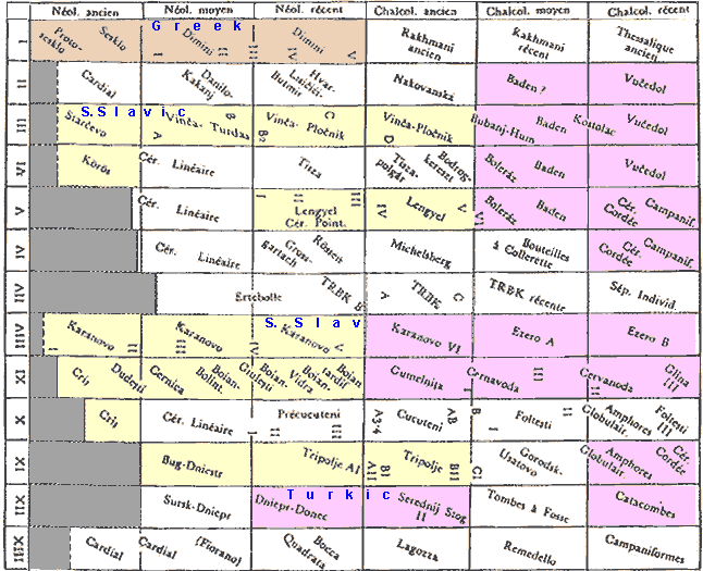
CHAPTER THREE — NEOLITHIC SPREAD IN EUROPE
The major thrust of the Neolithic (i.e. farming) entry into
the main body of Europe can now be described. Four simultaneous flanking movements of other language
groups have already been dealt with: Afro-Asian sweeping across North Africa and into Iberia,
Caucasian into the southeastern corner
(southwestern corner presumably was not Caucasian), Altaic
throughout the Pontic Steppes, and Aegean along the southern and western coasts of Europe. A fifth
flanking movement of Uralics in the north does not get underway until after the
(presumed) Indo-European entry, so its full description is postponed to the end of this
chapter.
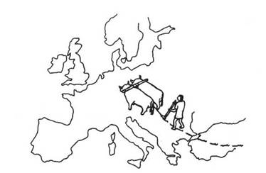
The overwhelming source of Neolithic farming in Europe is clearly the initial wave of immigrants
from Anatolia who first entered the Balkan Peninsula about 7100 BC. Their identification as
Indo-European speakers has already been discussed. Within a century of this entry the first-occupied
lands would have been filled to carrying capacity with settlers, and further immigration was quickly
phased out. This is the same pattern as with all frontier advances. It is mentioned here only to
remind the reader that there was no need for the existence of a great population reservoir in
Anatolia to feed into Europe. The initial wave of immigrant farmers is sufficient, and is all that
could have entered anyway.
55
Balkans
 Expanding overland
at a regular rate the (presumed) Indo-European farmers would
have fanned out uniformly over the southern Balkans. To the north they reached the deep-soil region
in northern Bulgaria at 6830 BC, where they met the Altaic sheep herders who arrived there at about
the same time from the opposite direction. Details of this encounter are given in the preceding
chapter. The immediate significance is that the entire Pontic Steppe region was then closed to entry
by any other ethnic group. The boundary of deep soils and grasslands, along with its inhabitants,
forms a right flank bordering the (presumed) original
Indo-European speech area on this continent.
Expanding overland
at a regular rate the (presumed) Indo-European farmers would
have fanned out uniformly over the southern Balkans. To the north they reached the deep-soil region
in northern Bulgaria at 6830 BC, where they met the Altaic sheep herders who arrived there at about
the same time from the opposite direction. Details of this encounter are given in the preceding
chapter. The immediate significance is that the entire Pontic Steppe region was then closed to entry
by any other ethnic group. The boundary of deep soils and grasslands, along with its inhabitants,
forms a right flank bordering the (presumed) original
Indo-European speech area on this continent.
|
The only archeological site in Bulgaria dated to Middle Paleolithic period (~10000–7000 BC) near
Varna contained flint microliths, indicating Mesolithic technology. That is consistent with the
arrival of Mesolithic people from Anatolia. The first polished Neolithic stone tools in Bulgaria are
associated with Eneolithic Age (Copper Age, 5000 BC on), independent from the rise of the farming. |
To the west and south the farmers spread over and occupied the major parts of modern Greece,
reaching its southern tip at 6500 BC. Differentiation of the Greek language must have had its
ultimate beginning at this time. There is no subsequent event that affords anywhere near this degree
of population replacement.
|
The whole written history of Greek language numbers 3400 years, that it our actual linguistic
horizon. We know of population movements concerning Greeks starting from about that time. We do not
know if Greek language existed 5000 years before that, and know nothing about those 5000 years of
linguistic history. |
Further expansion in the Balkans would then begin to encounter factors of winter cold and
shortened daylight hours, as described in the Rules of Movement. These would seriously affect the
intruding farmers in the form of personnel losses from the new climatic factors, local carnivores,
and the Mesolithic natives, among other things. The influence of these penalties may be noted on the
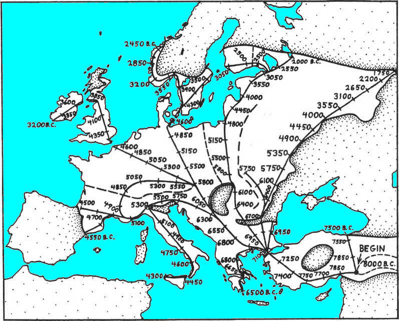
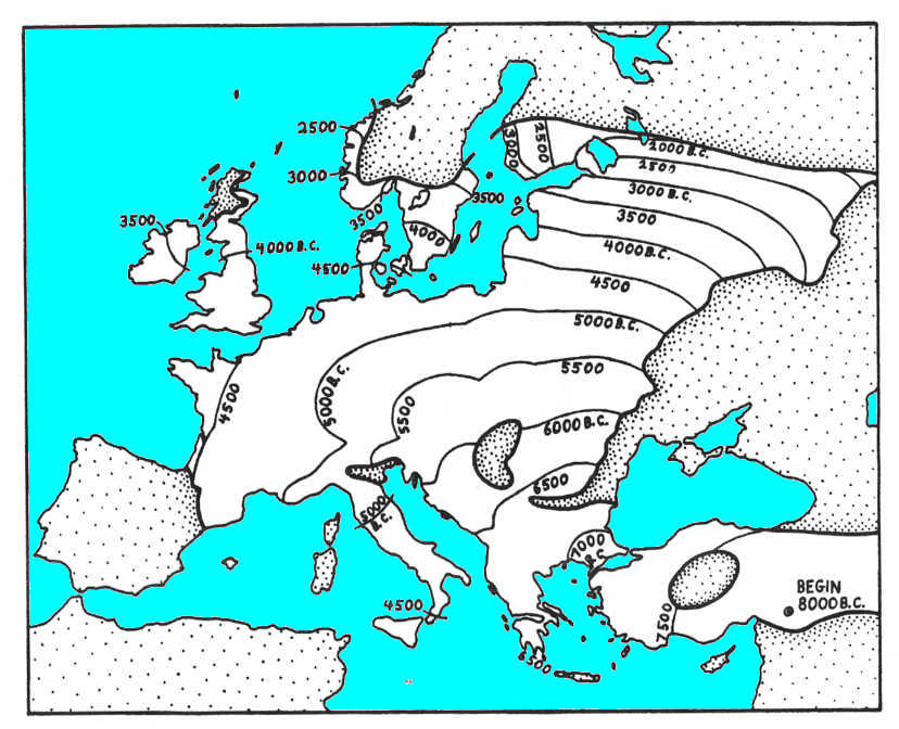
map of progress along the major routes where dates are given at each 200-km interval (Fig. 10).
This becomes even more evident on the map where the advance of the Neolithic
(i.e. farming) frontier is shown in 500-year intervals (Fig. 11).
|
Fig. 10. Neolithic (i.e. farming) expansion from Anatolia.
Heavy lines trace the main routes of (presumed) Indo-European
spread through Asia Minor and over the central part of Europe. Dates are given at each 200-km unit
of progress. (Presumed) Indo-European territory, along with that
of the Uralic farmers, is left blank; all other speech areas are stippled. Heavy dashed lines show
linguistic divisions where incoming peoples were partially separated by natural barriers. |
 |
|
Fig. 11. Rate of Neolithic (i.e. farming) expansion. The
farming frontier in Europe is shown at 500-year intervals from its inception in Anatolia at 8000 BC.
The contours are drawn from data given in Fig. 10 and from many more routes of spread that
were also calculated. This map compares favorably with calibrated dates of the earliest farming
sites, but this is because the advance rates were chosen partly with this goal in mind. The map
omits the Neolithic (i.e. farming) of the Mediterranean that was
spread by the Aegean Boat People only after their initial wave. |
 |
The advancing wave of farmers would first encounter the Hungarian Plain, roughly the eastern half
of modern Hungary, at 6400 BC. The deep soils here cannot be plowed except for some choice locations
mainly along the rivers. The Neolithic (i.e. farming) wave
became divided into two fronts that passed around each side of this area. Natives of the Hungarian
Plain would now have the opportunity to adopt domestic animals, among other things, from their new
neighbors. At this time cattle were included among these animals; they apparently were domesticated
in the southern Balkans just a century or so previously (Wenke 1980). Cattle would have gained rapid
popularity because they could be used to pull plows, as well as provide meat, milk, and tough hides.
(Cattle from Balkans to Scandinavia via Sea Shepherds?)
56, 57
Cattle are well adapted to the European forest zone, and wild forms lived there as part of the
natural fauna. Sheep, on the other hand, are not well adapted to forest conditions and had no wild
representatives in this area. Farmers can continue keeping sheep in Europe by clearing pasturage and
otherwise caring for and protecting them. Pastoralists would often find cattle to be the more useful
animal to keep under domestication here. The only advantage of sheep is to use their hair and skins
for clothing. It would be automatic for the Hungarian natives to adopt the pastoral aspect of the
Neolithic (i.e. farming) economy, with an emphasis on cattle,
along with pottery and whatever else may have seemed useful. They would have taken up little or no
farming, and no doubt put less emphasis on permanent dwellings and large amounts of personal
property.
As cattle herders these eastern Hungarian natives would then spread out automatically into all
available areas that were not already blocked by the advancing farmers. Their rate of advance would
be twice that of farmers, just as with the sheep herders of the Eurasian grasslands. By 5800 BC the
farming frontier would have passed completely around the Hungarian Plain with the two arms of this
advance meeting on its northern side. This then cut off the inhabitants of the plain from further
contact with their ethnic relatives who had spread out from there to the north and north-east. These
cattle herders on the outside, expanding faster than the farmers, would continually outdistance them
and come to occupy ever larger territories. The detailed history (with maps) of this advance of
herders out of the Hungarian Plain is given in a later section.
|
It appears that the “cattle” in this discourse is cows. By 5800 BC Pannonia would have been
encircled, and the choice of the animal herds was sheep, goats, and cows; no direct evidence for
mounted horse riding exists prior to 4500 (Bohai in Middle Asia), and the indirect evidence for
horse pastoralism comes only from the dietary refuse in the Eastern Europe. Sheep and cows imply
domestic pasturing, since they are not able to move over large distances. Aside from the nomadic
Turkics and Hungarians (Magyars), the term cattle in this discourse means cows. |
The domestication of cattle had been so recent in the Balkans that it probably would not have
spread far when the Hungarian natives picked up the practice. Cattle raising should have reached the
deep soils of eastern Romania at a similar time. Here they would be adopted by the local
pastoralists where they largely replaced sheep in this economy. This new domesticate would then
spread eastward over the Eurasian grasslands. In areas of taller grass, cattle would predominate; in
areas of less rainfall and shorter grass, sheep would continue to be the major domestic animal.
58
A two-part wave of cattle domestication then automatically spread eastward out of the Balkan
area. South of the forest zone, cattle were largely substituted for sheep by the existing
pastoralists, in place. Within the forest zone, cattle were introduced as the major domestic animal
by the influx of the first pastoralists out of Hungary. It may be assumed that cattle replacement in
the steppes progressed at about the same rate as the new pastoralists advanced in the forests.
Evidently neither got far enough ahead of the other to cross the forest line and make a major ethnic
intrusion into the other's area.
Continuing to follow the full Neolithic (i.e. farming)
advance we may note that the meeting point north of the Hungarian Plain represents a 600-year
separation of these two waves of farmers. This is not enough time for their speech to become
separate languages, but a strong dialect contrast would probably exist by that time. As people
advance at known rates from both sides, this meeting point would be extended into a meeting line
that can be plotted with some accuracy. It runs to the north-west, curves gradually toward the north
because those on the west move faster, and reaches the Baltic about 100 km west of the mouth of the
Vistula (54.2°N 19.4°E) (Fig. 10) .
The continuity of the spreading dialect mesh of (presumed)
Indo-European was broken by this line, especially to the north. It would not have been a major
linguistic barrier initially, but as speech innovations emerged on each side some might cross and
others might not, and it would have strengthened over time. The continuity from one side of this
line to the other would still exist through contacts around the southern side of the Hungarian
Plain. This would tend to limit the amount of divergence between the two sides in the north. From
its location and early occurrence, this may be taken as the dividing line between the original
Balto-Slavic in the east and Celtic in the west.
|
Since Celtic appeared only much later, after circum-Mediterranean anabasis of the R1b (modern
haplogroup R1b1b2 ) people, in ca. 4800 ybp, the “Celtic” here must be something else. “The peopling
of the Europe by the carriers of the haplogroup R1b1b2, who were speaking ancient Türkic languages,
occurred between 4,500 and 3,600 years ago. They are the ancestors of the Proto-Celtics and
Proto-Italics, and, probably, Proto-Picts and other “Proto”-R1b1b2 peoples in Europe... by the 6
thousand years ago the carriers of the haplogroup I, divided into two main subgroups I1 and I2,
lived in Europe for more than 30 thousand years... Approximately 4,500-4,000 years ago... haplogroup
R1a1 virtually disappeared from the Europe. As, incidentally, at the same time also disappeared
haplogroup I1 and largely the haplogroup I2.” [Anatole
A. Klyosov, 2010] From this genetical outline can be deduced that “Celtic in the west” was
potentially associated with I1, I2, or R1a1 people, of unknown languages. |
59
Eastern Europe
The spread of Neolithic farming in eastern Europe involves the entire area between the
(positively non-) Celtic meeting line on the west and the Altaic
pastoralists on the southeastern border. Within this area of expansion there are two crosscutting
divisions — earlier and later phases, and separate paths of advance. The two are described here in
that order.
The early phase is that of the (presumed) Indo-European
farmers who can be followed across the entire eastern front, disregarding the separate paths. At
their beginning these eastern farmers crossed from Bulgaria to Romania over a band of steppe land
along the lower Danube, most of which could not be farmed by simple techniques. It was a narrow
strip that was just then being infiltrated by the first Altaic sheep herders, and should have been
passed over with little difficulty or delay.
Farther to the north the farmers' advance rate gradually slows down with increasing penalties
from colder winters with shorter days. This eventually results in a halt of the ethnic advance well
within Russia, and a transfer of the full range of Neolithic (i.e. farming)
technology to the local residents.
Normally, if the native Mesolithic population begins to adopt farming practices, the oncoming
wave of established farmers will roll over and incorporate them before they can substantially
increase in numbers. At some point the rate of agricultural advance may become so slow that the
native inhabitants are able to increase in numbers enough to hold their ground. When the natives are
pastoralists instead of hunters, as in this case, the farmer's population advantage is only four to
one, instead of ten to one. It can also be assumed that pastoralists will find less difficulty than
would hunters in accepting the full Neolithic (i.e. farming) way
of life. They would need just two full generations of unimpeded (doubling) population increase, with
the new technology, in order to match numbers with the incoming people.
|
Elsewhere, G. Krantz noted unwillingness of foot hunter-gatherers to switch to sedentary
land-tilling. With Altaic people, ample historical evidence highlights the disdain they had for
enclosed ranges and hard land-tilling labor. The assumption that native pastoralists would
voluntarily accept full farming way of life is dubious. For pastoralists, farming was a lowermost
tier, a symbol of pauperization and dependency. Farming can be advanced by farmers, creating
interspersed communities, while pastoralism has survived intact into the modern age. The corollary
of the interspersion is permanent symbiotic co-existence of numerous languages that mutually
influence each other, and a formation and spread of local lingua franca which with the advent of
nation-states period grow later into national languages. Contrary to the modern nationalistic
tendencies, the etymological studies, epitomized by the Swadesh list, invariably demonstrate the
syncretic nature of the modern languages, including the Indo-European languages. |
60
Roughly speaking, a slowdown to 450 years per 200 km can be used to mark this transfer of
Neolithic (i.e. farming)
technology to the local pastoralists. After this it would be just the technology that spread, not
the people, so there would be no further ethnic moves while the Neolithic
(i.e. farming) frontier itself continues to advance. It is assumed here that the advance
of Neolithic (i.e. farming) technology within a resident
population would continue at the same rate as it would if it had continued to overrun the natives.
The 450-year transfer rule generates an arc passing through the middle of Latvia and roughly
enclosing Belorussia (White Russia). Various parts of this line are reached between 5000 and 4000
BC. This is reasonably close to the line that is known to have enclosed the early distribution of
Baltic dialects, leaving the Uralic language family beyond it to the north and east. This marks the
halt of the (presumed) Indo-European language distribution for
over 4000 years. Actually the transfer of farming from (presumed)
Indo-Europeans to Uralics must have taken place on the Lithuanian border, some 100 km to the south
of where the above rule would put it. Most likely a denser population of cattle herders near the
Baltic coast allowed for a faster matching of numbers with the intruding farmers, thus causing the
transfer to happen somewhat earlier along this part of the arc.
Beyond the (presumed) Indo-European stopping line Neolithic
farming technology should continue to spread most likely at its standard rates, becoming still
slower in some places. Here it spread among Uralic-speaking herdsmen who had moved out from the
Hungarian Plain somewhat earlier. With the farming advance continuing so slowly, it would be adopted
by adjacent populations without any significant movements of people on this frontier. This farming
frontier continued to advance until it reached the line of the 120-day growing season. Beyond that,
pastoralism continued to be the basic economy — one that had switched from cattle to reindeer in
this area.
61
The advance of Neolithic (i.e. farming) farming may now be
followed along the two major paths in eastern Europe. As the original farmers spread north through
Romania there would be a noticeable delay in the colder central part of the country. The crest of
the eastern Carpathians can be used to mark this division, as it also served somewhat as a barrier
of its own. The western and eastern arms of this advance meet to the north after a separation of 600
years. This separation was probably less than total, so it is not clear how strong a linguistic
dividing line was generated beyond here. In any case, this meeting line progresses almost exactly
along the recent Polish-Russian division, and then turns automatically to the north-east to continue
nearly along the Lithuanian and Latvian borders against Russian. This coincidence is so close as to
suggest that it resurfaced when more recent languages spread over the area. (See dashed line in
Fig. 10.)
The earlier spread of Uralic pastoralists is described in the next section, but one aspect of it
must be anticipated here. They begin in Hungary, and appear automatically to have divided themselves
into three major paths as they spread north and east over much of eastern Europe. The dividing line
between their left path (Finnics) and their center path (Samoyeds (i.e.
Nenetses)) largely follows the meeting line
just described (Fig. 12). This old Uralic division began 200 km to the west of the
Polish-Russian line, but it joins that line in northern Poland and they run together to the end of
the
(presumed) Indo-European farmer limit. A substratum of Uralic
contrasts can be added to the (presumed) Indo-European contrasts
that are here indicated on each side of this line. This comes to mark the division between what
might be called Coastal and Interior Baltic (terms invented here), and in recent times is the
dividing line between Baltic and Slavic.
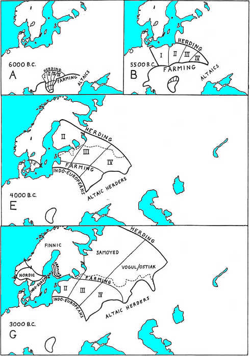
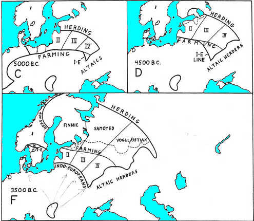
Fig. 12. Uralic expansion. The spread of Uralics is given at 500-year intervals. Cattle
herding reaches the Hungarian Plain at 6400 BC and the expansion begins at 6200 BC. Map A shows
dialect tribes, the numbered four in the North showing 200 years' worth of expansion. In map B they
reach the Baltic, while (presumed) Indo-European farmers have
closed around and isolated their source.
The herding frontier advances in C through G, and the farming frontier moves slowly behind. Map E
shows a full separation of the (presumed) Indo-European speech
line from the still-advancing farming frontier, well within the Uralic area. Heavy lines mark
language families while lighter lines show some subdivisions and economic contrasts. The dashed line
marks the reindeer boundary. |
 |
 |
The left path of Neolithic (i.e. farming) advance in eastern
Europe runs generally northward between the Baltic coast and this persistent ethnic dividing line
paralleling that coast, some 200 km inland. Farming practices transfer to Uralic natives at the
Latvian border and continue along this path to the north and north-east. Farming then curves
eastward around the head of the Gulf of Finland and finally moves into Finland itself, crossing the
modern border at 2500 BC. A short distance west of here the advance would be stopped, at about 2300
BC, when it meets a similar advance of local Neolithic (i.e. farming)
coming from the opposite direction — out of Sweden. (See Fig. 10 for the dashed line
paralleling the Baltic coast, and
Fig. 12 for the (presumed) Indo-European stopping line.)
62
Finland should not show any ethnic break at this meeting line between eastern and western
influences. On both sides it was native Finnic peoples who were adopting the full Neolithic
(i.e. farming)
practices on their own territory. There should, however, be some kind of a technological contrast
here. The two paths that met in southern Finland carried technologies that last parted company in
6500 BC in the Balkans. Over 4000 years of separate development, even on the conservative frontier
zone all the way, should have led to recognizable differences in art and style.
Further Neolithic (i.e. farming) advance to the north would
end roughly along the line of the 120-day growing season. That would include about one-third of
modern Finland. The rest of the country would stay in the hands of reindeer pastoralists for a long
time.
The remainder of the Neolithic (i.e. farming) advance in
eastern Europe, its right path, would come out of eastern Romania and run generally to the
north-east into most of Russia. This is bounded on the west by the Baltic path of Neolithic
(i.e. farming) immigration, and on the east by the Eurasian grasslands where cattle were
just being adopted by the resident Altaic sheep herders. This is a broad front, almost 500 km wide
near its beginning and increasing to over 800 km at its widest part.
The post-Romanian part of this path consists of the western Ukraine (the forested part), and then
passes over the Pripet marshes to encompass Belorussia. These marshes probably did not slow the
Neolithic (i.e. farming) advance, but were enough of a
linguistic barrier to later form part of the dividing line between Slavic to the south and Baltic to
the north.
|
The advance of farming in the G. Krantz scheme neatly correlates with the spread of the eastern part
of the Corded Ware (3200-2300 BC): |
63
The farming front at first should have advanced directly northward through Romania and fanned out
equally to the northwest and north-east within the Ukraine. After that it automatically turned more
to the north-east as its western part advanced more rapidly, and it was pressed in by the even
faster advance of farmers along the Baltic path. The line of technology transfer was then reached
along the northeastern boundary of modern Belorussia. (See
Figs. 10 and 12.)
The continuing Neolithic (i.e. farming) advance was then of
technology only, and passed through the Uralic pastoralists who were native to the area. This should
be archeologically testable where early farming passes through the area, and it should be marked by
a style line where ethnic identity changed from intruders to residents. From here on, the Uralic
substratum is presumed to be divided into two paths of about equal width. Closer to the Baltic is
the central Uralic group, here equated with the ancestral Samoyeds (i.e.
Nenetses). Adjacent to the Pontic Steppes is the right branch of the Uralics, presumed to
be the original Vogul/Ostiaks (Ugric speakers) (The name Ostiak is a
Russified form of
Türkic Asty, where as = tribe, -ty = possessive affix, i.e. genetic “tribes”, not to be
confused with the
Türkic dynastic tribe of Ases, with the same etrymology). Both of these pastoral
groups would have adopted Neolithic farming techniques and passed them on even deeper inland, with
no expectation of significant internal population movement. Increasingly severe winter conditions
along these paths would suggest that local population densities did not rise as much as in the
milder climates to the west. There is no indication that the internal dividing line between these
two Uralic language groups ever surfaced here in later populations.
The frontier of the full Neolithic (i.e. farming) economy
continued to move eastward and eventually pinched out between the converging lines of the 120-day
growing season on the north and the edge of deep soils on the south. These meet on the western
slopes of the Ural Mountains, and this point should have been reached about 1750 BC. Beyond the
120-day season, both north and east, there would be the reindeer-based Uralic pastoralists. To the
south, in the deep soils, would be the cattle-based Altaic (horse)
pastoralists. Reindeer and cattle zones meet at the Urals, and the dividing line between them
continues to the east into Asia.
64
 Western Europe
The Neolithic (i.e. farming) frontier advancement around the
western side of the Hungarian Plain constitutes the rest of the (presumed)
Indo-European source for Europe. This advance subdivides into many different routes, of which two
can be considered major. These were separated from each other by the Eastern Alps into northern and
southern branches. The northern branch leads to the largest area and is described first.
A direct course can be plotted from western Hungary to Denmark, then across the islands into
Sweden (4500 BC). From this path people filled in the western,
or
(positively non-) Celtic, side of the dividing line running from
Hungary to the Baltic. The rate of advance generally slows down along this route because of colder
winters and shorter days. There is one minor exception at the base of the Danish peninsula where
winters are warmer than before or later.
It has been calculated that the Aegean Boat People reached the Danish islands just ahead of the
overland farmers. If so, they would provide the means of transportation between these islands and
into Sweden. If this calculation is in error we may assume that the local Mesolithic water craft
were capable of moving some of these farmers and their livestock.
|
Averaged genetic Y-DNA composition of Swedes is I 34.6%, R1a 20.2%, R1b 18.7%. Accepting current
interpretation of the Hg's origins, Swedes inherited in approximately equal proportions the European
Paleolithic Hg I that does not have a depths meaningful for this work, the Central Asian-origin R1a
that migrated to Europe's Balkans via Anatolia in 10-8 mill. bp, accordingly it reached Scandinavia
in 8.5-6.5 mill. bp, or 1500 years before farmers (allowing double speed in respect to farmers), and
the European Kurgan R1b that was assailing Europe in waves from the east overland and from the south
via Gibraltar. Since the Kurgans are confidently ruled out because they are identified with the
Altaic Türkics, of the remaining two contenders, the R1a hunter-gatherers or ovine pastoralists are
more plausible contenders for pra-proto-IE for two main reasons: the carriers of the Hg R1a brought
over the IE vernaculars to the Indian subcontinent and Iranian Plateau ca. 1600 BC (3600 ybp), and
the deep commonalities between the Altaic Türkic and IE substrate that prompted classification of
Türkic as a member of the putative Nostratic macrofamily that also includes IE. The second
contender, the Hg I has a logistical argument in its favor: the I-speaking mesh was the Europe's
native and extremely widespread, it could not have been just wiped out, its islands had to survive
under all circumstances because any unfavorable events in one area could not affect all other areas.
A syncretic combination of the I and R1a vernaculars would be a most plausible hypothesis, it would
explain the loss of R1 agglutination and conversion to flexion, and provide a timeframe for IE
syncretization as a lingua franca of the Corded Ware people.
In comparison with the Swedes, the I-speaking mesh of Scandinavia in Norway with Hg I 23.3% was influenced more by the R1a 27.8%, and
about twice as much by the R1b 39.1% Kurgans. Correspondingly, their language should contain a
larger proportion of the Kurgan Türkic traces and a syncretic combination of the I and R1a
vernaculars heavier loaded with the R1a modifications at the expense of the European Paleolithic
I-language. The traces of the Aegean Shepherds in Scandinavia (Hg E) are barely noticeable (< 2%). |
This northern European path can be followed directly to the coast of eastern Sweden to where it
meets the 120-day growing season line at 3050 BC. A branch of this path would turn off to the
north-east and cross the lower end of the Gulf of Bothnia to reach Finland. I am assuming that
shipping would continue to be available throughout Sweden, even in the absence of the Sea Shepherds,
because of the area's extensive network of waterways and offshore islands. There should have been no
delay gaining transportation to the Aaland Islands and on to southwestern Finland. By counting only
land distances in this last 200-km unit the Neolithic (i.e. farming)
people and their economy should have been able to enter Finland over a long stretch of its southern
and western coasts. Shipping contact between this coastal strip and Sweden would have been
maintained thereafter. Swedish speech along this strip thus may date back to 3050 BC.
65
The rate of Neolithic (i.e. farming) advance slows
dramatically as Finland is entered, and its transfer to native Finnic speakers would be automatic
just inland from the coastal strip. In this new manner the economy alone would progress across
Finland at the rate of 550 years (the maximum) for the next 200 km. With just a small additional
advance, the Neolithic (i.e. farming) way of life should meet
its counterpart entering Finland from the south-east at 2300 BC. Not surprisingly, the archeological
contrast between these two sides of the country has long been noted, while the only linguistic
contrast is the one far to the south-west where Swedes and Finns meet (Kivikoski 1967).
The Neolithic (i.e. farming) advance can be followed up the
interior of Norway with interesting results. At the latitude of Oslo the 120-day line is met, at
3500 BC, and farming necessarily stops. Cattle herding and other traits would then transfer to the
native Mesolithic Scandinavians of the interior. This pastoralism then should have advanced through
and over other Mesolithic hunters at the rate of 75 years, plus penalties, per 200 km. After an
advance of about 270 km they would meet the southward moving Uralic (Lappish) reindeer herders in
3130 BC. This encounter is calculated to have occurred on Lake Femund, which in recent years just
happens to mark the southernmost extent of the Lapps. The remainder of the meeting line between
Lapps and Scandinavian herdsmen, and the full boundary of the latter may be seen in
Fig. 13.
|
Fig. 13. Language map at first stabilization. Shortly after 3000 BC Europe had seven language
families with the distributions shown here. In the south-east this stability was reached as much as
4000 years earlier. Areas of developing (presumed) Indo-European
dialects are indicated, along with some linguistic barriers. Aegean languages might have survived in
other places, especially in Italy and the Ligurian area. Mesolithic languages should also have
survived in the Low Countries, and in the Po Valley. |
 |
The mountainous interior of the southern part of the Scandinavian Peninsula thus contained a
presently unknown ethnic group (Hg I 25-35%). These were local
Mesolithic Caucasoids (racially), unrelated to either the (presumed) Indo-European farmers
intruding from the south nor to the Finnic-speaking Lapps (Hg N 60-85%) from the north. I shall call them
"Nordics".
66
Their approximate area of 145,000 sq km could have supported about 36,000 cattle herders at 0.25
per sq km. Their relatives in the rest of lower Scandinavia were early overrun and absorbed by the
Neolithic farmers (Y-DNA Hg I-farmers vs. Y-DNA Hg I-pastoralists).
This part of lower Scandinavia amounted to some 186,000 sq km. With a 2% incorporation of hunters
into the farmer's population in this area, this amounts to 4000 people. Native Scandinavians thus
totaled about 40,000 people, as compared with 186,000 (presumed) Indo-European farmers (assuming 1.0 per sq km initially). When they later all
mixed, these Nordics (Hg I) would constitute 17.6% of the total
Scandinavian population, not counting the Lapps (Hg N <5%). This
is by far the largest increment of native incorporation into the (presumed)
Indo-European speaking population for any major area (Patently false). This could go a long way toward explaining the
30% non-Indo-European vocabulary that Lockwood (1969) says is found in basic Germanic.
For all practical purposes the narrow base of the Danish peninsula may be taken as the division
between the Germanic of the northlands and the Celtic speech of the continent. That Germanic
initially differentiated in just such a compact area is linguistically indicated by the uniformity
of its sound shifts (Lehman 1970:2).
|
With a view that G. Krantz ascribes to Celts the 4500-3500 BC events that took place a millennium
before their migration to the European continent, and the reconstruction of the Germanic advance
from Scandinavia, it is apparent that Germanic formed at a confluence of the Y-DNA I-language with
the R1a (from Balkans) and R1b (Pit Grave Kurgan) languages. The middle of the 3rd mill. BC was a
period of mobility and changes, and is a likely time when the R1b Pit Grave Kurganians from the east
and R1b Megalith Kurganians (Celtics) from the southwest reached the Hg. I people in Scandinavia,
initiating Germanic as a lingua franca of three key linguistic groups in Scandinavia. The same time
was a consolidation period for the western chunk of the R1a Corded Ware and Celtic R1b, which was
cut off from its eastern part by a wide swash of the R1b Pit Grave Kurgan intrusion. Thus, both the
Germanic of the northlands and the Celtics of the continent carry the R1b-marked people,
Celtics on the continent, and Pit Grave Kurgans in Scandinavia. |
(Presumed) Indo-European farmers moving more nearly westward
may now be followed along the path leading to the British Isles. Their progress would be more rapid
than it was to the north — 250 years for each 200 km for most of the way. They should reach the
Straits of Dover at 4500 BC, and cross into England with the aid of the Aegean Boat People who got
there 600 years earlier. At 3700 BC they again make use of these Sea Shepherds to get into Ireland.
At 3200 BC their frontier reaches land's end at the southwestern corner of Ireland.
|
England demonstrates very moderate contribution of the the European Paleolithic Hg I (6.4%) and
Balkan R1a (8.2%). The rest is marked by Hg R1b alleles, apparently a mix of the Celtic Megalith
Kurgan R1b and Pit Grave Kurgan R1b. Accordingly, English demonstrates a heavy dosage of Celtic and
Türkic lexical and morphological contribution. The Türkic contribution carries traits of substrate,
pointing to the Sarmat and Anglo-Saxon contribution of the Kurganians [
English-Turkic
Lexicon]. |
Farming progress necessarily came to a halt after only a minor penetration of Scotland. The Moor
land is good pasturage, especially for sheep, but most of it cannot be farmed even today. Most
likely the Sea Shepherds settled this area and have biologically survived to this day. Their
original language is now lost, although Pictish is probably its last survival, which died out by
1000 AD ()
Pictish is Celtic and Scottish, it appeared when Celts reached Britain at the end of the 3rd mill.
BC, bringing their pastoral economy and Megalithic Kurgan traditions, rigid clan structure, and
trademark conical hats of the Türkic people. It took Celts about 600 years to reach Britain. The Kurgan people filled with their burial kurgans the width of the Eurasia steppes, and brought along their kurgan-covered dolmens to the Caucasus, Britain, and
Ireland.
Kurgan in Ireland (partly restored)
Kurgan is surrounded with balbals, and has a balbal-lined tail road
The sides of the Newgrange kurgan were lined with stone veneer of large pebbles
http://www.megalithicireland.com/Newgrange.htm

Other migrations, from other times, brought Kurgan Tradition to the Central and Central-Northern Europe. The last pre-historic
migration was that of the Sarmatian tribes, those people already had known names, those of Goths (Guzes
~ tribes, Vandals (Germanic wendeln “Wanderers”), and Vandal components Burgunds, Turings, and
others. In the literature, Burgunds were identified with Bulgars. The westernmost steppe peninsula
of the Pannonia throughout the millennia was a depository of uncounted migrations, with the latest
Kurgan wave associated with the Magyar-Kubar migration in the 10th c. AD.
|
67
Some form of sea navigation was most likely a local Mesolithic development in western Scotland, a
tradition which later merged with its Aegean counterpart. Such a cluster of habitable islands just
offshore should have stimulated the natives to devise shipping wherever they occur. Just as with the
Danish island cluster, local boats might have been able to transport the farmers even if the Aegean
Boat People had not been there — but we may never know for sure.
The (presumed) Indo-European progress across Germany and France
would be unremarkable, though the Low Countries may have been settled only sparsely at this time. It
should have gone roughly according to the schedule given here. The spread to the south through
France would halt along an east-west line about even with the southern border of Switzerland. This
line is where they would meet the southern branch of the western (presumed)
Indo-European farmers — those who passed to the south of the Alps. This meeting first occurs just to
the south-west of Geneva at 4800 BC, and extends due west to the Atlantic where it finally closes up
at 4350 BC.
The area allocated here to the
(positively non-) proto-Celtic speech community is very large, especially in its
breadth from central Poland all the way to Ireland. Throughout most of this area there were no
dividing lines at natural obstacles that might have created separations. The only constrictions are
those which separate Ireland from Great Britain, and it from the continent. The presence of
considerable coastal navigation, where the Boat People presumably merged with the local farmers,
would have reduced the impact of these constrictions. There were few major enclaves within the area
to set one part off in contrast to another, as with Scandinavia. The only obvious enclave was that
of the Sea Shepherds in Scotland. The region in and around the Low Countries, with its unusual place
names, remains an enigma.
I see no good reason why this entire
(positively non-) Celtic area should not have maintained a high degree of
linguistic unity for several millennia. Given the geographical circumstances this should have been no
problem. Still, it is contrary to the usual view to say that Britain and Ireland have been of Celtic
speech since the earliest Neolithic (i.e. farming). Historical
evidence of certain Celtic movements into Britain does not mean that the original inhabitants were
not also Celtic. The archeological record was formerly interpreted as showing repeated mass
immigrations into Britain, but these are now discounted by many authorities.
68
If evidence could be produced for a population replacement, or even a conquest by a higher
civilization prior to the Roman Empire, then we would have to allow for at least the possibility of
a
(positively non-) pre-Celtic Indo-European speech in Britain. It
might even turn out that the Aegean sheep herders had managed a significant and lasting area of
occupation elsewhere than in Scotland. But on present evidence neither of these seems likely.
| The whole discourse on Celtics and associated people is unfortunately off kilter (in Türkic
kiltermä). The very large area allocated to the proto-Celtic speech community belongs to
other people, possibly to I + R1a compact in the north-central Europe, and other mixes in the
western Europe. Whether the area was a continued mesh or a collection of diverse languages is a
matter of speculations, but the diversity of haplogroups rather points to co-existence of diverse
populations and diverse languages, and interspersed economies. For the spread of the Celtic people
in the 3rd mill. BC there is no need for the Boat People who presumably merged with the local
farmers, the Celts were self-sufficient in crossing Gibraltar, navigating Atlantic from Gibraltar to
Ireland, and spreading along the Western European rivers and rivulets. The 5th mill. BC farmers
probably needed ferrying help, but with the expansion speed of 200 km in 5 generations, they had
plenty of time to establish marital and symbiotic relations with their neighbors and maritime
tribes. Compared with Oceania peoples traversing from Africa to New Zealand by 30th mill. BC, the
European problems were miniscule. The suggestion on IE language in Britain prior to the Celtic
arrival is quite dubious, at least the present genetical composition of the Britain does not leave
any room for that. The virtual absence of E1b1b Y-DNA in Britain excludes a significant and lasting
presence of the the Aegean sheep herders. |
The southern branch of the western flow of (presumed)
Indo-European farmers passed from Yugoslavia into Italy with little delay.
They would be forced to by-pass the deep soils and marshes of the Po River valley before progressing
down the length of Italy and into Sicily. The sea crossing through Elba to Corsica and Sardinia was
probably accomplished at a slightly later date.
The other route of advance of this southern branch continued along the Mediterranean coast and
spread over southern France with no appreciable delay. These farmers expanded northward and would
meet the
(positively non-) proto-Celtics at the latitude of southern Switzerland. The term Ligurian was applied in
early historic times to the language community that stretched across northern Italy and southern
France. Its continuity would be natural at the time of first settlement by Neolithic farmers. A
pronounced constriction because of the mountains on the present French-Italian border should have
led to an early differentiation into eastern and western parts. Curiously, there is little
historical evidence that this happened, and the same term was used for both areas into Roman times.
The division between Ligurian and
(positively non-) Celtic stemmed from their split at the eastern Alps in Austria.
This separation was 1200 years old when they first encountered one another again in France.
69, 70
This is twice as long as the proposed initial separation between
(positively non-) Celtic and Baltic, and
it should have created a significant linguistic barrier. By the time the two sides reached the
Atlantic their separation was 1650 years in the past. The division was known in early historic times
and it survived the Latinization of Gaul. It was later reinforced by Germanic influences in northern
France that did not extend to the southern part. Today the distinction between French and Provencal
is approximately on this line. A sufficiently deep analysis of Provencal should show an ultimately
Italic connection long prior to Latinization.
| The reason for French-Provencal divide is quite different, and quite recent, it has to do with
the Burgund (aka Bulgars) Sarmat Wendeln (“Wanderers”, Vandals, Weneds, Veneti) move into Provence after the
fall of the Hunnic state, and establishing there their domain, prompting the Roman villagers and
officials to flee. The Sarmatian language dominated there from 443 to 1033, supplanted at times by
Germanic. Before and after 1033 masses of Provence Burgunds settled in other areas in the French
kingdoms, and contributed their lexicon and morphology to the French. |
To the south-west the (presumed) Indo-European farmers crossed
the eastern end of the Pyrenees and would have progressed about 200 km into the northeastern corner
of Iberia. Here they met the Afro-Asian farmers who had spread over northern Africa and moved up
through the rest of Iberia. These Iberians had essentially the same Neolithic
(i.e. farming) economy, although probably without domestic cattle at that time.
Toward the western end of the Pyrenees it was the Afro- Asians who reached the mountains earliest.
They crossed over to meet the (presumed) Indo-Europeans on the
French side at 4550 BC. At this end the transgression was much less, only about 50 km to the north
and 100 km inland.
At this point the initial distribution of (presumed)
Indo-European speech throughout Europe is complete. A discussion of this long- lasting, stable
condition must await a description of the geographical spread of the Uralic language family.
 Uralic Spread
The Uralic language family is unrelated to Indo-European, and makes up a minor part of the European
linguistic picture of today. It is of interest in this study partly because of its
present distribution, but also because it included much more of Europe in the past. In addition, a
detailed study of the Uralic subdivisions further illustrates some of the geographic principles that
are presented here.
71
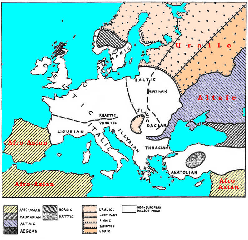
Uralic languages today are spoken across much of northern Europe and Asia, and in Hungary. Within
the USSR the Uralic and Altaic national minorities are now distributed with the former mostly in
the forest zone and the latter in the steppes. (See the eastern part of Fig. 1.) According to
most authorities the original Uralic homeland was in the Ural Mountain area, hence the name. From
this central location these people supposedly spread out in all directions to reach their present
distribution, and entered Hungary in 896 A.D.
I find all of this highly improbable for various reasons.
A geographically central location is no evidence that this is the original site of a language group.
The reason for its spread must be demonstrated — it cannot be assumed to have expanded
automatically, and equally, in all directions. The penetration of central Europe in the 9th century
by a northern Asian tribe is possible. But a population replacement, or even a language change, by
such a tribe within a well-populated agricultural region like Hungary at that time is clearly
impossible. Any such claim should be accompanied by an explanation of the mechanism whereby this
change might have been accomplished.
Given these objections the actual Uralic-speaking distributions would allow only one alternative
explanation — that the family originated in Hungary and spread out in the opposite direction. This
poses no serious problem if the time for this origin and dispersion is put at the earliest Neolithic
(i.e. farming). If this is true it means that Hungarian (Magyar) is actually the oldest
in-place language in all of Europe. To test this idea it must be shown here that the present Uralic
distributions can follow automatically from a Hungarian source, and this must be done through the
consistent application of logical rules of population movements. It must also be shown that the
subdivisions of Uralic are distributed in reasonable conformity with these rules.
72
The following is a detailed description of events that result automatically in the correct
distribution of this family. In a later chapter some additional movements are described that lead to
the modern distributions of each of its subdivisions. I can find no other approach that even
remotely fits both the known facts and simple consistency.
The Neolithic (i.e. farming) frontier first reached the
Hungarian Plain at 6400 BC, as noted earlier, according to the schedule used here. The deep soil in
this area precluded farming in all but a few choice locations. At least 60,000 sq km would remain in
the hands of Mesolithic hunters. With a density of 0.1 per sq km, there should have been about 6000
people here, expectably divided into 12 tribes of 500 each. The most parsimonious arrangement of
this number of tribes would be a row of four across the northern border, four more just below these,
then a row of three, and finally one at the southern tip (Fig. 12A). The actual number and
arrangement might well have differed from this, but the row of four dialect tribes across the
northern edge is the only item of significance here. Just as with other hunters, these dialects
should have been mutually intelligible, but with clear distinctions from each other.
From their new neighbors to the south these hunters would adopt cattle herding and many other
Neolithic (i.e. farming) traits, but little or no farming.
Within 200 years (almost seven generations) this new economy should have been integrated and spread
throughout the area. This is the same amount of time it would take to advance a herding frontier
through the plain if it started immediately upon contact with the farmers. This is also the same
time delay that was allowed for the adoption and spread of sheep herding among the Boat People
throughout the Aegean Sea.
It is assumed here that all the natives of the Hungarian Plain would have seen themselves as
something of a related unit in contrast to the inhabitants of the surrounding forested hill country.
The innovation of cattle-based pastoralism ought to have spread freely and easily among these tribes
with little transgression onto each other's territories. The eventual spread of this economy out of
the plain would begin mainly with an expansion of the edge tribes overrunning their immediate
hunting-gathering neighbors.
73
When this expansion gets underway at 6200 BC the farmers will have advanced one-third of the way
around each side of the plain. Those cattle herders moving out to the east and west from the central
section would soon be overrun by the more numerous farmers with their own cattle. Only those herders
who spread out from the row of four tribal areas across the northern edge have unimpeded and
unlimited space to expand into. These people would spread out and away from the oncoming farming
frontier, and at about twice the rate of speed of these farmers. Eventually the farmers closed in
around the northern side of the Hungarian Plain and isolated the original body of cattle herders,
but many of their descendants would already have moved out and were able to continue their expansion
into new areas. We now have two Neolithic (i.e. farming)
frontiers in eastern Europe — fast-moving pastoralists overrunning hunters, followed by slower
moving farmers who are gradually incorporating the pastoralists from behind. (See
Fig. 12 for
a sequence of seven maps showing this action.)
Of the four original hunting tribal areas on the northern fringe, the ultimate disposition of three
of these is the major theme of what follows. As cattle herding developed, and population increased
by maybe 2 1/2 times, these four tribes should have begun to subdivide into smaller areas with
comparable populations. As each subdivides into two or three social groups within its original
hunting territory they would also be sending surplus population outward into new areas. The
linguistic differences that separated the original four hunting tribes would be perpetuated in the
rapid spread of people from each of them. Linguistically speaking, four distinct dialects from the
Hungarian Plain would radiate outward with these expanding populations. One can assume that each of
these four groups started out with equal numbers and reproductive potential, and came to occupy
comparable tracts of land. These are referred to as groups I through IV, which may be followed along
paths of the same numbers.
74
A new irregularity must be introduced at this point
concerning the directions of spread of the four groups. At first
glance it would seem they should spread over a full range from
north-west through north-east — at least 50° both west and east of due north. In fact they would
spread to the west by no more than
30° from north. This consideration was based initially on
examination of subsequent linguistic distributions. If Group I
on the left had spread as much as 45 west of north, then its
people would have gained access to Denmark. From there they
should have had little difficulty crossing into Sweden (using
local Mesolithic boats) and spreading over the main part of
Scandinavia. These should then be the ancestors of the Lapps who
switched from cattle to reindeer herding along the way.
The first problem with this scenario is that Lapps have a
Finnic-related language, clearly a part of Group II that can be
traced up the east side of the Baltic. A Group I origin for the
Lapps would have made their language one of the major branches of
Uralic, instead of just a subdivision of Finnic. The second
problem relates to the 30% of non-Indo-European vocabulary that
is found in the Germanic languages. The only obvious source of
this vocabulary is the native population of Scandinavia. If
these had been herders out of the Hungarian Plain, then the
outside component in Germanic should have been of a Uralic type.
Evidently it is not, as this is the first possibility that would
have been looked at.
The Eurocentric paradigm of the European history created gaps as wide as the other nationalistic
or parochial (take Vatican) histories. In this case, the labels “IE”, “Germanic”, “Christian”, “Roman/Latin”, “Greek”
etc. help to obscure and obfuscate the syncretic nature of modern languages, centering on scholarly
“*IE *reconstructions” instead of apparent common elements outside of the box. The Türkic, under whatever guise it
comes, from Kurgan to Wendeln, happened to fall into a gap in perceptions created by circular
logics. The cul-de-sac where the Germanic linguistics is parked for a good century is stashed with a
supply of substrates ranging from 30% (popular number) to 75% (Vennemann, 2000 p.233). The
exit direction is obvious, Germanic folklore is not shy to talk of Ases, Atilla/Etzel, “out of Asia”
and such, but so far that did not permeate into the IE-stic philological hamlet. Not for the lack of
the evidence or absence of voices, as exemplified by the present work.
If the outside component in
Germanic should have been of Uralic type, and evidently it is not, then what? A campsite in the cozy
cul-de-sac? |
In this reconstruction we are compelled to block the
westward spread of these cattle herders at about 30° west of north, and thus have them fail to reach
Denmark. The only apparent reason for this would be the density of the Mesolithic hunter population
in the western part of Europe where winter survival was easier. Native hunters would take a toll of
domestic animals and of the herders themselves. At some level these hunters would be so numerous as
to delay, and perhaps even stop, the progress of these pastoralists. Rather than try to develop a
new delaying factor for this one case I simply limited
the westward spread of cattle herders to the radius at 30° west of north
(contradicting the set criteria of Why? to account for reality).
| A simpler and universal Why? solution is found nearly everywhere in the pages of history.
Uralics, for example, were described as “no go” people, and that reputation was strong enough to
stop their greedy neighbors from plundering and subjugating them. Their reputation was that they
kill everybody who penetrated into their territory. This daunting reputation safeguarded them for
centuries and possibly for millennia. The taboo clause can be pulled out of hat every time the
paradigm buckles under a weight of reality, and in reality it does not take much to scare the wits
out of people: Attila did it, Chingizkhan did it, and Americans did it with Japan. A little scare is
way more productive than a great fight. |
75, 76, 77
Each of these four dialects then would fan out of Hungary
over an arc of about 20° by Mercator projection. Group I centers
on 20° west of north, Group II starts out due north, Group III
centers on 20° east of north, and Group IV has a heading of 40°.
Group I would fan out over most of western Poland, reaching the
Baltic Sea in less than 500 years. Within the next 700 years
they would be ignominiously overrun by farmers and terminated
without linguistic issue.
Group II moved due north at first, then automatically curved
to the east. This curve results in part from the differential
advance rate between themselves and the slower Group III on their
right. It may also follow from the pressure of their own members
edging to the east to avoid dead-ending along the Baltic coast.
Group II continues northeastward and around the Gulf of Finland,
presumably crossing at the narrow part (20 km) just west of
Leningrad. They should also pass around to the east of Lake
Ladoga. This arm would have been nearly pinched off at this lake
by Group III. Some of them should have advanced on up the west
side of Lake Onega, but Group III would take its east side.
| Genetics provides an irrefutable argument against the suggested Uralic paradigm. The paradigm
must account for the predominance of the Y-DNA Hg N (50.7%) in the Uralic people. The Hg N is
overtly Mongoloid and centered in the Far East, where it evolved ca 7000 ybp. Its migration is
traceable and datable by its alleles, and is known in a rough outline as far as the available
testing allows. That data can't place people marked by the Y-DNA Hg N anywhere in Central Europe,
Eurasia, or the world before 5000 BC (7000 ybp), while the suggested paradigm places it in the
Pannonia. Turning away from the Eurocentric genre would allow to apply the proposed scheme of
expansion to the spread of the Hg N, and compare the modeled spread with the data of the genetical
analyses. The 5000 BC date falls on the waning period of the Far Eastern Mesolithic, and the data
would allow to calibrate the spread of the Mesolithic hunter-gatherers. In the Eurocentric studies,
the direction of migrations is bent to suit the vaulting concept, and the suggested Uralic paradigm
parallels that of the M. Gimbutas, so soundly rejected by the author. |
Somewhere along this course it may be assumed that there was
a transfer from cattle to reindeer herding. I have put this at
the recent boundary between mixed forest and the fully coniferous
forest. (This boundary is given in many atlases with minor
variations, so I used the one from Goode's World Atlas. 15th
edition, simply because it had the fewest irregularities.) Along
the path of Group II this event would center on the modern border
of Estonia and Russia (Fig. 12D). After the change to this new
major domesticate it is assumed that their population density
would go down somewhat, and the area occupied by a 500-person
tribe would correspondingly increase. It is also assumed that
the density of local hunters would also be declining, so as to
permit this. From here on, their rate of advance has been
somewhat arbitrarily increased to a basic 60 years per 200 km —
the time reduced from the 75 years that was used for them as
cattle herders. The same rules continue to be applied for the delay factors from reduced winter
temperature and daylight. Each increment of these two factors adds 20 years (again one-third of the
basic rate) to the time required to advance the frontier by 200 km. The maximum application of these
penalties is still held to the same four increments for each factor. The slowest rate of progress
for this set of conditions now becomes 220 years per 200 km, vs the 275 years for the cattle-based
economy.
78
With this new rate of advance, the herders of Group II, the presumed Finnic branch of Uralics, would
have spread over all of modern Karelia and Finland. Their progress would continue around the head of
the Gulf of Bothnia and then down the Scandinavian Peninsula. On the shore of this gulf, about 180
km north of Stockholm, they would encounter the (presumed)
Indo-European farmers who had been advancing to the north. Both groups should reach this meeting
point sometime between 3200 and 3100 BC. The exact timing is not very critical here because this is
also the stopping line for farmers — the 120-day growing season. The Neolithic farmers with their
boats, cattle, and greater numbers should have extended their occupation some distance beyond this
meeting, but only along a thin strip of the Baltic coast.
Aside from the northern-most Uralics beyond the Arctic circle, the available historical sources
do not provide information on their economy. From the indirect indications (trade limited to furs,
tributes paid exclusively in furs, the spectrum of goods received in exchange, references to
stationary villages) can be deduced that up to 1000 AD, Uralics remained foot hunter-gatherers, tied
to their territories and hunting ranges. The premise of Uralic pastoralism, fundamental for the
author's Uralic paradigm, conflicts with the historical records. The northern forest area occupied
by Uralics also does not lend itself to pastoralism as a prime sustenance; that was the prime reason
for the Altaic pastoralists to stop at the forest-steppe border. Stopping at the border economically
did not prevent Altaics from trade, collection of tribute, and establishing marital relations.
The
example of the horse-pastoral Magyars does not conflict with the sources, Magyars were incorporated
into the Altaic pastoral societies, left their forest ranges, and adopted the steppe horse-pastoral
economy of their allies, who likely were their marital partners, and definitely were a dominating
strata. The three tribes of Kubars were Türkic Bulgars in permanent revolt against infringement on
their Tengrian religion, Magyars were headed by Arbat son of Djilka of the Hunnic dynastic Dulo
clan, and Arbat led them to the Bulgar-ruled Pannonia, probably to find shelter with some of his
ruling relatives. The bulk of the refugees however were the Magyar tribes, and that is a typical
ruler-subject hierarchy. These social and possibly marital connections do not make Magyars Türkic,
but explain their non-Uralic economical and military traits. The symbiotic and ethnically-open
traditions of the Türkic societies make the Magyar case ordinary and rather typical, repeated in the
Rus, in Scandinavia, and in the Danube Bulgaria, among many others. |
In the interior of Scandinavia the southward progression of Group II Uralics would be stopped at
Lake Femund at about 3130
BC. Here they should have met the local Nordic pastoralists who had adopted cattle herding from
the incoming (presumed) Indo-European farmers. Shortly
thereafter, the meeting line would automatically extend almost due west from here to the Norwegian
coast. The southern farmers can also be expected to have extended their control of the Atlantic
coastal strip substantially to the north.
The area inhabited by Group II Uralics was also being overrun from behind by the advancing
(presumed) Indo-European farmers who had surrounded and then
passed beyond the source area. The progress of these farmers would have gradually slowed and finally
stopped on the Lithuania-Latvia border at 4400 BC. Farming then would have automatically transferred
to these Finnic speakers who
added it to their economy and passed it on through their fellows as far north as the 120-day
growing-season line. This would eventually mark the division between Finnish and Lappish. The
distribution of Finnic languages, from Latvia through Lappland, would remain little changed until
the advent of deep-soil plowing that entered their area around 700 AD. Even then, what territory
they lost in the south was more than made up by gains in the east. This is described later. The
total area occupied by this linguistic unit included an impressive part of Europe, both then and
now, but their numbers have never been very great.
79
The progress of Group III Uralic herders was fairly simple. They expanded out of the Hungarian Plain
at 20° east of due
north, and gradually curved more to the east because of the advance-rate differential with Group IV
on their right. Eventually they progress almost due east, but this is largely a simple consequence
of their great-circle route being plotted on a Mercator projection.
Group III Uralics should have adopted reindeer herding at the same line of full coniferous forest —
about 400 km east of Leningrad. They soon reached the Arctic coast and progressed along it as far as
the Taymyr Peninsula. This automatic distribution coincides almost exactly with the modern Samoyed (i.e.
Nenetses)
speech area after some of its European part is subtracted later by other peoples. Their
identification with this branch of the Uralic family would appear to be unavoidable.
Group IV Uralics left the Hungarian Plain from its
northeastern corner — a seemingly minor fact that proves to have
great significance much later. Their progress centered on 40° to
the east of due north, and this also follows a great-circle route that eventually heads due east
into central Siberia. Their path was bounded by
Group III on their left, and by the forest edge on their
right. Here they should have been almost keeping pace with the spread of cattle keeping that was
being adopted by the previous sheep-herding Altaics in the Steppes. Deep into Russia most of them
would be expected to adopt reindeer herding upon entering the purely coniferous forest. The
automatic
distribution of peoples along this path, with appropriate later subtractions nearer their source,
coincides almost exactly with the Vogul/Ostiak branch of the Uralic family. This linguistic
identification is assumed to be the case.
80
Groups III and IV were being overrun from behind by Neolithic farmers just as Group II was. These
(presumed) Indo-European farmers were able to advance over what
is now Belorussia, then bogged down and transferred their farming to these Uralic cattle herders.
With all three Uralic groups, Finnic, Samoyed (i.e.
Nenetses), and Vogul/Ostiak, the farming technology moves
through them at the rate of 450 or more years per 200 km. While this would increase their population
it would likely be too little and too slow to cause any significant movements of people. The
linguistic boundaries should have stayed constant after this farming transfer.
| As budding Russian state was capturing and colonizing territories east of Itil/Wolga, it was
imposing a tribute, called with a Türkic term yasyk, on the captured populations. The
material payments were in kind, a set quantity of products. Peasants were imposed a grain supply
tribute, hunters a fur tribute, miners a coal tribute, etc. At that time, starting at ca. 1600, like
in the previously captured lands, the Uralics' tribute was not in cattle, nor in horses or grains,
but solely in furs. In the 19th c. the yasak tribute was replaced with monetary tribute. The
Novgorod bookkeeping documents apparently were destroyed after the Moscow duchy defeated and ravaged
the Novgorod republic in 1478 AD, but it is known that the Moscow-Novgorod war of 1397 was led for
the right to collect the fur tribute from the Novgorod-controlled territories populated by various
Fennic people. This conflicts with the premonition that Uralics switched to pastoralism or farming
anytime before 1600s AD. Actually, even with the collectivization of the Soviet economy in the 1930s
the newly created hunting collective enterprises were imposed fur taxes, since money were used only
for accounting purposes. |
Most linguistic classifications of the Uralic family first separate Samoyed (i.e.
Nenetses) from the rest, and then
subdivide these into Finnic and Ugric (Magyar plus Vogul/Ostiak). This is not in accord with the
three co-equal groups described above. However, other detailed analyses of Uralic do give the three
groups as used here. Hajdu (1976) shows that these three are almost exactly equally distinct from
one another.
The lengthy description given above is of regular and geographically predictable events. These would
have-led automatically to a distribution along the three major migration paths directly into the
areas that the three Uralic branches occupy in more recent times. This has involved no unexplained
migrations or expansions of a "historical" nature to put these people in their correct locations.
This appears to be much more than mere coincidence. Finer dating of the pertinent archeological
remains should show the direction of movements (Curiously, if the
distribution map is mirrored, it would place the origin of the same Uralic languages in the northern
Kazakhstan).
It remains to be shown why it is Vogul/Ostiak, and not one of the other two, that should be the most
closely related to the recent language of Hungary — Magyar. There is also a major shift to the east
by many Finnic speakers that must be accounted for. Both of these are neatly explained in a later
chapter as automatic consequences of a technological change a few thousand years after this initial
dispersal.
81
 Language Map
After the Neolithic (i.e. farming) economy spread to its
natural limits in all possible directions, the linguistic map of Europe achieved a long-lasting
stable condition.
For the southeastern corner this time of stability dates back as far as 6500 BC. For most of Europe
stability was reached by around 4000 BC, while in Ireland and Scandinavia a few minor ethnic
movements continued through the next millennium. Fig. 13 shows the distribution of languages
that automatically results from the processes that have been described up to this point.
From this time of settlement, all the way up 500 BC, there is no indication of any significant
factors that would have made changes in the linguistic geography of Europe. For most of the
continent this first period of stability lasted 4000 years; for some parts it was over 6000 years.
This is much longer than all the time that has passed since then. The remaining linguistic movements
and differentiations occurred mostly in just a 2000 year period from 500 BC to 1500 A.D. These
consisted of four major events that grade into one another, and which can be separately mapped only
with some arbitrariness. The only other period of relative stability is the last 500 years of European history.
On the opposite, the purported tranquility of 4000 years in the archeological records and
genetical studies tell of major upheavals, population disappearance (called bottlenecks in the
population genetics), sudden disappearance of whole archeological cultures, complete replacement
with different cultures, and the like.
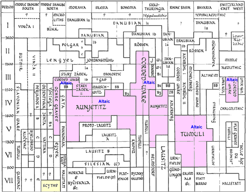
These events are reflected in the dynamics of the Corded Ware map above and archeological graphs
below:
Gordon Childe chart
Childe, V. Gordon (1925), The Dawn of European Civilization
1st edition (6th revised ed., Routledge & Kegan Paul, London, 1957)
Click on image to enlarge ==>
CLICK HERE TO REDUCE
|
Lichardus & Lichardus chart
Lichardus Jan et Marion Lichardus-Itten (1985), La protohistoire de l’Europe. Le Néolithique et
le Chalcolithique entre la mer Méditerranéee et la mer Baltique, PUF, Paris
Click on image to enlarge ==>
CLICK HERE TO REDUCE
|
|
The map of Europe during this first stabilization shows a number of very different languages that
largely surround the continuous dialect mesh of (presumed)
Indo-European intruders. In the southwestern corner Iberia is occupied by presumed speakers of the
Afro-Asian family that also stretches across northern Africa back to their source area in the Near
East. In a smaller northwestern corner is the Pictish speech of Scotland that may ultimately derive
from the Mesolithic Boat People of the Aegean. To the north we find part of the wide-spread Uralic
language family that continues through most of Finland, Estonia, Latvia, and Great Russia, as well
as their surrounded source land in the Hungarian Plain. The Altaics stretch from eastern Romania,
through the Ukraine, and on into central Asia. Caucasian occupies northeastern Anatolia and the
Caucasus Mountain area. Brief Mesolithic survivals no doubt occurred in many places, the
Scandinavian cattle herders being the most conspicuous of these, and the only one shown in Europe.
The Hattics are a major survival in Asia Minor. Others would have lasted for some time in such
places as the Po River valley and the Low Countries, but they were of no ultimate significance and
eventually disappeared. The Aegean Sea Shepherds left settlements along much of the Mediterranean
and Atlantic coast, but these too were rapidly absorbed when the full Neolithic
(i.e. farming)
economy arrived in each area from the landward side.
82, 83
The central core of Europe is occupied by (presumed)
Indo-European speakers at this time. Their boundaries with all the other languages mentioned here
are sharp and total. Only through Anatolia, and from there on into Iran and India, do they have
linguistic continuity outside of Europe. The otherwise simple picture of a dialect mesh of gradual
differentiation is broken in only a few distinct places, and none of these is fully bounded.
A major dividing line developed when the immigrant farmers were separated by the full length of the
Alps and Eastern Alps, and this line was then extended to the Atlantic coast from their meeting
point beyond that barrier. This separated
(positively non-) Celtic from the Ligurian-Italic speech areas, but their
linguistic continuity was maintained around the eastern end of the mountains. A similar separation
occurred when the farmers passed around the Hungarian Plain, met again on its northern side, and
continued this dividing line to the Baltic shore. This was the initial basis for a division between
(positively non-) Celtic on the west, and Balto-Slavic on the east. A mountain and temperature barrier in the eastern
Carpathians led to yet another separation whose repercussions become evident only later. The Pripet Marshes provide a partial barrier between Baltic and
Slavic. Germanic tends to pinch off from
(positively non-) Celtic at the constriction of southern Denmark. Reduced
communication tending to separate both Ireland and Great Britain ought to have caused some
divisions, but apparently these were not significant. Indo-Iranian is not distinguished here from
Anatolian because this separation nowhere affects the reconstruction of European language
distributions.
84
The (presumed) Indo-European dialect mesh in Europe at this time
would show some divisive tendencies, but none need be called separate languages. Those at the
prominent meeting lines maintained continuity back through their places of initial separation, no
matter how distinct the linguistic barrier at the far end might have become. Constrictions should
still have maintained continuity even if the changes were rather abrupt through the corridors. Sheer
distance, combined with minor geographical barriers, would have tended to emphasize regional
contrasts.
The map, of Europe at this time can be labeled with many (presumed)
Indo-European "languages," but it must be noted that these are probably only dialects in a complex
network, and none would necessarily be truly distinct or bounded from any other. Linguistic
innovations that appeared at any point within the mesh would still tend to spread eventually over
the entire system. In other words, this dialect mesh continued to evolve, or change over time, as a
single unit, regardless of its slowly increasing internal diversity.
These (presumed) Indo-European dialects would not separate into
independently evolving lines until something happened to create separate groups that were fully
bounded from each other.


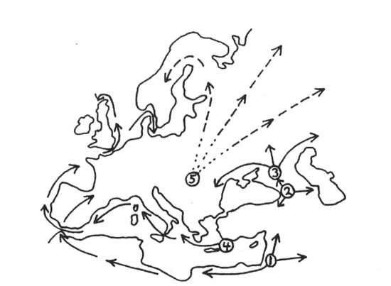
 Neolithic Origins
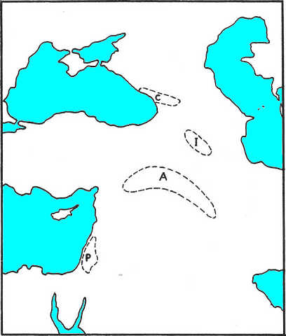
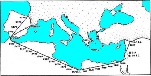
 Afro-Asian Spread
 Caucasian Farmers
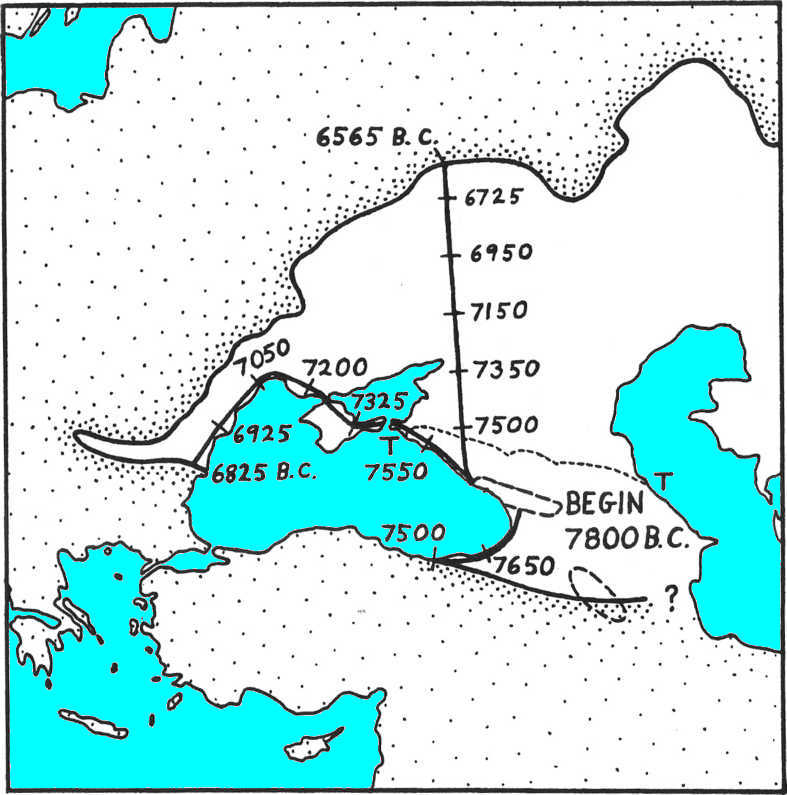
 Altaic Shepherds
 Indo-Europeans
in Asia
Indo-Europeans
in Asia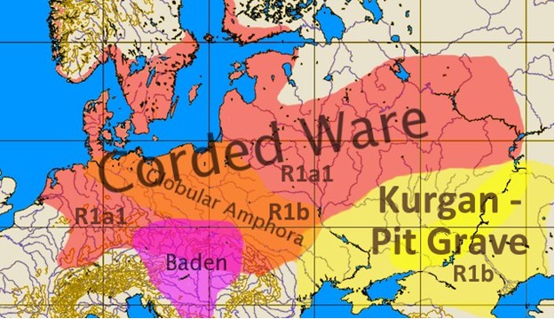
 Sea Shepherds
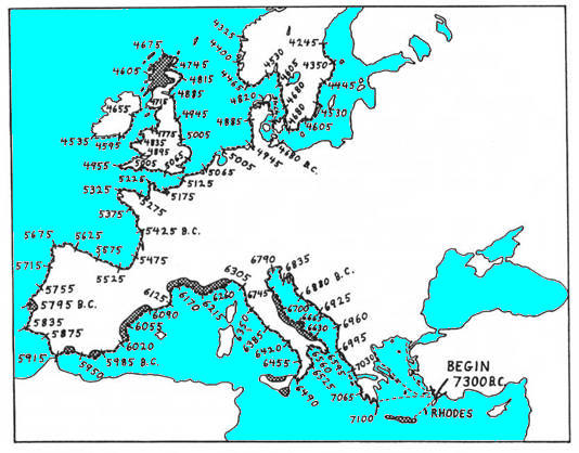
 A splinter of
R1a-marked Corded Ware slow-moving farmers continues their escape across Türkic Kurgan Middle Asia
to the Indian subcontinent and Iranian Plateau, arriving there at ca. 1600 BC and forming there the
Indo-Iranian linguistic branch of the IE family.
A splinter of
R1a-marked Corded Ware slow-moving farmers continues their escape across Türkic Kurgan Middle Asia
to the Indian subcontinent and Iranian Plateau, arriving there at ca. 1600 BC and forming there the
Indo-Iranian linguistic branch of the IE family.