
HUN COUNTRY AT THE CASPIAN GATE
Caspian Dagestan during the epoch of the Great Movement of Peoples
Dagestan Publishing, Makhachkala 1995, ISВN 5-297-01099-3
© Гмыря Л.Б. Gmyrya L.B.1995
Chapters 1-2
ANCIENT AUTHORS ABOUT CASPIAN DAGESTAN, GEOGRAPHY
|
|
L.Gmyrya HUN COUNTRY AT THE CASPIAN GATE Caspian Dagestan during the epoch of the Great Movement of Peoples Dagestan Publishing, Makhachkala 1995, ISВN 5-297-01099-3 © Гмыря Л.Б. Gmyrya L.B.1995 Chapters 1-2 ANCIENT AUTHORS ABOUT CASPIAN DAGESTAN, GEOGRAPHY |
|
Posting Foreword |
||||||||||||||||||||||||||||||||||||||||||||||||||||||||||||||||||||||||||||||||||||||||||||||||||||||||||||||||||
|
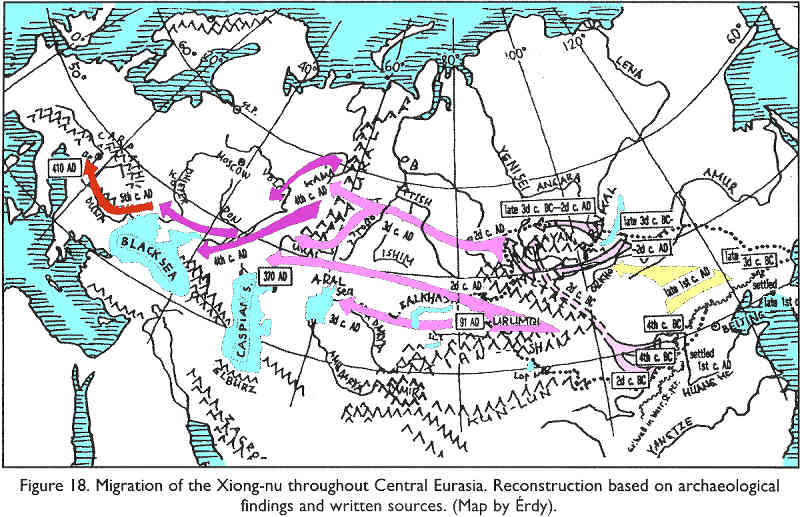
Posting introduction see the contents page. The Caspian Huns fit neatly into the partial maps of Hunnic migrations composed by M.Erdy, who archeologically traced Hunnic migrations from east to the Central Europe, without addressing the Caspian Huns and South-Central Huns. The maps of M. Erdy do not show the artifacts of the Hunnic branch in Dagestan and its vicinity, but that does not mean that they were not found. 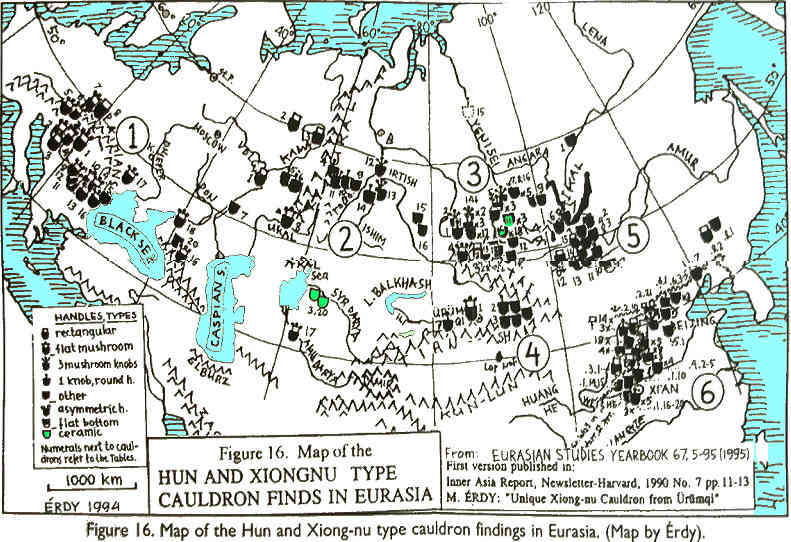
Poor print quality hurts the accuracy of this posting, but fortunately the contents are not impacted. Page numbers of the original are shown at the beginning of the page in blue. Page breaks in continuous text are indicated by //. Posting notes and explanations, added to the text of the author and not noted specially, are shown in (blue italics) in parentheses and in blue boxes, or highlighted by blue headers. |
||||||||||||||||||||||||||||||||||||||||||||||||||||||||||||||||||||||||||||||||||||||||||||||||||||||||||||||||||
|
INTRODUCTION |
||||||||||||||||||||||||||||||||||||||||||||||||||||||||||||||||||||||||||||||||||||||||||||||||||||||||||||||||||
|
From most ancient times, from the end of the 3rd - beginnings of the 2nd millenniums BC, masses of nomadic tribes were coming to the Caspian littoral Dagestan (Caspian Dagestan). In the early Middle Ages this region was a permanent homeland for numerous nomadic and semi-nomadic tribes of the Türkic-speaking world: Maskuts (Gr. Massagets), Alans, Hailandurks (Haidaks ~ Kayi + dag < Mountain Kayi), Huns, Basils, Ugors, Saragurs, Onogurs (Hunogurs), Savirs, Khazars, Türks, etc. The most important political and military force in the Eastern N.Caucasus from the end of the 4th to the beginning of the 8th centuries where the tribes of the Hunnic circle, and the Caspian Dagestan is called in the ancient writings a land, a country or an empire of the Huns. It is possible that the ethnonym “Huns” is a collective name for a multi-lingual population of the Caspian Dagestan during the Hunnic epoch, including the local agricultural population that lived since ancient times on the lands where along the western coast of the Caspian Sea run important trading roads. Noting the fateful consequences of the global movement of the nomadic tribes in the early Middle Ages for the history of the South-East Europe peoples, including the Northern Caucasus, many researchers do not take into account the complex processes of interaction of the local sedentary-agricultural and nomadic population with the migrant nomadic tribes. The archeological research in the Caspian Dagestan revealed a large number of
fortresses, settlements and burials of the early Middle Ages time, many of them were
excavated. The excavation materials do not confirm the opinion settled in the literature
about a mass destruction of the settlements, or decline and desolation of significant
territories (see, for example, works of S.A.Pletneva). On the contrary, the cultural
layers of the 5th-7th centuries demonstrate a rise of the economic and cultural
development. This research is completely based on the tidbits in the written sources about Caspian Dagestan scattered in the historical works, geographical treatises and atlases, chronographs and annals, and also in the diplomatic documents and poetic compositions.. We attempted to recreate an objective picture of the historical development of the Caspian. Dagestan tribes during the early Middle Ages: a political history, social-economic, ethno-cultural development and ideology. This work reflects contributions to the Caspian Huns subject (M.И. Artamonov, N.V.
Pigulevskaya, I.C. Gadlo, p.G. Klyashtorny, А.P. Novoseltsev, A.P. Shihsaidov, Ya.A.
Fedorov, G.p. Fedorov, V.G. Kotovich, Yu.R. Djafarov, etc.). The work widely used
ethnographic materials collected by researchers from the territory of the historical
location of the Hunnic tribes in Dagestan, linguistic research and folklore materials
(p.Sh. Gadjieva, B.M. Alimova, A.G. Bulatova, G.A Gadjiev, A.M.Adjiev, Kh.M Halilov, N.p.
Djidalaev). |
||||||||||||||||||||||||||||||||||||||||||||||||||||||||||||||||||||||||||||||||||||||||||||||||||||||||||||||||||
|
1. ANCIENT AUTHORS ABOUT CASPIAN DAGESTAN |
||||||||||||||||||||||||||||||||||||||||||||||||||||||||||||||||||||||||||||||||||||||||||||||||||||||||||||||||||
|
(The following section is only a brief summary that abbreviates the discourse to names and essential facts. For complete contents please refer to the associated Russian text - Translators Note) About the Caspian tribes during the time of the Great Movement of Peoples left records antique and eastern authors. The works containing data about Caspian tribes are written in Latin, Greek, ancient Armenian and Georgian languages. About Caspian tribes is plenty of data in Arabic and Persian literature, in the sources in Hebrew and Turkish languages. These works are diverse: historical compositions, geographical guides, guidebooks, maps, annals, travelers notes, military reports and state employees, poetic compositions of the court poets. |
||||||||||||||||||||||||||||||||||||||||||||||||||||||||||||||||||||||||||||||||||||||||||||||||||||||||||||||||||
|
1.1. ANTIQUE AND EARLY BYZANTINE WRITERS |
||||||||||||||||||||||||||||||||||||||||||||||||||||||||||||||||||||||||||||||||||||||||||||||||||||||||||||||||||
|
The works of western Roman and early Byzantine writers, along with extensive data
about many countries and peoples, include many records about Caspian Dagestan, but all of
them mainly relate to the Hun circle tribes. The most ancient records about Caspian Huns belong to the 2nd c. AD. In the middle of the 2nd century a Classical writer Dionisius Periegetes in a poetic composition “Description of the inhabited Earth” names Huns (Unns) living at the northwestern side of the Caspian Sea. Dionisius is from Egypt during emperor Hadrian (117-138) Much of his data about location of tribes is authentic and agrees with ancient eastern data. In the second half of 2nd c. AD, famous Alexandrian astronomer and geographer Claudius Ptolemy notes Huns (Uunns), living at the time of Roman Emperor Marcus Aurelius (160-180). In the works of the Ancient and Byzantine authors, contemporaries of the Great Migration, information about Caspian Huns appear at the end of the 4th c. The earliest information about the Caspian Huns for that time is in Eusebius Hieronymus (Sophronius Eusebius Hieronymus, St. Jerome) - one of the most famous church historians. Eusebius Hieronymus was born about 348 in Stridon, a town on the border of Dalmatia and Pannonia, was educated in Rome, and extensively traveled. In 389 he retired to a monastery he founded in Bethlehem, where he wrote most of his works: historical - “Translation and continuation of Eusebius Chronicle (Chronicon of Eusebius)”, works on the translation of scripture, sermons, letters, etc. In one letters, written in 396's. Eusebius tells of an invasion in 395 of the Caspian Huns to Asia Minor and Syria. The same event he describes in another letter, written in 399. Some information on the Caspian Huns has the Eusebius contemporary Claudius Claudian (375-404). Claudius Claudian was born in Alexandria, in 394 moved to Rome. For a long time he served at the court of a prominent military and political leader Stilicho. Numerous poetical works of Claudius Claudian have survived, where he often touches on a variety of political events, a contemporary of which he happened to be. One of his poems against Rufinus, a courtier of Eatern Roman Emperor Arcadius (395-408), “On Rufinus” contains information that Caspian Huns penetrated into the eastern limits of the Byzantine. Claudius Claudian also gives an ethnographic portrait of the Huns. Another Latin poet, Rufus Festus Avienus, who lived in the second half of the
4th c., composed a poetic translation of Dionysius “Description of the World” . It
contains data on the fact that near Caspian Sea, next to Albanians, live Scythians, under
which the name apparently were meant Caspian Huns. Books against Rufinus were written in 395
- 398
(Latins knew Huns as generic Scythians, i.e. Türkic-speaking
horse pastoralists). One of the most brilliant and original secular historians of the 4th c. was Ammianus Marcellinus. Ammianus Marcellinus does not have direct evidence on the Caspian Huns, but we used information given his “History” on European Huns, echoing the descriptions of the Caspian Huns by other authors. It is mostly. ethnographic information. Ammianus Marcellinus was a Greek by origin, he was born about 333 in Antioch, died about 400 AD He came from a Greek intellectual Gentile family in Syria. From 354, he served for several years under famous Roman general Ursicinus. Under his leadership, he participated in a war with Persia (359), and the barbarians in the West, in Germany and Gaul. Ammianus Marcellinus also witnessed military campaign undertaken by the emperor Julian (361-363) against Persians in 363, that ended with a rout of the Roman army and a death of Julian (Udaltsova Z.V. 1984. pp. 124-125). In 363, Ammianus Marcellinus left military service and returned to Antioch. He traveled widely, visiting Egypt and Greece. At the turn of the 380s Ammianus Marcellinus moved to Rome, where he began compiling his work, “Acts” or “History”,consisting of 31 books. The first thirteen books did not reach us, the preserved books describe events of 353-378.
The value of Ammianus Marcellinus work is first of all that it was based on his personal
observations during his own life. They also used eyewitness accounts and documents in
state archives. For our theme of interest is the detailed description of the visible appearance of the Huns, type of their food, and dwelling architecture. We find in the Ammianus Marcellinus “History” //11// information about social structure of the Hunnic Union in the early period of the Great Migration, the level of military art and arms. Ammianus Marcellinus also provides some evidence of the Huns' occupations.
General information about arms of the European Huns provides Flavius Vetatius Renat, a Latin writer, the author of “Short essay on military art” in 4 books. The essay was written between 383 and 450. Flavius Vetatius Renat notes that the weapons and defense, adopted from Alan, Goths, and Huns, had its influence on the development of military arts in the Roman army. The authors of the 5th c. know of the Caspian Huns as little as
their predecessors. The Byzantine historian and diplomat Prisk Pannonian,
distinguished by a deep and versatile knowledge, wrote in 470s his famous work “Byzantine
history and deeds of Attila” (name to Priscus works is per Udaltsova Z.V. (Udaltsova Z.V.
1984, p. 872)), which contains a detailed account of the Byzantine 448 AD embassy to the
ruler of the European Huns Attila, preserved only in fragments. Priscus was born in the
first quarter of the 5th c. in Panione in Thrace, and putatively died after 472
(Udaltsova Z.V. 1967. pp. 19-20, 1984, p. 371). Priscus was a member of the
patrician Maximen Byzantine embassy to Attila in Pannonia. It is believed //12// that Prisk based his work on his diary. Perhaps he also used records of diplomatic correspondence, reports of the Byzantine ambassadors, and other documents from the Imperial Library (Udaltsova Z.V. 1984. pp. 372-73). Although the Prisk's detailed story about Atilla capital contains much information about the European Huns, for us it is of interest as a comparative material for certain aspects of life of the Caspian Huns. In his work Prisk describes the Hun settlements, describes palace architecture of Attila and his courtiers, in detail describes the interior of Attila and his wife Kreka (known as Kharka => Khark + ev = Kharka + house => Kharkiv) suites. For our theme is also of interest the detailed description given by Prisk of various
machines for storming fortifications in the Huns' armed forces in 440's. The storming
machines of European Huns have direct analogies among similar weapons of the Caspian
Huns-Savirs, described by Procopius of Caesarea (6th c.). Information about early history of the Huns has another Byzantine historian of the 5th c. Zosimus. He is the author of epic composition, known as “New History”.Created during the reign of the Emperor Anastasius (491 - 518) at about 498, and was published posthumously. The Zosimus “New History” covers the history of the Roman state from the reign of August //13// (27 BC) to 410 AD. Little is known about the life of Zosimus: he lived in the second half of the 5th c. in Constantinople, where he served in senior positions in financial apparatus of the Byzantine state (Udaltsova Z.V. 1984, p. 145). His “New History” contains information on the appearance of the Huns in Istria in 375, and more importantly, Zosimus stated that Huns came to Europe from Asia. It is believed that describing the events of the 4th - 5th cc. Zosimus relied on writings of the Byzantine historians Eunapius (345 - 420) and Olympiodorus (5th c.), which were preserved in fragments. In 412 Olympiodorus visited the Huns with a diplomatic mission of the Byzantine embassy, during that period they lived (I.e. their field capital was located) by the north-western coast of the Black Sea (Udaltsova Z.V. 1984. pp. 143 - 144). Information on the territory of the Caspian Huns (Scythian Huns) (Latins knew Huns as generic Scythians, i.e. Türkic-speaking horse pastoralists) a 5th c. Roman geographer Julius Honorius placed in his comments to his map “Description of the World”. In the “Description of the World” by Priscian, who lived in the second half of the 5th - the beginning of the 6th cc.., was preserved a Latin paraphrase of the “Description of the World” by Dionysius Periegetes. This work used some information about the European
Huns, given in the poem of Apollinarius
(Apollinaris) Sidonius, a Bishop of Clermont,
who lived ca. 430 - 480 AD. Have survived a collection of his poems and nine books of
letters. In one of his poems, “Panegric to Antemius Augustus, secondly a consul” Apollinarius Sidonius gives a physical description of the Huns, tells about method of
skull deformation customary among the Huns, he also has information about weaponry of the
Hun warrior, organization of military, and some evidence on the economy of the Hunnic
society. Most valuable information about tribes of the Caspian Dagestan give the works of a prominent 6th c. Byzantine historian Procopius of Caesarea. Procopius was born in Palestinian Caesarea between 490 and 507 AD (Udaltsova Z.V. 1984 p. 149). He was a Syrian Greek, descended from a noble family, and received an excellent education. In 533, Procopius became an adviser to the famous Byzantine commander Velisarius, which gave him an opportunity to witness all wars fought during Justinian I (527 - 565). He accompanied Velisarius twice in the campaigns against Persians: 527-531 and 541. In 543 Procopius started writing his first historical work “History of Roman wars with Persians, Vandals and Goths” in eight books, the first edition was published in 550 (Udaltsova Z.V. 1984, p. 152). Procopius sources are
diverse: his own experiences, works of predecessors, information reported by participants
of the events. Procopius writings are justly considered to be an invaluable source for
the study of ethnogenesis, social structure, religion, life and customs of many tribes
and nations encountered by Byzantines in the 6th c. (Udaltsova Z.V. 1984, p. 159). His
ethnographic, socio-economic and geographic information //15//
is recognized by researchers as very significant (Udaltsova Z.V. 1984, p. 159.) For our theme, the “History” of Procopius has much valuable evidence. Procopius was well informed about location of the Caucasus passes used by the Caspian Huns marching to S.Caucasus. In Chapter XV of the book he first mentions the Huns-Savirs in the service of the Persian king Kawad (488 - 496, 499 - 531). Most of evidence on Savirs is in the sections of the book allotted to the Persian-Byzantine war in the Caucasus for Lazika (550 - 556). In the second book, with an assortment of information, Procopius also gives in a description of territories, cities and nations controlled byt Persia and Byzantium, putting Huns-Savirs next to Alans, Avasgs (Abkhazes) and Zihs (Adygs, who at that time probably included Nakhs). Very important is the Procopius information about the level of the Caspian Hun tribes socio-economic development, military-political alliances of the Caspian Huns, the descriptions of the Huns-Savirs military equipment are of interest. Much information on the Caspian Huns
also have the Procopius contemporaries - poet and historian Agathias of Myrina
(Agathias Scholasticus, born ca. 536 - d. ca. 582). Agathias was a native of Myrina in
Asia Minor. Agathias childhood and adolescence was spent in a wealthy and educated
family, he received classical education in Alexandria. Subsequently, he was earning
living by jurisprudence. In a ripe age he became a historian. Agathias work “On the reign
of Justinian” //16/// covers Byzantium history from
552 to 558 as a direct continuation of the Procopius “History of Wars”.Agathias began
writing his work ca. 570, and it remained unfinished, Agathias died at about 46 years of
age (Udaltsova Z.V. 1984, p. 162). The value of Agathias work is that he was a
contemporary of the events, many details he gleaned from the writings of ancient and
Byzantine authors, and most importantly, from Persian chronicles that have not survived.
Agathias also used official documents of the Byzantine Court, stories of officers,
ambassadors, merchants, and translators. Agathias pays main emphasis to the events of foreign policy, the Byzantium wars with various peoples. In his book Agathias gives much space to the peoples of the Caucasus and Northern Pontic, the participants in the Persian-Byzantine war for Lazika. Among the mercenaries of Romans and Persians he names the Huns-Savirs, cites the names of their leaders. Especially interesting are the Agathias reports about Savirs' art of war. A follower and a younger contemporary of
Agathias was Menander Byzantine (Protector). He was born in Constantinople (date
of birth and year of death are unknown) in a middle-class family, a lawyer by education.
His preserved in fragments “History” covers the period from 558 to 582. Menander sources
were original of historical materials: official diplomatic and military //17//
documents, historical writings, eyewitness accounts, and personal observations (Udaltsova
Z.V. 1984, p. 387). In his “History” Menander notes the importance that Byzantium
assigned to the North Caucasian peoples, including the Caspian Savirs in the war with
Persia. At the end of 6th c. historian and diplomat Theophanes the Byzantine wrote a historical work in 10 books, covering a period from 565 to 581, it remained fragmentary in extracts made by the Patriarch Photius. The parts of Theophanes the Byzantine work that reached us mostly address the foreign policy history of the second half of the 6th c. The author focuses on the relationship of Byzantium and Persia. The Theophanes the Byzantine work reports on involvement in the Persian-Byzantine war of 571 - 591 of the Caspian Savirs as allies the of Persians. The Byzantine historian 7. Theophylact
Simokatta was a successor of Menander Byzantine. He was born in Egypt in a noble
family, and received a broad education in Athens. Theophylact Simokatta “History” was
written between 628 and 638 (Udaltsova Z.V. 1967, p. 37), it covers events from 582 to
602. In his historical treatise Theophylact Simokatta used earlier works of Byzantine
authors, documentary materials and stories of contemporaries. In his “History” Savirs are
mentioned in connection with their defeat by Pseudo-Avars who invaded the Caspian
steppes. Theophanes Confessor (ca. 760 - 818) is an author of “Chronography” that covers period from 284 to 813. He was a son of a noble and rich Byzantine official. Theophanes Confessor began as a clerk, but later devoted himself to monastic life, and founded several monasteries, their ruins survived to this day (Chichurov I.p. 1980, 17). Theophanes Confessor compiled “Chronography” as a continuation of the world chronicle of his friend George Syncellus. Theophanes Confessor work was written in 810 - 814 AD. Sources for his writings were the works of his predecessors. In the “Chronography” under 516-517 Theophanes Confessor tells about Huns-Savirs that invaded countries of the Caucasus and Asia Minor through the Caspian Gates. Theophanes Confessor repeats the records of a Syrian author John Malala (491-578), who wrote in Greek, about the nature of the Huns-Savirs' policy in relations with Persia and Byzantium, he also repeats the valuable information of John Malala concerning internecine struggle of the Hun tribal leaders, and the size of the Caspian Hunnic union at the beginning of the 6th c. The Theophanes “Chronography” contains some of information about political history of the Caspian Huns in the first quarter of the 7th c., and about the events of the Arab-Khazar wars of the first half of the 8th c. |
||||||||||||||||||||||||||||||||||||||||||||||||||||||||||||||||||||||||||||||||||||||||||||||||||||||||||||||||||
|
1.2. SYRIAN CHRONOGRAPHS AND HISTORIANS |
||||||||||||||||||||||||||||||||||||||||||||||||||||||||||||||||||||||||||||||||||||||||||||||||||||||||||||||||||
|
The testimony of the Syrian authors about Caspian tribes of the Hun circle
is remarkable for its information about various aspects of their work and life. A very important source for our theme is the “Chronicle” of the Syrian monk Yeshu Stylite, composed ca. 517. To our time, the Yeshu Stylite “Chronicle” came as a part of the Dionysius Tellmahr (9th c.) “Chronicles”. The value of the data provided by Yeshu Stylite, as pointed out by N.V. Pigulevskaya, is that “the author tells about events with which he was involved, survived them, and at least was their contemporary” (Pigulevskaya N.V. 1940 p. 9). The “Chronicle” relays some episodes of the Persian-Byzantine war, 502 - 506. In particular, it reports about the siege by the troops of the Persian Shah Kawad of the cities Fedosiopol, Apadna, Edessa, and Haran. The chronicler reported that in the Persian army fought mercenaries of the Caspian Huns. Also important is the Yeshu Stylite's information about the arms of the Huns, and organization of their troops within the Persian army. In the first part of the “Chronicle” Yeshu Stylite recounts the records of the earlier authors, in particular, on the campaign of the Caspian Huns in 395-396 in the Byzantine possessions, when was looted Syria. A particular source for our topic is the “Chronicle” of another Syrian author -
Pseudo-Zacharias, composed not later than 570-571 (Pigulevskaya N.V. 1941, p. 23).
The anonymous author, referred to in the historical literature as Pseudo-Zacharias, was
said to be born in Amidah (Udaltsova Z.V. 1984, p. 226). //20//
In his “Chronicle” he used a number of sources, mainly Greek books. A part of his work
(Books 3 - 6) became the “Ecclesiastical History” of Zacharias Rhetor (Zacharias
of Mytilene, ca. 480 - ca. 560), Bishop of Mytilene. The “Ecclesiastical History” of Zacharias Rhetor describes history of the Byzantine Empire from 438 to 491 (Pigulevskaya N.V. 1941, p. 11 Udaltsova Z.V. 1967, p. 51). Pseudo-Zacharias continued account of events to 569 AD. Books 1 - 2 and 7 - 12 are collected by the author from the works of predecessors (Pigulevskaya N.V. 1941. pp. 11 - 13; Udaltsova Z.V. 1984, p. 226). In books 8 and 9 Pseudo-Zacharias placed information about recruitment of the Caspian Huns by the Persians during the siege of the Makferkat (532), on the Hun raid in 532 to the Byzantium-ruled Mesopotamia. The author cites the name of the Caspian Hun troop commander, who led one of the Byzantine divisions during Persian siege of the city Dary. In the seventh chapter of the book 12 Pseudo-Zacharias placed a fragment from the
Ptolemy's geography, mistakenly attributing the work to the Egyptian king Ptolemy
(VI) Philometor (Pigulevskaya N.V. 1941, p. 80).
Syrian compiler makes an addition to the Ptolemy's “Geography”,which in the opinion of
N.V. Pigulevskaya is of outstanding interest (Pigulevskaya N.V. 1941, p. 80). This part
of the Pseudo-Zacharias “Chronicles” was prepared, as suggested by N. Pigulevskaya, in
555 (Pigulevskaya N.V. 1941, p. 81). For our theme of fundamental importance
Pseudo-Zacharias statement //21// that the Caspian
gates and the Sea were “within the Huns' limits”.Among thirteen people living “outside
the gate, “ Pseudo-Zacharias also names Sabirs. Of exceptional interest is that part of the Syrian compiler chronicles which contains a number of details about a mission of the Armenian bishop Kardos to the Caspian Huns that carried out Christianization of some Hun Union tribes in the period from 537 to 544, and information of 544 about Hunnic writing. The Syrian compiler reports about continued Christianization of the Huns in the period from 544 to 555 by the Armenian Bishop Makar. This information is relayed by Pseudo-Zacharias from the words of two Byzantine prisoners who have lived among the Caspian Huns for thirty-four years. Details of their personal life during their stay at the Huns (503 - 537) relayed by the Syrian compiler illuminate many aspects of the Caspian Huns' life, including relationship between the Hun Union and Byzantium in the first third of the 6th c., the level of social and economic relations, and the type of the population's occupations. |
||||||||||||||||||||||||||||||||||||||||||||||||||||||||||||||||||||||||||||||||||||||||||||||||||||||||||||||||||
|
1.3. ARMENIAN HISTORIANS |
||||||||||||||||||||||||||||||||||||||||||||||||||||||||||||||||||||||||||||||||||||||||||||||||||||||||||||||||||
|
21 The Armenian Historical works preserved data about early penetration of the Huns to
the p. Caucasia in the first quarter of the 3rd and the first decade of the 4th centuries
(which drastically contradict with the popularly accepted notion about Huns crossing Itil
ca. the 370 AD - Translators note). Agafangel (writing in the beginning of 5th c.) in his “History of Trdat and conversion of Armenians to Christianity”, which covers a period //22// from 226 to 330 AD, for the first time in the Armenian historiography mentions Huns in a 227 AD joint military campaign of the Armenians and Caucasians against the Persians, the second mention of the Huns in Agafangel is dated to the reign of Trdat III (287-330).
Moisei Khorenatsi is one of the most famous historical writers of Armenia, in his book “History of Armenia” he repeats the account of Agathangel. It is believed that Moisei Khorenatsi was born. between 410 and 415 AD., his work was created between 475 - 480. when the author was 65 - 70 years old (Mkrian M.M. 1969, p. 17). Also exists a view that the work of Moisei Khorenatsi belongs to the 7th or 9th c. (See: Novoseltsev, A.P. 1990, p. 29). It is also possible that additions of later copyists were inserted in the Moisei Khorenatsi “History”.His “History” covers events from ancient times to 428 AD. The second of Moisei Khorenatsi three books refers to the “Land of Huns” (Djidan, Jidan, and Suvar of the Arab authors), to the boundaries of which pursued Basils the Armenian king Tiridates III after they invaded S.Caucasus. A.P. Novoseltsev believes that the subject is the events of the 6th c. AD (Novoseltsev, A.P. 1990. pp. 29 - 60). The “History” of Moisei Khorenatsi also contains interesting information that to the domains of the Huns are “expelled” the followers of the “pagan heresy” of Armenia (The quite un-Christian “Christian” religious cleansing must have been a pretext for ethnic cleansing, to occupy the fertile valley pastures used by the Scythians and later migrants of the Scythian circle, who in the descriptions of the same authors did not amalgamate with the farming populations, and were keeping their culture and religion. The consequence of that is that the local pastoralists of Sakastan/Sistan, known as As-kishi from the Assyrian records, were deported or fled to their kins in Hunnia, becoming one of the components of the Hun/Kayi and Savir people. Huns were giving refuge to “heretic” refugees from Armenia expelled by Christians). The most reliable information of Armenian writers on the Caspian Huns belongs to the
5th c. Egishe Vardapet (aka Yeghishe) (5th c.) in a historical //23// composition “On Vardan and the Armenian War” testifies of the Caspian Huns support of the Armenians who in 450 - 451 rebelled against Persian rule. A younger Egishe contemporary Favstos Buzand in the “History of Armenia”,written in 470s, tells of the Hun participation, together with Alans, in the faight of Armenians, led by King Arshak II (350 - 368) against the forces of the Persian king Shapur II (309 - 379) (The Huns military assistance to the Armenians indicates that the religious persecution had sporadic or incidental character that have not incited hostile retributive hatreds or broke the tradition of neighborly co-habitation). The “History of Armenia” of Lazarus Parbetsi, written in 485 (Jafarov Yu.R. 1985, p. 68), provides some interesting details on the tribes of the Caspian Huns circle. In particular, he reports on the 450 AD capture by the Caucasus countries allied forces of the castle bearing a name “pahak Hons” (defense against Hons) (See: Тревер К.В. 1959. pp. 209, 271; Artamonov M.I. 1962, p. 58). The author suggests that in the anti-Persian uprising of 481 - 484 AD, the Armenians have sought to enlist the support of both the Byzantines and the Caspian Huns (See: Jafarov Yu.R. 1985, p. 70). Much information about the Caspian Huns is in the “Armenian geography”,whose
authorship for long time has been ascribed to Moisei Khorenatsi, the writer of the 5th c.
It is now believed that the two extant editions of the “Armenian geography” were composed
in the 7th c. (Тревер К. В. 1959. pp. 19, Artamonov, M.I. 1962, p. 17; Novoseltsev, A.P.
1990, p. 30). Many researchers believe that the author of “Armenian geography” was an
Armenian mathematician and astronomer of the 7th c. Anania Shirakatsi //24//
(For details, see the bibliography: Novoseltsev, A.P. 1990, p. 43). The shorter version of the “Armenian geography” points to the Huns living north of Derbent, and names their apparently main town Varachan. The longer version of the “Armenian geography” names the “Kingdom of Huns”,located north of Derbent near the sea, and its three cities - Varadjam, Chungars, and Mondr. It also tells about location of the Savirs, Maskuts, and other tribes. This information is dated by 660s - 680s (Novoseltsev, A.P. 1990, p. 30). Another historical treatise “History of Emperor Heraclius”,is written by Bishop Sebeos in 650's - 660's. The recent literature has challenged the Sebeos authorship (See: Novoseltsev, A.P. 1990, p. 30). The Sebeos history presents the ancient history of Armenians, but the most original part of it is the section from the end of the 6th c. to 661, which ends the narration (Novoseltsev, A.P. 1990, p. 30). The Sebeos “History” has a number of valuable evidence on the localization of the Caspian Huns. The author also reports on the participation of the Caspian Huns in some operations of the 571 - 591 Perso-Byzantine War, about their struggle against the Arab invasion. A later historian Vardapet Ghevond (aka Ghevond)
(late 8th c.), whose work “History of Caliphs by Vardapet Ghevond” is an important source
on the history of Arab-Khazar Wars, mentions to the north of Derbent //25//
the “Country of Huns”and the “Hun city Targu”.Also interesting is the Ghevond's
description of the Hunno-Khazar relations. Ghevond's information about the Arabs raid of
716 - 717 into the “Land of Huns” is also recited by Stepanos Taronetsi
(Stepanos Asoghik)
(born ca. 928, died in 1040s.) (112 years?) In the “Universal History” he also repeats the story of Agafangel and Moisei Khorenatsi about
Basil (i.e. Barsil) invasion into the S.Caucasus in the first decade of the 4th c.
(ca. 305 AD). The author of the 13th c. Vardan the Great in his “General History”,brought to 1267, reported the capture during the campaign of 737 of the Hun city Varachan by the Arab forces led by Marwan. |
||||||||||||||||||||||||||||||||||||||||||||||||||||||||||||||||||||||||||||||||||||||||||||||||||||||||||||||||||
|
1.4. ALBANIAN HISTORIANS |
||||||||||||||||||||||||||||||||||||||||||||||||||||||||||||||||||||||||||||||||||||||||||||||||||||||||||||||||||
|
25 The main source on the history of the Caspian Huns is the “History of Alvan
country” (Patmutʿiwn Ałuanicʿ, where
ł is variously transliterated as l and
g and gh, producing Aluan/Alvan and Aguan/Agvan and Aghuan/Aghvan,
apparently as a matter of the individual translator's preference. L.Gmyrya is using both
designations, apparently following the cited sources) about Caucasian
Albania. It was written in ancient Armenian language. Had survived 28 copies of the
“History of the Alvan country”, the oldest of which was copied in 1289. In publications
the name of this work varies: “History of Agvans” (K.Patkanian), “History of the Aluank
country” (Sh.В. Smbatian), “History of Albania” (A.A.Akopian). The early copies do not
contain the name of the composition or the name of its author. The author name for the
first time appears on the manuscripts of the 18th c. (Akopian A.A. 1987, p. 166) as
Movses Kalankatuatsi (The original says “...village of
Kagankatuk, which is in the same province of Uti where I too am from”; it appears that
the original name was distorted to take advantage of
ł/l/g/gh ambiguity, to get rid of the obviously Türkic “Kagan” and “Katuk”, a
form of “Katun, Hatun”; the name is likely derived from the compound “Kagan-Hatun”, which
stands for the traditional Hunnic and Türkic dual rule of the royal King and Queen, but
may be applied as a name to their capital, and the like. At the very least, the name
points to the Türkic presence in the Uti province predating the birth of little Movses.
The unsung part of the controversy is the brazen falsification of the author's name). The authorship of the //26// “History of Alvan country”, and its dating are addressed in extensive literature (See: Akopian A.A. 1987. pp. 150 - 242). Modern scholars largely believe that the “History of Alvan country” was not written by Movses Kalankatuatsi. There are yet other points of view. The dating of the original composition is also a problem. On dating of composing the “History of Alvan country” are two points of view. Proponents of the first believe that this historical work was written in the 7th c. AD (or 8th c.) and included the first two books, the third book (or a substantial part of it) was added in the 10th c. (or early 11th c.). (Trever K.V. 1959, p. 16; Artamonov. M. I. 1962, p. 18; F. Mamedova F., 1977, p. 65 and other researchers) (See: A.A. Akopian. 1987. pp. 169 - 170). A number of researchers (See: Akopian A.A. 1987, pp. 170 - 177) believe that “History of Alvan country” is a compilation of Movses Dashurantsi (Daskhurantsi), composed in the 10th c. Or more precisely between 982 and 988 AD, from earlier sources (Akopian A.A. 1987, p. 223). The compiler of the “History
of Alvan country” used works of Movses Khorenatsi, Agafangel, Peter Syunetsi, Egishe and
other Armenian historians, as well as epistolary sources, lives of the Saints. For our theme of great interest are those parts of the “History of Alvan country” (chapters 9 - 45 of the second book) where is evidence on the Caspian Huns. The events narrated in these chapters are dated by the 7th c. //27// (Trever K.V. 1959, p. 16; Artamonov, M.I. 1962, p. 18; Akopian A.A. 1987. pp. 169, 189 - 199, Novoseltsev A.P. 1990, p. 81). Akopian A.A. believes that chapters 9 - 45 of the second book were written at different times by two authors. According to A.A. Akopyan, that part of the “History of Alvan country” which tells of the events of the second half of the 620's (chapters 9 - 14 and 16 of the second book) was written between 630 and 632 (Akopian A.A. 1987. pp. 191 - 195). It is dubbed “History of the Catholicos Viro” and is ascribed to-native of the village of Kalankatuyk (Kagan-Katuk) of Uti province, which belonged to the Caucasian Albania. The other part (Chapters 18 - 45 of the second book), which contains information about events at the end 630's - early 680's, was composed between 683 and 685. According to A.A. Akopyan, belongs to an anonymous author, and is dubbed “History of 684 AD”. Like most researchers, by tradition we refer to the author of the “History of Alvan country” as Movses Kalankatuatsi. For our theme, it is important that the above mentioned parts of the composition 2nd book, containing information of the Caspian Huns, are reliably dated 630-680 AD. Textual analysis of the “History of Alvan country” shows that its composer
was well educated and knowledgeable of the events. It is possible that the base for those
parts of the second book were diaries of the participants of the Albanian Catholicos Viro
embassy (596 - 629) to the Shat (i.e. Shad), the
Prince of Tyurkuts (e.g. Ashina Türks) (Akopian A.A.
1987. pp. 195 - 196) (i.e. to the Bulan Shad, Crown Prince
(Shad) of Tun-Yabgu Kagan, aka Bulu Shad, a young prince in 629) and the
Albanian embassy of Bishop Israil //28/ to the
Caspian Huns in 682 (Gadlo A.V. 1979. C 142; Akopian A.A. 1987, p. 198)
(i.e. to Elteber Bahadyr Chebe, a grandson of Tun-Yabgu Kagan
who appears in the Armenian chronicles as Alp Ilitver). In terms of importance, the bright, full of minute detail reports about the life of the Caspian tribes, and the accounts of the Albanian embassies can be compared with the descriptions of the Byzantine embassies of Prisk Pannonian to the Attila court (448) and of Menander Byzantine to the country of Türks (568). Most valuable is the information on a variety of aspects of the Caspian Huns life in the 680's - localization of the “Country of Huns”, information about cities, of the “Hun society” social order, reporst about internal struggle of the spiritual and secular elite, description of the population religious views. The “History of Alvan country” recites correspondence between the Grand Prince of the Huns, Alp Ilitver with state and religious leaders of Albania and Armenia, whose authenticity is not disputed (Akopian, A.A. 1987. pp. 198 - 199). These documents are of great value for reconstruction of socio-economic relations in the “land of Huns”,and for assessment of the culture. A.P. Novoseltsev believes that related to the 7th c. information of the
“History of Alvan country” pertains to the history of Khazars, although he rightly notes
that the source does not provide clear information about Khazars, who are difficult to
distinguish from among the North Caucasus nomads kindred with Khazars (Novoseltsev A.P.
1990, p. 31). The “History of Alvan country” also contains information //29// on the military-political events of the 6th c. Perso-Byzantine wars for the Caucasus, where also participated the tribes of the Caspian Hun circle. The external relations of the Caspian Huns the “History of Alvan country” reflects in the report about the Hun alliance of 664 with the contiguous Albania and the terms of the peace treaty. |
||||||||||||||||||||||||||||||||||||||||||||||||||||||||||||||||||||||||||||||||||||||||||||||||||||||||||||||||||
|
1.5. ARABIAN GEOGRAPHERS AND HISTORIANS |
||||||||||||||||||||||||||||||||||||||||||||||||||||||||||||||||||||||||||||||||||||||||||||||||||||||||||||||||||
|
29 A special category of sources for our theme are the works of the Arabian geographers and historians of the 8-10 centuries. Geographical literature in Arabic was thoroughly and comprehensively evaluated by academician I.Yu. Krachkovsky (Krachkovsky I.Yu. 1957), who has identified two lines of development: scientific geography and descriptive geography with travel stories (Krachkovsky I.Yu. 1957. pp. 16 - 17). The Arabic descriptive geography formed by the 9th c. It was diverse in content - it
had gazetteers for clerical officers (compendiums), and reference books for educated
people, realistic travel stories and stories of travels of fantastic character. In the
10th c. formed a classical school of Arab geographers, with emphasis on descriptions of
the routs and countries, a major development was a popular travel literature, which
became more diverse. The writings of Arab geographers do not give too many details, they all primarily contain historical geography information, on the religious views of the population and their language. They also supply information on the peoples of the Caspian littoral, but in contrast to the Byzantine, Armenian and Syrian authors, the Arab writers do not know (i.e. do not name specifically) the Caspian Huns neither for the middle of the 6th c., . nor later. Among the people living in the North-East Caucasus foothills, they name Alans, Khazars, and Türks. The ethnic name of the Khazars, the inhabitants of the powerful Khazar state, as it usually happens, absorbed the names of other nations subject to Khazaria. However, a careful examination of information on Caspian Dagestan in the Arab geographical literature allows to trace historical fate of the “Country of Huns” and its cities in the period of the Khazarian might. Among the extant works of descriptive geography, the work of Ibn Khordadbeh “Book of Roads and Kingdoms” is the earliest composition. It mostly consists of
travel guides with varying degrees of details, //31//
and gives a variety of information of official nature, also are included reports on
geographical curiosities. The exact date of Ibn Khordadbeh birth is unknown (ca. 205/820) * He was a Khorasan Persian by birth. His father held a high post of Tabaristan governor, for a long time he was a chief of Post Office in the Persian province al-Jibal (northwestern Iran) (Krachkovsky I.Yu. 1957, p. 148). Postmasters of the Caliphate different areas reported to the head of the Post Office, who from their memos was compiling a report for the Caliph. In the 840s Ibn Khordadbeh served as chief of the Post Office (Ibn Khordadbeh; II, p. 11. Introduction by N.Velihanova). To the present, the work of Ibn Khordadbeh came in a shortened version. * Here and later: the first number is a year by the Muslim chronology (AH), the second according to the Gregorian chronology. Ibn Khordadbeh's sources were archival documents, to which he had access at the court of Caliph al-Mutamid (870 - 892), he also used other materials (Novoseltsev A.P. 1990, p. 10). For our subject are important the Ibn Khordadbeh messages about the Caspian cities. The work of the Arab geographer Ibn Rustah (Ahmad ibn
Rustah, Ibn Rustah, Ibn Rusta, Ibn Ruste), who in the first decade of
the 10th c. wrote the “Book of Precious Records”,a multi-volume encyclopedia of which
has survived only the seventh volume devoted to astronomy and geography. The writing of
Ibn Rustah belongs to //32// a type of popular
literature intended for secretaries. It is believed that Ibn Rustah wrote between 290 -
300/903 - 913, but also were expressed opinions that Ibn Rustah information ascends to
the full edition of Ibn Khordadbeh and are dated by the 9th c. (See: Novoseltsev A.P.
1990. pp. 11 - 12). V.F. Minorsky believed that the events described by Ibn Rustah date
from no later than the 290/902 (Minorsky V.F. 1963, p. 217). For our subject is important the Ibn Rustah detailed description of pagan rituals of the inhabitants of al-Serir, which strikingly coincides with the description of the Albanian historian Movses Kalankatuatsi about the beliefs of the inhabitants of the “Country of Huns”, dated exactly to the 680s.
The works of the Arab encyclopedist al-Masoudi (an apostrophe in the name of al-Mas'udi is dropped) is held as a most informative historical source among the Arab geographers. Al-Masoudi (born in early 10th c. - died in 345/956) is an Arab, he descended from one of the Muhammad companions called Massoud (Krachkovsky I.Yu. 1957, p. 171). Al-Masoudi probably was born in Baghdad, he extensively traveled visiting eastern countries, he also visited South Caspian littoral. Al-Masoudi was a great scholar, a connoisseur of ancient authors (Novoseltsev A.P. 1990, p. 13). He left several works, but only two of his books have survived. Of greatest interest to our subject is the Al-Masoudi book “Nuggets of gold”, a
historical and geographical compilation he compiled in 332/943, with a description of //33//
what al-Masoudi saw in his travels. The spectrum of the sources used by al-Masoudi in his
book “Nuggets of gold” is rather wide: from translation of the works of the Classical
authors to the Arab writers and geographers of the 9th - first half of the 10th c.
(Novoseltsev A.P. 1990, p. 14). In the seventeenth chapter of his book Al-Masoudi provides detailed information about the Caucasus (Kabh mountains) and on some of the 72 tribes living within the Caucasus. He names the tribes adjacent to the Kabh mountains, to defend against their attacks were erected the Derbent fortifications. Near Derbent al-Masoudi locates the Principality Haidah* with its capital Semender, subject to the Khazars. The information about the Haidah Principality is dated by the author by 332/943, which is very valuable. The al-Masoudi text names the principality as Djidan. * The al-Masoudi text names the principality as Djidan. V.F. Minorsky believes that writing “Djndan” is erroneous (Minorsky V.F. 1963, p. 127. Note 55) (Contrary to Minorsky, Djidan < Djilan ~ Jilan is synonymous with Hai < Kayi, the Hunnic ancient dynastic tribe with snake ongon. Like in English with its originated from two sources double terms of “snake” and “serpent”, the Türkic had interchangeable“kayi” and “djilan”. This is one more confirmation that the names Kayi and Djilan were interchangeable. The Guilan (گيلان ) area during Clasical times and beyond was known as part of Hyrcania ~ Yirkania ~ Gorgan, and in addition to Gilans, Yirkania housed Tokhars Dahae and Parthians Parthy/Pardy).
In his another book “Notification and Review”,written in the year of his death, al-Masoudi provided only geographical information. Al-Balkhi is held as a founder of classical geographic school, whose adherents
were composing descriptions of the Muslim areas, complete with maps. Al-Balkhi essay “Maps of climates” is explanatory text to systematically assembled collection of maps.
Al-Balkhi was born about 235/850, he began his work as a teacher (Krachkovsky I.Yu. 1957,
p. 195). He was a desk scholar and in his life made only two trips, to Baghdad, where he
got acquainted with libraries, and a Hajj to Mecca. Most of his life al-Balkhi spent in
his native city of Balkh (now Afghanistan), which already at an old age (ca. 308 -
309/920 - 921) he compiled his work “Maps of climates”.It has not survived in original,
but was included in the al-Istahri work “Book of ways of states”. The al-Balkhi's geographical guide contains topographic and ethnographic information about the later capital of the “Hun Kingdom” Semender. Al-Ystahri (conventional spelling al-Istahri) was a native of Central Persia (Krachkovsky I.Yu. 1957, p. 196) (Ebu Isaak Abraham bin Muhammed el Farisi el Ystahri/Ebu Abu Esḥaq Ebrahim b. Moḥammad Faresi Karḵi, d. 957. In 1957 Russia, it was still imprudent to to be honest, so the Jewish boy from the city Ystahr/Estakhr in Persian/Faris province of the Arab Caliphate and writing in Arabic goes under a safe, but delusory, Persian identification), he traveled extensively. Around 340/950, al-Istahri composed his work “Book of roads and kingdoms”,where he included the work of al-Balkhi, supplementing it with new information collected during his travels. In places it is impossible to detect in the al-Istahri work the author's text (Novoseltsev A.P. 1990, 15). Al-Istahri describes only the Muslim countries, he gives numerous
information about states and cities located by the Caspian (Khazar) Sea and river Itil
(Volga) (map). For us
especially important is the information about cities along the western seacoast of the
Caspian Sea. In particular, al-Istahri gives information on the land
between Derbent and the capital of the “Land of Khazars” Itil, he names city Semender and
its lands, which are the Khazar dependencies. //35//
He indicates the position of Semender relative to Derbent, Itil, and country Serir,
providess ethnographic information about religion in the Semender country, residential
buildings, and the economy of the population. Successor of al-Istahri, his younger contemporary Ibn Hawqal (Ibn Hawqal). He came from a city Nisibin (modern Turkey). As a merchant in the 940 - 960, Ibn Hawqal crisscrossed all Muslim countries, was in India, Italy, Central Africa, and at the end of 960s traveled on the southern shores of the Caspian Sea, was in Jurjan (Djurdjan, Gorgan, Gurgan, Hyrcania, Yirkania). At about 340/911 - 952 he met al-Istahri. His work “Book of ways of states” (“The face of the Earth”) was composed in 367/977 (Krachkovsky I.Yu. 1957, p. 199), it is a description of the Islamic countries, relatively little attention is paid to other areas. The work of Ibn Hawqal has information about Semender and “Semender area” completely taken from al-Istahri “Book of ways of states”.However, the author comments
on al-Istahri, noting that information about Semender relates to its history. Apparently,
Ibn Hawqal had information about the crushing blow inflicted by the Ruses upon Khazars
and of their centers, including Semender (Novoseltsev A.P. 1990, p. 16). However, his
information on the timing of the Rus campaign (968-969) differs from the 965 date of the
defeat of the Khazars by the Ruses given in the “Tale of Bygone Years”.Researchers try
to explain this contradiction; some believe that Ruses conducted two campaign against
Khazars, and Ibn Hawqal reports on the second of them //36//
(See: Novoseltsev A.P. 1990, p. 16). During that campaign were devastated Itil and the
cities of the North-East Caucasus, including Semender.
The most important member of the Arab geographical school at 10th c.is considered to be al-Muqaddasi (born in 335/946 - 947, the year of his death is not known and held as late 10th c., about 990/1000). He was born in Jerusalem, in the 980's after a long journey he composed a description of Muslim countries, “The Best Divisions for Knowledge of the Regions”. Al-Muqaddasi work gives a detailed description of the Khazar cities, among which are mentioned Semender and Belenjer. The historical literature in Arabic appeared in the first half of the 9th c. They were mostly compositions such as “Book of campaigns” or “Book of conquests of countries”,which narrated on the Arab conquests. Later, during the second half of the 9th c. formed another genre - “Stories” - the works containing the compositions on general history, though much of these works addressed, as the writings of the first type, history of the Arab conquests. Work of al-Baladhuri (d. 279/892 was) “Book of conquests of countries” belongs to the
first type of the historical works. Very little is known about the al-Baladhuri life.
Born in Egypt, his ancestors were of Persian erxtraction. Al-Baladhuri was close to the
court and was a tutor of the Crown Prince Abdullah, a son of Caliph al-Mu'tazz (866-869),
for whom, as is thought, he wrote //37// “Book of
conquests of countries” (al-Baladhuri (al-Baladhuri),
p. 3. Preface, P.C. Jouseph). The al-Baladhuri work reflects history of the early period in the spread of the Caliphate, but by definition of I.Yu. Krachkovsky it is not a dry military history, but a book packed with historical and cultural details (Krachkovsky I.Yu. 1957, p. 156). The al-Baladhuri book gives a concise overview of the Arab conquests from Muhammad to the Caliphs Al-Mutawakkil (847-861), Al-Musta'in (862-866) and Al-Mu'tamid (870-894) (Dates may differ in different sorces). The sources of al-Baladhuri were not extant writings and documents, as well as information he gathered from scholars of historical science in the conquered areas (al-Baladhuri (al-Baladhuri), p. 3. Preface, P.C. Jouseph). Al-Baladhuri subjected available information to critical analysis, and included in his work only those that he deemed most likely. For us, particular importance is the section of the book devoted to Armenia, which contains information about the first Arab campaigns in the Caspian Dagestan in 640s, and detailed reports on the Arab-Khazar wars of the 7th c. That section describes in particular the history of the Arab conquests of al-Bab (In Arabic Bab بلد is akin to “country”,here: Derbent), Southern and Central regions of Dagestan, and some settlements subordinated to Khazars. The al-Baladhuri work has important information on Arab tax policy in the conquered
Caspian areas and mountain areas of Dagestan, about drafting some Dagestan fiefdoms to
fight //38// with Khazars. Al-Baladhuri gives
interesting information about Persian relationship with the Caspian tribes during the
reign of Khosrow Anushirvan. Similar to the work of al-Belgazuri is al-Kufi work “Book of conquests”.This three-volume work in eight parts is covering the history of the Caliphate from the rise to the throne of Caliph Abu Bakr (632) to the death of Caliph Al-Musta'in (866). About al-Kufi, little is known, presumably, he was a contemporary of at-Tabari, died in 926. His historical work is known in Persian translation made in 596/1199-1200. More recently, in 1930, was found an Arabic text of al-Kufi. His work has some interesting details relating to Arab-Khazar wars, missing in the writings of al-Baladhuri, al-Yakubi, at-Tabari, etc. In some cases, al-Kufi messages relate to the stories of eyewitnesses. The “Book of conquests” al-Kufi contains information about the first Arab aggressive moves in the Caspian Dagestan in 640s. It recites with sufficient detail the story of the conquest of the Caspian littoral and Dagestan mountainous regions during the 8th c. Chronology of events important to our theme ends in 799. Al-Kufi, in his book gives detailed information on some of the major battles of the
Arab-Khazar wars, as a rule it names the troops number of the parties in the battle. Very valuable is al-Kufi information about differentiated //39// Arab tax system, used in conquered principalities of Dagestan. The work of al-Kufi also contains some ethnographic information. Unlike al-Baladhuri, who in his book named besides Derbent only two settlements, Belenjer and Khamzin, al-Kufi also knows in the Caspian Dagestan other cities. The “Book of conquests” of al-Kufi is not a dispassionate description of the scenes with Arab military operations, it is a very lively story with a place for individuals (rather clearly are delineated the prominent Arab and Khazar generals), it proved by examples a role of luck in the outcome of military operations, the value of the military intelligence, and organizational methods. In the al-Kufi book is visible how changed with time the aggressive tactics of the Arabs in the politics of conquest in the Caucasus, which despite some successful operations was still ineffective, because it did not bring the desired stability. The peoples of Caspian littoral and Mountain Dagestan steadfastly defended their independence, and the conquered by Arabs principalities and cities refused to pay tributes, in spite of repressions, deportations to other lands, and introduction of special privileges to those who helped the Arab army. The work of the greatest Arab historian at-Tabari “History of Prophets and
Kings” belongs to the Arabic literature of the second type historical works. Al-Tabari
was born in 889 in Amul of the Tabaristan province, on the southern shore of the Caspian
Sea (modern Mazandaran). A Persian by //40//
origin, he received a classical Arabic education, extensively traveled, he died in 923.
His “History of Prophets and Kings” is the world's history, starting from the creation of
the world and covering histories of the known to the Arabs major Muslim nations to
302/914-915. Al-Tabari sources were mostly works of Muhammad Ibn Ishaq (d. 768), al-Vakidi (d. 823), Abu-l Hassan Ali al-Mada'in (died in 848 or 849) (See: Shahsaidov A.R. 1986, p. 66.) Researchers have noted a complete absence of criticism of their sources at at-Tabari, his work often contains several versions of the same event. However, the veracity of the at-Tabari contents is corroborated by another Arab historian Ibn al-Athir (1160 - 1234), who used the work of at-Tabari in his work, distinguished by high integrity and a critical attitude to the sources noted by many researchers. The at-Tabari “History of Prophets and Kings” contains information on the Caspian Dagestan, and on some mountainous regions of Dagestan. The book has sections on activities of Sassanid rulers of Persia - Peroz (459 - 484), Kawad, Khosrow Anushirvan in reinforcement of the Caucasian passes, and their relations with the tribes of the North Caucasus. For our subject is also of interest the information of at-Tabari on the Arab-Khazar wars
in the Caucasus in 640s and in the first half of the 8th c. The at-Tabari information is
of great value, //41// despite a lack of
criticality to the sources, because it is based on eyewitness accounts about the battles
in the Caspian Dagestan or recollections of their relatives. Al-Tabari included in his “History of the Prophets and Kings” information on the Khazar largest campaign in
S.Caucasia of the 799/800, and he transmits two versions of that event. In comparison with al-Kufi, the al-Tebari narrative differs by its terseness and absence of lively discourse. Al-Yakubi is known for his two-volume “History” and geographic composition “Book of countries”.He is a contemporary of Ibn Khordadbeh, he was born in Baghdad, he lived in Armenia, Khorasan, and Egypt, visited India and Palestine. Al-Yakubi grandfather and father were major officials of the Post Office. His geographical work was written around 278/891, shortly before his death (284/897), it was intended for the officials of the Abbasid Caliphate, and it contains information necessary for travel. By I.Yu. Krachkovsky definition, “Book of countries” is not a dry road road guide, but a tractate written in popular science style (Krachkovsky I.Yu. 1957, p. 154). The “History” of al-Yakubi in the assessment of the same I.Yu. Krachkovsky “in its
field is of outstanding importance” (Krachkovsky I.Yu. 1957, p. 154). In preparation of
his works Al-Yakubi used the works of his predecessors, but he introduced much of his
own. The author was well informed about the affairs in Armenia and Azerbaijan, where he
personally collected //42// information he needed.
The events in his book are brought to 873. In Al-Yakubi is given a description of the Arab-Khazar wars, mainly of the first half of the 8th c., also is given information about one of the first Arab raids into the Caspian seaboard in the 640's. In the al-Yakubi narration the individual military operations and important battles are chronologically separated, which distinguishes his “History” from similar works of the other Arab authors. However, the accounts of the events in al-Yakubi are very concise, without important details found for example in al-Baladhuri and al-Kufi. The apex of the universal history genre in the Muslim world, in the figurative definition of A.P. Novoseltsev (Novoseltsev A.P. 1990, p. 27), was a 12-volume work of Ibn al-Athir (Ali ibn al-Athir, 1160-1234) The “Complete History” of Ibn al-Athir has used various sources, including historical works of his predecessors, at-Tabari, Ibn Miskawayh (Yaqub Ebn Miskawayh) and others, comparing information available to them and complementing them. In his “History” he brought the account of events to 1231, his narrative is arranged chronologically year-by-year. For our theme are important those parts of the Ibn al-Athir “History” that describe
events in the S.Caucasus, the Caspian seaboard and Caucasus mountain regions. Ibn
al-Athir informs on the Persian expansion in the North Caucasus during Kawad and Khosrow
Anushirvan (531 - 579). A major place in the Ibn al-Athir composition is given to the description of military operations in the Arab-Khazar wars of the 7th-8th cc. Of the events //43// in the 7th c. are given descriptions of the 640 - 650 Arab military campaigns in the Caspian seaboard. Very interesting is the Ibn al-Athir message that for the Persians a preferred line dividing zones of influence with the Khazars was the Derbent pass, and for the Arabs the objective was to establish total dominance in the region. On the pages of Ibn al-Athir much attention also received the 8th c. Arab-Khazar wars in the Caucasus. For us, new and interesting appear any Ibn al-Athir information that invasions of Arab armies in the Khazar country originated from different directions: from Azerbaijan, Armenia, Tiflis (Tbilisi) and the Allan (Alania) country. The Khazars and Turks raided the S.Caucasus from the territory of Azerbaijan and the the Allan (Alania) country. Ibn al-Athir names some political entities in Dagestan. This book used some other important sources, but the print volume of this work does
not allow to address them in detail. Among them is the ancient Georgian Chronicle of
11th-12th cc. “The Life of Kartli Kings” by Leonti Mroveli, geographical treatise “Limits
of the world” of an anonymous Persian author written in 372/982-983, some documents of
Jewish-Khazar correspondence of the 10th c., and Dagestani chronicles - the “History of
Shirvan and al-Bab (In Arabic Bab بلد is akin to “country”,here: Derbent)“, composed in Derbent at
about 500/1106, the “Book of Derbent” by Mohammed Avabi Aktishi written in the village
Endirei in the 17th c. That concludes our overview of the key //44//
written sources containing information about the tribes of the Caspian seaboard Dagestan
during the era of the Great Migration. The testimony of the ancient authors on the
Caspian seaboard region of the 4th - 8th cc. makes it possible to reconstruct events of
the political history, shed light on the socio-economic development and ethnic tribes,
characterize ideological beliefs of the population. They allow to identify both the
common interests of Dagestan neighboring states with the Caspian “strategically” important region, and the local goals driven by tactical and strategic objectives of
foreign and domestic politics for each of them. |
||||||||||||||||||||||||||||||||||||||||||||||||||||||||||||||||||||||||||||||||||||||||||||||||||||||||||||||||||
|
2. CASPIAN COUNTRY |
||||||||||||||||||||||||||||||||||||||||||||||||||||||||||||||||||||||||||||||||||||||||||||||||||||||||||||||||||
|
Caspian Sea and Caucasian Mountains are connected with Hunnic tribes from the middle of the 2nd c. AD and down to the 740s. However, the territory occupied by the Huns in the Caspian seaside did not stay unchanged for almost six centuries, of which ancient authors inform us. |
||||||||||||||||||||||||||||||||||||||||||||||||||||||||||||||||||||||||||||||||||||||||||||||||||||||||||||||||||
|
2.1. BORDERS OF THE HUNS (2th-4th centuries) |
||||||||||||||||||||||||||||||||||||||||||||||||||||||||||||||||||||||||||||||||||||||||||||||||||||||||||||||||||
|
In the middle of the 2nd c. AD Dionisius Periegetus already noted on the western side of the Caspian Sea a tribe of Huns (Uns). Next to the Huns, in his records, lived peoples known in Europe: to the north from the
Huns' pastures were Scythians (at the northwestern side of the Caspian Sea), and to the
south of them were Caspians and Albanians (Greeks knew Huns as a
branch of Scythians, i.e. Türkic-speaking horse pastoralists). In the 2nd c. AD the northern borders of the Caucasian Albania went through Derbent, which Albans owned from the 68 AD, and the Huns' tribes apparently coached in the steppe areas of the Western Caspian down to the Derbent pass.
It is difficult to define exact location of the territories occupied by the Huns according to Dionysius, because the author does not provide clear geographical reference points. The localization issue //46// of Dionysus Huns (Uns) is still controversial (see: Jafarov Yu.R. 1985. pp. 12-14). Given that in the 2nd c. AD the northern boundary of the Caucasian Albania run through Derbent, which belonged to the Albanians from 68 AD (Trever K.B. 1959. pp. 123, 127), the Hun tribes were apparently coaching in the steppe regions of Western Caspian seaboard down to the Derbent pass (Gmyrya L.B. 1980. pp. 153-156, 1993, p. 278). The Huns were also known to Claudius Ptolemy. He names them among numerous tribes inhabiting south-eastern Europe in the second half of the 2nd c. AD (Claudius Ptolemy, p. 465). Information of the ancient geographer is general in nature, so a consensus on the location of the “Huns” has not developed.
Almost no information survived on the fate of the Hun tribes in the Caspian littoral in
the period of the 200-370s. But the available fragmentary evidence suggests that they not
only became stronger in the newly acquired territories of the Caspian littoral, but also
were actively interfering in the political and military events in the S.Caucasus. The
works of some Armenian historians of the 5th c. tell about the Caspian Huns' military
campaigns in the S.Caucasus region in the 230s and the 310s. So, Agafangel reports on
participation of the Huns in a joint military campaign with Armenians and some Caucasian
peoples against the Persians in 227 (Agafangel, p. 20 - 21). He also talks about
expulsion of the Huns, who invaded the Caucasus, during the reign //47//
of the Armenian king Trdat the Third (287-332) (Jafarov Yu.R. 1985. pp. 15). Information about the Huns was taken from Agafangel by Movses Khorenatsi, who wrote in 480s. The Huns home territories Movses Khorenatsi calls the “land of Huns” and “possession of Huns” (Movses Khorenatsi, p. 131, 201). It is probably the first evidence that early in the 4th c. Huns location in the Caspian littoral was stable. However, it also can't be excluded that to indicate Hun areas in the Caspian littoral in the 4th., Movses Khorenatsi uses definitions established only in the 5th c. The old Georgian chronicle “Life of Kartli Kings”,recorded at the turn of the 11th -
12th cc. illuminated Caucasian history of the first half of the 4th c. with participation
of the North Caucasian tribes. The author of the chronicle Leontius Mroveli calls all
North Caucasus nomads with a collective name of “Khazars.” According to Leonti Mroveli, “Khazars” in the alliance with Iberia (Georgia) and Armenia in 330 repulsed the expansion
of Sasanid Persia in the Caucasus, frequently foray into the Persian possessions; against
the “Khazars” in the first half of the 4th c. conducts successful wars the King of Kartli
(Iberia) Marian the Third, with the major battles of these wars taking place near
Derbent; according to Leontius Mroveli “Khazars” were used as mercenaries by some
mountain tribes - Leks (branch of Nakhs, also Laks; there also
belong Lezgies, intentionally misidentified), Didoys
(branch of Nakhs, also Didois, Tsezes) Durdzukami
(Nakhs; also Dzurdzuks in Georgian) in conflict with
Kartli (Leontius Mroveli, pp. 25, 37-39). As noted above, in the events of the first half //48// of the 4th c. described by Leonti Mroveli, were involved not the Khazars, but the Hun tribes. Their homeland is not clearly denoted in the source, it is the steppes of the Northern Caucasus. With information of Leonti Mroveli can be concluded that the Derbent pass in the first half of the 4th c. appears as a southern border of the North Caucasus nomads.
In the literature went on a big controversy over reliability of the information on the Caspian Huns in the period prior to the 4th c. AD. By now, the idea that infiltration of the Huns in the Eastern Caucasia in the 2nd c. AD preceded the mass migration of the Hun circle tribes in 370's is firmly established (Jafarov Yu.R. 1985. pp. 12 - 14; Novoseltsev, A.P. 1990, p. 69; Zasetskaya I.P. 1994. pp. 132 - 137). In the 395, the Caspian Huns led a grandiose military campaign in the countries of
S.Caucasia and Asia Minor. Records about this military action were preserved by some
Latin writers, the contemporaries of that event. Eusebius Hieronymus tells about it in
two letters written at the beginning of 396, and in 399. He definitely outlines the
territory of the Caspian Huns at the Derbent pass “...south of the extreme limits of
Meotida..., where the Aleksander locks constrain the wild tribes with the rocks of the
Caucasus, burst out the Huns... “. Claudius Claudian also locates Huns in the same place,
by the Caspian pass. Like Eusebius Hieronymus, //49//
he was a contemporary of the Hun's 395 AD campaign, his information relates to the
395-396 AD. Other authors of the 4th c. refer to the location of the Caspian Huns less distinctly. A poetic translation “Description of Land by Dionisius” by 4th c. Rufius Fest Anien relayed Dionisius information about Caspian Huns, but changed “Uns” to “Scythians” (Thus Rufius equated supposedly “Ossetian-Farsi”-speaking Scythians with Türkic-speaking Huns. Latins knew Huns as generic Scythians, i.e. Türkic-speaking horse pastoralists. The “for some reasons” sounds quite absurd: Rufius, like all his predecessors and contemporaries, knew that terns Scythians and Huns were synonymous, Huns were a branch of Scythians, a fact that was remanufactured only in the mid of the 20th c., making all Huns' European contemporaries somewhat demented. Not a single contemporary “for some reasons” confused Huns or Turks or Scythians with any flavor of Persians). Up until the 5th c. information in the sources on the location of the Caspian Huns
remains vague, which probably reflects not only the level of awareness of the 2th-4th cc.
Latin and Armenian writers, but also the real situation in the Caspian littoral. Probably
in this period went on ensconcing of the new territories; the Huns periodically changed
their coaching routes, in the Caspian littoral were pouring new waves of nomadic tribes.
The Caspian Huns boundaries in that period have not yet settled. At least the sources
lack any information. The only specific geographical reference point associated with the
Caspian Hun is the Derbent pass. Although, the sources do not address whether the Huns
limits were confined in the south by the Caspian gates, or by the 5th c. they extended to
the south of the famous pass. One fact is certain, all military endeavors of the Caspian
Huns in the 4th c. were starting at the Caspian passage. The majority of the (Russian - Translator's Note)
researchers hold on to the dogma that the arrival of the Hun tribes in the eastern
N.Caucasia and their settling at the Caspian pass (Derbent) and along the coast of the
Caspian littoral from the 370s (in spite of all the evidence to
the contrary - Translator's Note). N.V. Pigulevskaya believed that the tribes
of the Hun origin at that time settled in the eastern part of the N.Caucasus adjoining
the South Russian steppes
(in the poisoned terminology of the state policy of Russian
chauvinism, N.Pontic steppe after their occupation by Russia become “southern Russian
steppes”,now divided into the “Russian Steppe” and “Ukrainian steppes”.Thus, Kalmyks
and Oguzes live not in the Kalmyk and Oguz steppes, but in the “southern Russian
steppes”) (Pigulevskaya N.V. 1941. pp. 85, 108). M.I. Artamonov places Huns
Between sea and mountains (Artamonov M.I. 1962, p. 189). He subdivided the chronological
stages of the Hunnic period in the North Caucasus. Thus, the period from 395 to the early
5th c. he connects with the Huns-Hailandurks, reported on by the Armenian historians
(Artamonov M.I. 1962 p. 53)
(Apparently, Hailandurk is the Armenian version of the Haidags ~ Mountain Kayis in
plural, for some reasons not elaborated by the Russian scholars). In the “History of Dagestan” the arrival of Huns to the Caspian Dagestan was also attributed to
the late 4th c. (History of Dagestan. 1967, p. 116) (That is A
Soviet “history” written by Soviet “scientists” for “Soviet” children and adults. Not for
nothing the teaching of history in Russia, on 1/6th territory of the whole globe, was
halted in the 2000s, while the new textbooks with newly created history were rewritten
for the nth time). A.V. Gadlo believes that in the 330's in the span between
Derbent and r. Terek appeared a tribal union, which included Hun and Alan groups of
population Gadlo A.V. 1979 p. 26). The coastal territory of Dagestan (near Caucasus
mountains to Derbent) is also associated with the early Türkic tribes from the first
centuries AD by S.B.Ashurbeili (Ashurbeili S.B. 1983 p. 55). The settlement of the Hunnic
tribes in the North Caucasus, particularly in Northern Dagestan, is also dated to the 4th
c. by V.A. Kuznetsov (Kuznetsov, V.A. 1984 p. 51). Yu.R. Jafarov identified three main
stages of the Hun tribes' migration to the Eastern N.Caucasus. The first period he
defined as 160 - 395 AD. It is characterized by appearance in the north-western Caspian
steppes of small groups //51// of Bulgar tribes
(Jafarov Yu.R. 1985. pp. 13 - 14, 19)
(The scientific views in the post-post-Stalin Russia roughly
correlate with the origin of the last name: Russian, Turkic, other. In the Stalin's
Russia all scientific opinions were strictly uniform. The truth is not in-between by
triangulation, it is generally opposite of what the Russian “scientific standing” is,
much like in the case of proverbial “Gypsy horse”.In this case, how would “small groups” of pastoralists displace the existing groups of pastoralists, where the displaced people
and their herds would be displaced to, and what is small in the eyes of the bedesked
scholar: is a 1000 people tribe with 200 cavalry and 35,000 heads of horse herds
requiring 5,000 km2 of round-the-year pastures small, or it takes 10,000 people tribe
with 2,000 cavalry and 350,000 heads of horse herds requiring 50,000 km2 of
round-the-year pastures to be at the same time small and effective in displacement of
equal-size indigenous pastoralists? One can't be a shoemaker or a mason with this kind of
perception, but he surely can be an acclaimed scholar qualified to be cited and recited). This discrepancy is caused by vagueness
of information in the written sources about the Huns of that time, and a vagueness of the
borders of the Hunnish possessions, and quite possibly, by the subjectivism of the modern
researchers of the Hunnish problem (a very gentle formulation of
the statement that “the modern researchers” distort history because they have less to do
with history than with the politics of the day - Translator's Note). S.A. Pletneva dated the settling of the Hun tribes in the Caspian littoral and the Don steppes by 370s (Pletneva S.A. 1986 p. 14). S.G. Klyashtorny dated the Huns migration to the Caspian steppes by the 2nd c. AD (Klyashtorny S.G. 1983. pp. 175 - 176). The “History of the North Caucasus peoples” timed the cinching of the lowland Caspian Dagestan by the Huns by the end of the 4th c. (History of the North Caucasus peoples. 1988 p. 96). Early migration of the Huns to the Caspian steppes (2nd - 4th cc.) is recognized by L.N. Gumilev (Gumilev, L.N. 1992, p. 37), as well as A.P. Novoseltsev (Novoseltsev A.P. 1990, p. 69). I.P. Zasetskaya attributes the emergence of the Huns on the west coast of the Caspian littoral to the middle of the 2nd c. AD (Zasetskaya I.P. 1994 p. 136). K.V. Trever believed that Albanians and Armenians encountered Huns closely only in the 6th c. (Trever K.V. 1959, p. 193), and that mentioned by the Latin authors of the 2nd c. “Uns” and by the Armenian historians “Hons” (for 3rd - 4th cc.) were the Caucasian tribes of that time in the the territory of the Caspian littoral from the r. Samur to the r. Sulak and further north (Trever K.V. 1959 p. 192) (Between 1950's and 1960's K.V.Trever repeatedly rewrote her chapters in the newly minted official, aka academic, “Histories” of the newly minted “Soviet Republics”;a single reference to her opinion may show only one-time stand, leaving out her steady views, but classing the Latin “Uns” and the Armenian “Hons” as Caucasian tribes, K.V.Trever unwittingly extends the presence of the Huns in the Caucasus to the 2nd c. AD). As can be seen, the question of when the Hun tribes settled in the Caspian littoral and
where, for the period prior to the 5th c. is not easy. Its complexity is caused by a
vagueness of the details on the Hunnic time in the written sources and by the vague
boundaries of the Hun possessions in the Caspian littoral, and also possibly //52//
by the subjectivity of the modern researchers of the Hun problem
(What a sweet way to describe the scientific dishonesty, a “subjectivity of the
contemporary researchers”. For a hierarchically lowly scientist, this is an equivalent of
a child's scream “The King is naked!” and “Fucken fakers!”). Fig 1. Caspian Dagestan in
the 5th-6th centuries.
|
||||||||||||||||||||||||||||||||||||||||||||||||||||||||||||||||||||||||||||||||||||||||||||||||||||||||||||||||||
|
2.2. COUNTRY OF THE HUNS (5th-7th centuries) |
||||||||||||||||||||||||||||||||||||||||||||||||||||||||||||||||||||||||||||||||||||||||||||||||||||||||||||||||||
53 For the first time the territory of Hun tribes in the Caspian littoral has been named a “Country of Huns” by the Armenian historian of the 5th c. Egishe Vardapet. In his work he also uses other, identical concepts: “area of Huns “, and also the “country of Hailandurks” and the “land of Hailandurks”, referring to the Hun tribes of Hailandurks (Egishe, pp. 79-80, 117, 127, 170). The frontier boundary between the possessions” of the Caspian Huns and the countries of S.Caucasia, per Egishe, were the Derbent fortifications, which he also sometimes called “Hunnish Gates” (Egishe, p. 31, 53, 79, 92, 117).
Another Armenian historian Lazar Parbetsi, who wrote in the 480s, gives one of the numerous names of the Derbent defense complex in the form “pahak Hons” (defense against Hons) (Trever K.B 1959, p. 209, 271; Artamonov M.I. 1962, p. 58). Description of Lazar Parbetsi indicates that Huns, who in the second half of the 5th c. inhabited territory north of Derbent were at that time a major military and political force in the Eastern N.Caucasia. Compositions of some Roman and Byzantine authors of the 5th - beginning of the 6th
cc. repeat the words of Dionisius Periegetes about Caspian Huns from the
middle of the 2nd c. AD (Zosimus p. 713; Julius Honorius p. 1077; Priscian p. 1104).
All attention of the western authors in the 5th c. was pinned to the European Huns,
who created their state in the Pannonia (middle course of Danube), which can explain the
search of the 6th c. writers for the records about Huns in the works of their
predecessors. But likely the stories about participation of the Caspian Huns in the
events of the Persian expansion in the Caucasus at the end of the 5th - the beginning of
the 6th c. also reached them, which also could generate interest toward them. In the 502 begun continuous wars of Persia and Byzantium for a world supremacy. “The Caspian “Hun's country” was drawn into military confrontations, the Hunnish armies assisted sometimes one, sometimes another side. The compositions of the 6th c. Byzantine historians abound with data about Caspian Hunnish tribes, among which most frequently at that time were mentioned the Huns-Savirs. While providing reliable details about Huns-Savirs, most of it on their participation in military operations, the Byzantines know next to nothing about location of their country. Procopius Cesarean is one of more competent Byzantine historians, familiar with
many sides in the lives of the Caspian Huns, their social and economic development,
military-political orientation, arms and military technique, he describes in sufficient
detail the Caucasian overpass roads, which Huns-Savirs used to cross to the S.Causasia, but his knowledge about localization of the “country of Huns” is not
distinguished by specifics. Procopius only noted that Savirs and other Hunnish tribes live at
the south-eastern spurs of the Caucasian mountains, and two main passes are near their possessions, the Caspian Gates (Derbent pass) and
//55//
Teur pass (Darial) (Procopius Cesarean Ia .p. 112; II, p. 881, 407). The Huns, as informs Procopius
Cesarean, occupied flat
terrain, “...fields, level and
smooth, irrigated by the plentiful waters, convenient for herding of horses” (Procopius
Cesarean Ia, p. 112).
Agathias, a contemporary of Procopius, mentioning the Huns-Savirs, only narrated the military events of the 555, without discussing their Caspian possessions (Agathias p. 88). The earliest account about Huns-Savirs belongs to a Byzantine chronographer Theophanes
Confessor, who wrote between 810-814.One of the military campaigns
of the Huns-Savirs in S.Caucasia and Asia Minor he dated by 516/517 (Theophanes
Confessor p. 49). Locating the
source of this Theophanes' message was impossible. One more message about Savirs
is in the Theophanes “Chronography”, under the years 527 - 528. It is connected with the
defeat by the Huns-Savirs Queen Boariks of the armies of “two other Hunnish tribes”
(Theophanes Confessor p. 50). This story Theophanes gleaned from the Syrian chronographer
John Malala. Like
Malala, Theophanes connects the Caspian
Gates with the location of the Huns-Savirs. But deviating from the primary source, he
discriminates between territories occupied by the “internal Huns”, and the lands on the
way from the Eastern N.Caucasia to the possession of the Persia, apparently located at
near the Derbent pass. The message of Theophanes allows to assert that the tribes of the
Hunnish union in the Caspian basin occupied separate territories controlled by the leaders of
the tribes. Other Byzantine authors in the second half of the 6th - beginning of 7th century also know about Caspian Huns and Savirs, but they give no details on their location (Menander Byzantine, p. 411, 415-416; Theophanes the Byzantine, p. 494; Theophilact Simocatta, p. 160). By virtue of various circumstances more particulars on the Hunnish union in the in the Caspian littoral had some Syrian authors of the 6th c. Yeshu Stylite testifies that the territory controlled
by the Huns “was sufficiently separated from the possessions of the neighboring peoples.
To designate it, Yeshu Stylite uses word combinations: “their lands” and
“borders of their land” (Yeshu Stylite, p. 131). This information is supported by a
contemporary of Yeshu Stylite Pseudo-Zacharius (aka Zacharias
Rhetor - Translator's Note). He noted that the lands subject to the Huns were
on the seacoast, and within the Huns' limits were the Caspian Gates (Pseudo-Zacharius p.
165). Pseudo-Zacharius also points that the “Bazgun land” adjoined the “limits of Huns”
from the south to, Caspian Gates served as a border between them. From the context
of the source, it can be deduced that the author lists western neighbors of the Huns.
Pseudo-Zacharius lists five peoples professing Christianity that live to the “northern
side”: the Gurzan (Georgia) land, the Arran land (Caucasus Albania), the Sizgam land, the Bazgun
land, and the Hunnish limits (Pseudo-Zacharius p. 165-166). He contrasts with them 13
pagan peoples.
The author defines location of the political entities //57// in the N.Caucasia as follows: “Bazgun (Masguts) is a land with (its) language which adjoins and reaches the Caspian Gates and the Sea, which are in the Hunnish limits. Behind the Gate (live) Burgars with (their) language, pagan and barbarous people, they have cities; and Alans, they have five cities “(Pseudo-Zacharius p. 165). At first sight the text is self-contradicting. Calling the Caspian Gates a frontier boundary between the “Bazgun land” (Masguts) and Hunnish limits, the author locates position of Bazgun south from the Caspian Gates, and the “Hunnish limits” north of them, further clarifying that the Gate and the coast of the Sea are within the “Hunnish limits”. But the author points out that “behind the Gate” live “Burgars” (Bulgars) and Alans. In our opinion the contradiction is imaginary. “The author meant that the possessions of “Burgars” and Alans were beyond the “Huns' limits”, but all of them were north from the Caspian Gates, i. e. “Behind the Gate”. Only Armenian and Albanian historians connected Caspian Dagestan with Huns in the 7th c. Bishop Sebeos wrote in the 650s - 660s, his information about localization of the Huns is
specific enough. Sebeos does not use the name “places where Huns live”, but designates
them with a word-combination “country at the foothills of the mountains” (Sebeos, p.
164). In another place of his composition Sebeos points out that Huns lived “at the
mountainous country of Caucasus” (Sebeos, p. 30 - 31). The author points to one more //58//
geographical marker, Derbent Pass, called in the source under different terms: Djor Pass,
Hun's Gates, and Caspian Gates (Sebeos, p. 164). Possessions of the Huns in the “Armenian geography” of the 7th c. are also placed by the sea north of Derbent (Armenian geography. I, p. 38; II, p. 30). In this work the territories subordinated to the Huns are called for the first time the “Kingdom of Huns”. Movses Kalankatuatsi, whose “History of
Alvan country” is the most comprehensive source on the history of the Dagestan Caspian seaboard
peoples in the 7th century, surprisingly shows very poor and vague knowledge of the
location of the “Country of Huns”repeatedly mentioned by him. In the sections of the
book on the 7th c. events in the Caucasu, the Caspian Huns lands are mostly called the “country of Huns,” very rarely is used any other name, like the “Land of Huns,” “Northern
Country”,the “lands of Khazars and Huns” (Movses Kalankatuatsi. II. pp. 69, 123, 128,
132-133, 148). The source clearly //59// delineates among the adjacent political entities the territories occupied by the Huns. However, it does not name specific geographical points of the “Hun country” location, and it also does not have a detailed description of its location. The absence of these details is difficult to explain, because a part of the Movses Kalankatuatsi historical composition describes events within the territory occupied by the Caspian Huns. Among geographical reference points connected with Huns, Movses Kalankatuatsi
mentioned only the Derbent Pass “Chor Gate” through which Huns were crossing into
S.Caucasia, usually calling them “Huns Gate” (Movses Kalankatuatsi 2, p. 69, 90, 99, 101,
103). However, the “History of Alvan Country” has indirect pointers that allow to determine
location of the “Hun country”. For example, the author of the “History of Alvan Country”
notes that the road from the capital of the Caucasian Albania Partav to the capital of
the “Hun country” Varachan was “long”, which testifies to a significant distance between
the two cities (Movses Kalankatuatsi 2, p. 123). From the Movses
Kalankatuatsi description it appears that the duration of the travel was 51 days. The embassy of the Albanian bishop Israil, which in 682
went from Partav to
the “Hun country” with an important mission, was on the road that long (Eremian S.T. 1939,
p. 183 - 134). Some
researchers explain the travel duration of the Alvan embassy by complications of the
military-political conditions in the Caspian area, and weather conditions of the winter
travel (Eremian S.T. 1939, p. 138-139; Bartold W.W. 1963, p. 128; Kotovich V.G. 1974, p.
183-184). By the way, V.G. Kotovich believed that the road from Partav to Derbent in
those days took no more than 15 days (Kotovich V.G. 1974, p. 185), and only by virtue of the Albanian embassy
unusual route “that travel was so long”. However, Movses Kalankatuatsi indicates that
the road from Partav to the first large settlement, the “city of Lbins”, already took 12
days. Notably, that this initial travel segment was not burdened by any difficulties. The
main difficulties that fell on the travelers came in crossing the main Caucasus ridge.
Movses Kalankatuatsi writes that Aluanian embassy stayed in the “Chilb country, located
on the slope of the great mountain”, for three days. A snow storm did not allow the embassy
to continue, because the passes were closed. And only when the blizzard stopped, the
travelers “passed over the top of the enormous mountain”. But probably soon the weather
deteriorated again, because the source noted that “...still for many days afterwards the
stars
were not visible, neither was the sun, and continued strong frosts” (Movses Kalankatuatsi 2, p.
123). Further on in the Movses Kalankatuatsi
composition follows a paragraph, translations of which differ in different editions, though its meaning is essential. In the edition of 1861 (translated by K. Patkamian) //61// the substance of this fragment is that after difficulties in crossing the pass, “exhausted and tired, against their wishes they took the other road” and “after many days of travel arrived at the ancient residence of the kings, in the place where St. Gritoris was martyred” (Movses Kalankatuatsi, I, p. 191). Some authors are explaining the long duration of the travel precisely by the forced change of the Albanian Embassy route (S.T. Eremian, V.G. Kotovich). But the modern edition of 1984 (translated by W. S. Smbatian) does not mention the change in the original route. Content of this same passage in the new translation is: “. .. Tired and exhausted, they walked for many days, until arrived at the ancient royal residence, the one where the Aluank Catholicos Saint Grigoris was awarded a crown of martyrdom” (Movses Kalankatuatsi. II, p. 123-124). The new translation of the “History of Alvan Country” has no hint on any reasons obstructing the choice of the route to the “Land of Huns”.Moreover, despite the urgency of the planned trip, it was carefully prepared. The author tells us: “Prepared gifts and presents, supplied him (Israil) provisions and those who have had to accompany him on the long journey” (Movses Kalankatuatsi. II, p. 123). The organizers of the mission to the
Caspian Huns were well aware of the difficulties of the upcoming trip and its duration. It appears that //62// the route of the Albanian embassy was usual and probably safer for that time than the other routes. By the way, the Christian mission of the Armenian bishop Kardost, which approximately in 530 set out from Armenia to the “Hun limits” also got there by the mountain road. “They have not passed through the gates, but were lead through the mountains” notes about it the Syrian author Pseudo-Zaharias (Pseudo-Zaharias p. 166). The urgency and “imperativeness of the tasks” facing the Israil embassy made necessary the choice of
route, which partly passed through the mountain areas of the Caucasian Albania. The author
of the “History of Alvan Country” describes precisely that section of the road thoroughly
and in detail, apparently to emphasize the Israil and his
companions self-sacrifice in implementing the high mission the Prince of Albania assigned
to them. And the source described the part of a route which went by the seaside areas of
the Eastern S.Caucasia laconically, for no feats fell on the travelers
there. They arrived at the ancient royal residence, and having left it in some days, reached
Derbent. To the Varachan, the oject of the embassy travel, Israil was guided by
Derbentians, apparently already in the Hun lands. Thus, considering the
difficulties of the winter travel, its duration was normal.
Based on the information of Movses Kalankatuatsi, it can be concluded that the “Hun country” was located immediately adjacent to the northern borders of the Caucasian Albania, and the boundary between the two countries were the Derbent fortifications. The Hun Prince Alp-Ilitver in his message to the Armenian Catholicos Sahak and prince Grigor (682) names Aluank (Albania) a country nearest to the Huns (Movses Kalankatuatsi 2, p. 133). Soon after the end of the Israil's mission to the Huns the messengers of the Huns' Grand Prince went with important assignment “through Aluank to Armenia” (Movses Kalankanuatsi 2, p. 133). Thus, as shows the analysis of the written sources, by the end of the 7th c. AD the “Hun country” had a stable, formed territory
that extended from the lower course of Itil in
the north to the Derbent fortifications in the south, it included steppe and open
plain territories adjoining the Caspian littoral, and also foothill areas (Fig 1)
(Gmyrya L., 1980, p. 156-158; 1993, p. 286-287). Fig 1. Caspian Dagestan in the 5th-6th centuries. 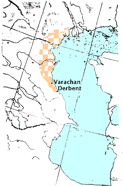 Huns called their territory “Huns land”, “Our
Country” (Movses Kalankatuatsi 2, p. 200, 207-208), and the Huns Grand Prince Alp-Ilitver
calls her “my country” (Movses Kalankatuatsi 2, p. 132). The opinions of researchers in respect to the location of the Hun country in the 5th-7th centuries are generally unanimous, it is the Caspian Dagestan. But the judgments of the majority of the authors are not distinguished by geographical details, or by chronological phases in its territorial changes. The notions of the researchers are most general, the “Hun country” //64// was located north of Derbent (Bartold W.W. 1963, p. 670), in the Northern or Northeastern Dagestan (Artamonov M.I. 1936, p. 97-98; Fedorov Ya.S. 1972, p. 19, 22, 35, 39; Kuznetsov, V.A. 1984, p. 51; Gumilev. L.N. 1992, p. 51, 59), in the North Caucasus (Bernshtam A.N. 1951, p. 174), in Dagestan (Vernadsky G.V. 1992, p. 229). Some authors view the localization of the “Country of Huns” somewhat more specifically: littoral areas north-east of the main Caucasus range (Pigulevskaya N. 1941 p. 46), littoral areas (Artamonov M.I. 1962, p. 183; Klyashtorny S.G. 1984, p. 20), Maritime and Northern Dagestan (Dagestan History, 1987 p. 127). The localization of the “Country of the Huns” in the “History of the North Caucasus” in the
span between the modern city Makhachkala, and r. Ulluchai in the middle of the
Coastal Plain as very specific, but no justifications are given in support of that point of view (History of the North Caucasus. 1988,
p. 96 - 98). Only the opinion of two
authors, A. Gadlo and Yu.R. Jafarov, on the location of the “Country of Huns”
in our view is based on detailed analysis of written sources of information, with
parsing of information from the ancient authors in chronological order, but their views do not
agree. One has it as open space from the Lower Itil to Derbent (Jafarov Yu.R. 1985, p. 46, 62-63), the other has it as a local district in the Dagestan coastal plain and
foothills (Gadlo A.V. 1979, p. 152 .) Probably, the disarray in the opinions of researchers and their vague notions are caused not only by weak awareness of ancient authors about this subject, but also by the ethical motley of the Hunnic circle tribes in this region. In our opinion, the reason is in the methodology of the research analysis of the sources (The unspecified weakness in the allusion must relate to prejudices and partial blindness endemic to state-run scientists). |
||||||||||||||||||||||||||||||||||||||||||||||||||||||||||||||||||||||||||||||||||||||||||||||||||||||||||||||||||
|
3. POLITICAL CENTERS OF CASPIAN LITTORAL IN THE 8TH CENTURY. |
||||||||||||||||||||||||||||||||||||||||||||||||||||||||||||||||||||||||||||||||||||||||||||||||||||||||||||||||||
65 The period of greatest activity of the
“Country of Huns”in the Caspian littoral coincided with
the beginning of the Arab Caliphate advance to the Eastern N.Caucasus. The
researchers date the first appearance of the Arab troops at Derbent to the 642/643. From
that time begins a long period of the Arabs military campaigns in the Dagestan plains and mountains,
which lasted for almost a hundred years (Novoseltsev, A.P. 1990. pp. 173-190). The
main force leading the struggle of the Northeast Caucasus peoples against the
aggressive policies of the Arab Caliphate became the Khazar state. The main impact of the Arab
expansion might fell on the nations of the Dagestan Caspian littoral. This
region from the beginning of the 8th c. to 740s suffered almost continuous devastations, many
economic centers ceased to exist, bloody battles claimed tens of thousands of
lives, and the women and children, along with material loot, became war spoils for the Arab
fighters. In the Arab army was a special post of the “Custodian of Spoils” (“mukasim/mukhasim”,a Persian for ca. “adversary
(spoils)”). Sources testify that the resistance of the Dagestani peoples to the Arab aggression was strong and sustained. The struggle went on with varying success. The Arabs had to repeatedlyconquer the same Dagestan regions and cities. And as soon as the Arab power in the region slackened, the lands abandoned by the population were re-populated again. Only by the beginning of the 10th c. the Khazar-Arab relations stabilized, Derbent became a demarcation dividing spheres of influence of two states, the Arab Caliphate and the Khazar Kaganate, it strongly guarded by the Arabs (Novoseltsev, A.P. 1990, p. 191). In the 8th c. on the political map of the Caspian littoral, and on the Dagestan mountainous regions befell significant changes. Sources report the existence in this period in the Caspian littoral north of Derbent of several political entities: the “Country of Huns”- “Possession Samandar”,“Balanjar “Country”, “Territory Vabandar”,“Haidak Land”,“Khazar Country”. |
||||||||||||||||||||||||||||||||||||||||||||||||||||||||||||||||||||||||||||||||||||||||||||||||||||||||||||||||||
|
3.1 “HUN COUNTRY” — “POSSESSION SEMENDER” |
||||||||||||||||||||||||||||||||||||||||||||||||||||||||||||||||||||||||||||||||||||||||||||||||||||||||||||||||||
66 In the 8th c. the “Land of Huns”is mentioned by two Armenian historians - Ghevond and Stepanos Taronetsi. Vardapet Ghevond, writing in the late 8th c., indicates “that the military campaigns of
the Arabs in the period from 713 to 737 went on mainly in the “Country of Huns”(Ghevond. C 28, 81). In some cases he
also calls her the “Land of Huns” (Ghevond. pp. 72, 80). The author clearly distinguished political entities adjacent to the “Land of Huns”.They are called “Land of Maskuts”,, from the context of the source located south of the “Land of Huns”,and Derbent pass (Ghevond, p. 72). The Khazar territory is denoted by the author with a vague term - “Northern Countries” (Ghevond, p. 72). The Khazar territory unambiguously is located north of the “Land of Huns”,evidenced by the description of the Khazar troops route on a military campaign in the S.Caucasus (683? 730?): “... The commander with assembled army went through the land of the Huns, and through the Djor pass by the land of Maskuts, and forayed into the Paitakaran country” (Ghevond. pp. 71-72). This is further evidence that the sources not only in the 7th c., but also in the 8th c. clearly distinguished between the Caspian littoral “Land of Huns”,and the “Lands of Khazars” located in the immediate vicinity of the Hun possessions at their northern borders.
(Hewsen, Robert H. Armenia: A Historical Atlas. ISBN 978-0-226-33228-4 “Paitakaran doubtlessly was populated by ethnically non-Armenian population”) 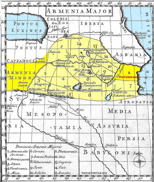 Ghevond does not specifically describe the location of the “Country of Huns”, but the
content of the text reveals that its southern borders started with Derbent pass or, in the author's
words, the “Caspian Gates”,“Chor Pass” and “Djor Pass” (Ghevond. pp. 27 - 28, 72). Ghevond does not name other geographical landmarks, although
for example one of
the stories in the Ghevond “History” allows to conclude that the “Hun city of Targu” was located at the “thickly” wooded outer spurs of the Caucasus mountains. To the “Cocos” (Tr. Kuu Kas) mountains fled the Arab commander Maslama
fleeing from the defeat after a failed //68//
seige of the city (Targu) in 713/714. (Ghevond, p. 28). In 737, another Arab leader
Marwan (Marwan) captured an unnamed city in the “Land of Huns” located on the sea coast
(Ghevond, p. 80). It is believed that that city could be the Huns country's capital city Varachan. About taking it by the Arab forces led by Marwan informs the Armenian historian of the 13th c. Vardan the Great. His message is succinct, the tragedy of the events is depicted in one sentence: “Marwan (Marwan) went on a campaign against Varachan - the city of the Huns, and returned from there victorious” (Vardan the Great p. 95). However, addressed below are other opinions about the unnamed city of Ghevond. Here it is important to note that Ghevond, writing in the wake of events of the Arab-Khazar war, in contrast with the Arab historians of the 9th - 10th cc. who were describing the same events (al-Kufi, at-Tabari), in the first half of the 8th c. localized in the Caspian littoral the “Land of Huns”,and its cities (I.e. long after the Caspian Huns accepted supremacy of Khazaria, and the appointment by Khazaria as a Hun's Elteber an alien from the Ashina dynasty, Armenians still called the Hun lands the “Land of Huns”,and not the “Land of Khazars”). The Armenian historian of the 11th c. Stepanos Taronetsi repeats Ghevond's information about the Huns in the Caspian littoral, connecting with them the defense of Derbent in the 713/714. (Stepanos Taronetsi p. 95). The writings of the Arab geographers and historians of the 9th - 10th cc. with general
information about the Caspian littoral of the 8th - 10th cc. do not mention the “Hun country”.However, under the staggering layers of information about major milestones of the
Arab-Khazar wars is still traceable the fate of its peoples even during
// 69// the Khazar supremacy, whose tributaries has become the country of the Huns.
Two Arab writers, Al-Kufi and at-Tabari, wrote in the early 10th c. They fairly in detail account on military operations in the Caucasus in the first half of the 8th c., their information overlaps with that of the Armenian historian Ghevond. Geographic information about the Caspian Dagestan in al-Kufi is rather vague; the author labels areas north of Derbent by various terms, as a rule, the “Khazar” possessions. The author employed some generic, non-specific notations: “Khazar side” and “his (Khazar) country” (al-Kufi.p. 17), or general abstract - “Khazar land”,denoting areas generally controlled by Khazars (al-Kufi, p. 41). In some instances in the al-Kufi book can be “discerned” the names of political entities located in the Caspian Dagestan. Al-Kufi refers to “countries” in alliance with Khazars. These political entities al-Kufi calls “godless countries”,they had kindred relation with the Khazar King, “were with him of the same faith and descent” (al-Kufi p. 21). Al-Kufi information attests that these “godless countries” had to participate in particularly important military operations, but upon their consent, which indicates their great political independence (al Kufi p. 22). To the “godless countries” //70// apparently belonged the “Country of Huns”of the Armenian sources, with its new capital Semender.
70
Al-Kufi mentions Semender repeatedly in describing military operations in the Caspian littoral (al-Kufi, p. 19-20, 41, 49). But he is not stating about Arabs taking this city by storm. In 722 The Arab commander Jarrah was planning a campaign against Samandar (Semender), after first conquering the lands subordinated to Khazars - the “Balanjar Country” and “territory Vabandar”,but having received a warning from the “possessor of Balanjar”,who became an Arab ally, of the impending upon him huge Khazar army, Jarrah quickly led his troops to beyond Derbent. During a campaign against the Khazars in the 727/728, the Arab commander Maslama entered several cities, abandoned without a fight by the Khazars, among them also was Samandar (This Scythian tactics survived to Modernity, it was used by the Türkic scion Kutuzov in the Franco-Russian War of 1812). The Arabs had to flee Samandar after learning of the enormous forces gathered against them by the Khazars (And the same happened to Darius in 512 BC and Napoleon who fled from Moscow in 1812). In the years 737/738 the Arab leader Marwan, with the campaign objective to capture
the capital of the “Khazar Kingdom” al-Baida (Itil)
on the Volga, first had to reach Samandar. He came
there by crossing the land of Alans, ravaging them. The author is silent on the storm of Samandar or
its willingness to
surrender to the Arabs. We only know that in the vicinity of Samandar
Marwan thoroughly prepared troops to march on al-Baida. The troops were reorganized, re-equipped
with new spears, re-dressed, apparently into special white robes, including everybody -
the military
commanders,
// 71// subordinates and servants (al-Kufi, p. 49).
The Marwan 150 thousand army set out from Samandar to al-Baida. The author does not say
another word about Semender. In general, al-Kufi's Semender remains in the shade, compared for example with another city Balanjar.
According to al-Kufi, the Arab major military operations in the Caspian littoral fell
on the “Land of Balanjar”.And if Balanjar serves at al-Kufi as “Land” or “Ruler of the Balanjar Country”,as a main city of the political entity, as will be
discusses in detail
below, the al-Kufi Samandar (Samandar) - is just another “one of the Khazar cities” (al-Kufi,
p. 49). But we know from other, earlier Armenian sources, that in the 7th c. the city Samandar was one of the largest cities in the “Country of Huns”, which was in alliance
with Khazars. Al-Kufi has no information about the “Country of Huns”. However, some
al-Kufi writings indirect evidence suggests that in the first half of the
8th c. Samandar was the principal city in the “Country of Huns”, after the
demise of
its former capital Varachan. The residence of the Hun Prince was transferred to Samandar, located in the inner, northern
part of the “Country of Huns”bordering on Khazaria. and according to al-Kufi in the first half of the 8th c. Samandar
appears to be more an ally of the Khazar King and the “Ruler of the Balanjar Country”,and not a
territory totally in the Khazar power. To the Samandar “flees” the Ruler of Balanjar after the capture of
his residence by the Arab
//72// commander Jarrah; Khazar King usually
assembled a
large force if Semender was threatened by the Arabs with capture. On one of the very large battle, probably in the realm of the “Country of Huns”, is relayed in one of the al-Kufi stories. In the 722/723 the Arab commander Jarrah, pursuing Khazar forces retreating under pressure of the Arabs and Azerbaijani troops, reached abandoned by the Khazars Derbent. 6 farsakhs (aka parasang = 5 3/4 km, about 42 km) north of the river Al-Ran broke the first battle between the Arab and Khazar forces, which ended in defeat for the Khazars (al-Kufi, p. 17-18). In the same campaign Jarrah took al-Hasin (probably a fortress) and a city Bar'ufa, besieged by the Arabs for 6 days. Apparently, the named fortified settlements also were located in the “Land of Huns”,because only after destruction of its possessions the Arabs passed to the “Balanjar lands”. A recital of these events is also in the composition of the Arab historian of the 13th c. Ibn al-Athir. But the names of some settlements occupied by Jarrah during the 722/723 campaign are transmitted by Ibn al-Athir somewhat differently than by al-Kufi (Ibn al-Athir, p.24). At-Tabari (also at-Tabari, 839 - 923) has some information
about Samandar in the first half of the 8th c. During the Arab commander Marwan campaign
of 737, organized to
capture the capital of the Khazar Kings on the river Volga (r. Siklab), the Arab
commander first leads his troops to Samandar (In this paragraph
the most interesting is the Arab name of Itil, different from the Türkic Itil and from
the Slavic Volga. Siklab is a rendition of the form sing. Saklab
About it also wrote Al-Kufi. But al-Kufi also did not explain why the Arabs set a goal to reach Samandar and why they did not take it. Al-Tabari in addition says that in the Samandar “...was living Hakan, the king of the Khazars, who hurried to leave town”,so Marwan went further, leaving Samandar in the rear, and sat a camp on the river Siklab and attacked the camp of the infidels...”.(at-Tabari. I p. 87). As can be seen from the quotation, city Samandar is defined as not only as ostensibly a Khazar city, but also as a capital, where was located a headquarters of the Khazar King. However, the depiction of the subsequent events in at-Tabari suggests that the capital city of the Khazars was a city on the river Siklab, because at-Tabari calls it “my (Khazar Khakan) city”.As a gratitude for accepting Islam, Marwan left the Hakan of Khazar a ruler in “his city”,despite the “brutal defeat inflicted on the Khazars” (at-Tabari. I, p. 87). The lodging on the Khazar King in the Samandar was probably temporary, and connected with overseeing military operations in the Caspian littoral against the Arab expansion. Thus, only of the Armenian historians, and mostly Ghevond, provide most lucid
evidence on the fate of the “Country of Huns”in the Caspian littoral during
Arab expansion in the Caucasus. This is understandable, for he wrote his work about 60
years after the described events. According to him, it was the “Country of Huns”
that first fell to the devastation brought over to the Caspian littoral by the Arab forces. The “Land of Huns” in the fight against the Arabs serves //74// as an ally of the Khazars, as one of the major forces in the Caspian littoral, able to withstand the onslaught of Arab expansion. At al-Kufi and at-Tabari, who wrote about 150 years after the events, details about Caspian Dagestan in the 8th c. are vague, their conveyance was apparently superimposed by the notions of the region from the following centuries. But they still have traceable fate of the of the “Country of Huns”. As demonstrates the comparative analysis of the Armenian and Arab sources, the “Country of Huns” of the Armenian authors and the Samandar of the Arab authors are identical concepts in the first half of the 8th c., they delineate the Caspian littoral area between cities Derbent and Samandar. On the northwest the “Country of Huns” bordered on “Balanjar country”, in all probability carved up from the possessions of the “Country of Huns”, addressed below. Its northern neighbor were the Khazar lands. As noted
A.V. Gadlo, the kingdom of Huns was the first to take on took blow of the Arab forces. In
his view, the clash with the Arabs weakened the the Hunnic confederation, and Khazars
took advantage of it (Gadlo A.V. 1979 p. 126) (Since the left
wing of the European Hunnic state joined the Türkic Kaganate in 560s, and remained
in the Kaganate till the dismemberment of the Western Türkic Kaganate in 660s, and
subsequently remained in the Khazar splinter of the Western Türkic Kaganate with a status
of constituent tribal union ruled by an appointed viceroy Elteber. Khazars had nothing to take
advantage of, and the A.V. Gadlo concept is hanging in thin air without any
foundation. The Huns, responsible for securing southern border of the states they
belonged to since 560s, suffered a debacle, their Elteber lost his position and probably
his life, and his functions were assumed by the central government, and for local matters
delegated to a new Elteber. The Caspian Huns received their first Elteber appointed by
the newly formed Khazar Kaganate in 660s, and the sequence of Eltebers ruled Huns till
the debacle of 737). Inclusion of the “Country of Huns”
territory into the forming Khazar state's sphere of influence occurred, as
rightly believes A.V. Gadlo, on the background of the Arab-Khazar war for the Caucasus (Gadlo
A.V. 1979, p. 153). In his study, A.V. Gadlo repeatedly emphasizes, and we concur with the
author, that the Huns of the “Country of Huns” led by Alp Ilitver can not be identified
with the Khazars //75// and Khazaria, because it is inconsistent with the evidence of the sources
(Gadlo
A.V. 1979, p. 139, Note 194, p. 141). M.I. Artamonov noted that Khazaria evolved
as a federation of tribes that even under supreme authority of the Khazar
Kagan have preserved their independence (Artamonov M.I. 1962, p. 184, 189). Gumilev also noted that the
Dagestan foothill and steppe areas were populated by non-Khazars (Gumilev, L.N. 1992 p.
48).
|
||||||||||||||||||||||||||||||||||||||||||||||||||||||||||||||||||||||||||||||||||||||||||||||||||||||||||||||||||
|
3.2 “BALANJAR COUNTRY” |
||||||||||||||||||||||||||||||||||||||||||||||||||||||||||||||||||||||||||||||||||||||||||||||||||||||||||||||||||
75 In the 8th c. on the political map of the Caspian
Dagestan of the Arab historians al-Kufi and at-Tabari is denoted the “Land of Balanjar”.
Apparently, under
the “Land of Balanjar” al-Kufi understands the remote Caucasian province of Khazaria. To
refer to it Al-Kufi also used other designations: the “land of Balanjar Ruler” or “Country of Balanjar Ruler” (al-Kufi. pp. 11, 19). Its main city was Balanjar, where was
located the residence of the ruler of the “Balanjar Land” (al-Kufi. pp. 10-11, 19, 20, 41, 47-48). The
Arab invasion of the the Caspian province of Khazars, the “Country of Balanjar
Ruler” raised a special
alarm of the Khazar King, forcing him to. undertake a large-scale retaliatory military
operation against the Arabs. On receiving the news of the Arab entry into the Balanjar
domain, the Khazar King sent envoys to all subordinated to Khazars countries to call
them to the war with the Arabs (al-Kufi. pp. 21, 41). Was assembled a great //76// army. Thus, in the battle for Balanjar in 652/653 against 10-thousand
Arab troops was staged a 300-thousand Khazar army (al-Kufi. pp. 10-11). After the Arab
commander Jarrah took Balanjar in 722, the Khazar King mobilized “a huge number of
Khazars”,and Jarrah had to flee (al-Kufi, p. 19-20). In yet another military campaign,
when Arab armies under command of Maslama again invaded the land of
Khazars - Balanjar, Samandar, and Vabandar, immediately upon receiving the news about capture
of Balanjar, Khazar King began gathering troops from the entire Khazar land, and soon was
on the march heading a vast multitude of the troops ( al-Kufi p. 41). The author notes, “So numerous were they that the Arabs were not able to resist”.The Arabs quickly
retreated to Derbent, gushing two day's march in a day. Another Arab leader Marwan in
735 took Balanjar and destroyed the “Country of the Khazars” (al-Kufi, p. 48). Two years
later, Marwan, assembling an unprecedented number of soldiers - 150 thousand
(usually in the Arab operations the in the Caspian littoral participated from 10
to 40 thousand soldiers) (al-Kufi. pp. 10-11, 18, 47), ventured on a successful offence
to capture the Khazar capital Al-Baida on the Itil. There, the Khazar King was able to
counter the
Arab forces with only 40 thousand of his soldiers (al-Kufi, p. 50). Topographic data on the country of the “Balanjar ruler” in al-Kufi is very scarce. It is known that within its territory is a fast river, with overgrown by dense forest //77// banks (al-Kufi, p. 10). The Balanjar apparently was located near Semender, its ruler fled there after the capture of Balanjar by Jarrah. The modern translation of the at-Tabari “History” from Arabic, in the description of the Arab military operations in the Caucasus, mentioned “own country of Türks” and “land of Türks” with a city Balanjar, which sometimes is simply called Balanjar (at-Tabari. II, p. 74). It is interesting to note that the 652/653 military operations in the Caspian Dagestan years are called by at-Tabari “Balanjar campaign”,the Caliph was personally appointing persons responsible for them (at-Tabari. II p. 75). In at-Tabari the “Balanjar Country” in some cases is denoted as “Khazar Country” or the “Khazar side” (at-Tabari. II pp.76-77). Exact identification of the location of the city (or country) Balanjar is impossible, although available indirect evidence in the at-Tabari book gives some idea about it. Some political entities conquered by the Arabs are located, by at-Tabari definition, “beyond the Balanjar mountains” (at-Tabari. II p. 79). Very important
is the message of at-Tabari that before foraying against Balanjar in 652/653 one of
the Arab commanders Salman ibn Rabia was appointed to control the Balanjar passes
(at-Tabari. II p. 75). Apparently the subject are passes on which paths stood the city Balanjar
(More logical to control passes to Balanjar. The
suggested site of Balanjar at modern Shura, Russian Buinaksk, 42.8°N 47.1°E, places it away from any passes). On the Balanjar location in the foothills also testify other facts. Speaking about the defeat of the Arabtroops at Balanjar in 653, at-Tabari reports some interesting details. On their retreat, the Arabs split into two groups, one of them went in the direction of al-Bab (In Arabic Bab بلد is akin to “country”,here: Derbent), and another by the “Khazar Country roads” and came to Jilan and Jurjan (southern coast of the Caspian Sea) (Gilan and Hyrcania/Gorgan respectively) (at-Tabari, II. C . 76-77). The first fraction was advancing to Derbent, apparently by the Caspian seashore road that ran through the non-Khazar-controlled territories, and therefore was more secure. As stresses the author, the choice of the road saved the Arab troop. The author has not disclosed the fate of the other Arab group, but perhaps considerable number of them perished, because the author contrasts these two decisions of the Arab military leaders on the retreat road, and the preference is given to the Caspian seashore road. Retreat by the Khazars' possessions, bypassing the Caspian seashore route, through the mountain passages, would have made it possible to reach the inner areas of the Arab-controlled territories. The Balanjar of at-Tabari, in all probability, was located aside from the Caspian coastal route, in the foothills on the way to the Caucasus passes. The closest western neighbor
of Balanjar was the “Country of al-Lan” (Alania), its towns and
fortresses “were behind Balanjar” (at-Tabari. II p. 78). Often, the Arabs
organized military forays against
Khazars from the territory of the Bab (In Arabic Bab بلد is akin to “country”) al-Lan, suggesting that “the Country of Türks” bordered directly on the “Country Alan”. Ibn al-Athir (13th c.) also writes about Balanjar, and it is known that his source is at-Tabari “History”.Indirect indicators of the author suggest that in most cases Ibn al-Athir with the toponym Balanjar was designating not the city, but the country.Like at-Tabari, he called some Arab military operations in the Caspian littoral “campaigns against Balanjar” (Ibn al-Athir. pp. 13-14). Very laconic information about the 8th c. Balanjar is given by two other Arab historians who wrote in the late 9th c., Al-Baladhuri and al-Yakubi. Al-Baladhuri called the areas north of Derbent with collective definitions: “side of the Khazars” or “Land of the Khazars” (al-Baladhuri, p. 16-19). He identified some geographic landmarks in the “Land of the Khazars”.These are the river Balanjar and the location of the grave of the legendary Arab commander Salman - Balanjar (al-Baladhuri, p. 14). Balanjar in the second case may be a battle-field or a valley where Salman died. The land belonging to the Khazar King the author called differently - “his (the Khazar King's) territory” (al-Baladhuri, p. 18). The author meant Khazaria with the capital on the river Itil. Al-Yakubi, who wrote his historical work shortly before
the death of al-Baladhuri (891), in describing the Arab military operations in the Caucasus
describes about the same milestones of the conquest of the mountain and Caspian littoral Dagestan
as
al-Baladhuri. But unlike him, al-Yakubi calls the territories where took place battles //80//
of the first third of the 8th c. “Türks' country” (al-Yakubi, p. 6-7), and only once
it denotes a “country belonging to the Khazars” (al-Yakubi, p. 7). Like al-Baladhuri,
al-Yakubi also does not give clear toponymic description for the “Country of
Türks” and cites
the same geographical landmarks that are mentioned by al-Baladhuri: Balanjar river and
so-called Balanjar (city and possibly country or region), which is comquered or submits to
the Arabs (al-Yakubi, p. 5-6). Balanjar as an independent political unit apparently split from of the “Country of Huns”. When that event occurred, and in what connection, the sources are unclear. And if in the late 7th c. the “Country of Huns” is “a kind of unified political entity, in the first half of the 8th c. on the Caspian littoral political map is found an independent “Possession Balanjar”,tightly connected with the Khazars, militarily, and possibly also by kinship. Balanjar was allied with the “Country of Huns” for joint defense against the Arabs.
M.I. Artamonov explains the secession of the “Balanjar Country” after the
destruction of the
Caspian Dagestan by the Arabs: in the region formed two separate political
entities. In the southern Caspian littoral formed the “Khamzin Country” with the main city Khamzin,
and in the
north formed “Possession Belenjer” with a capital Varachan and later Samandar (Artamonov M.I.
1962. pp. 228-229). A.V. Gadlo, unlike Artamonov, believes that Balanjar
formed as a separate ethnic entity and
political force before the first campaigns of the Arabs in the Caspian
Dagestan (653/654). After the defeat of 721/722, it lost its independence and
became a vassal of Khazars (Gadlo A.V. 1979. pp. 120-121), A. Gadlo localizes Balanjar in the steppes of Central
N.Caucasus, east of the Alan country and west of Semender (Gadlo A.V. 1979, p. 122). M.G. Magomedov
believes that the “Balanjar Country” covered a vast territory: the valleys of rivers Sulak, Aktas, and Yaryksu centered at Sulak (Magomedov,
M.G. 1983. pp. 28-36, 183).
|
||||||||||||||||||||||||||||||||||||||||||||||||||||||||||||||||||||||||||||||||||||||||||||||||||||||||||||||||||
|
3.3 VABANDAR LAND |
||||||||||||||||||||||||||||||||||||||||||||||||||||||||||||||||||||||||||||||||||||||||||||||||||||||||||||||||||
82 The sources have very little information about this political entity. It is first mentioned by al-Kufi in the description of the Arab military operation in the Caspian littoral in 722/723 headed by Jarrah. The author writes “After the capture of Balanjar, al-Jarrah led Muslim troops from the Balanjar lands and came to the territory of Vabandar. At that time it had 40 thousand homes” (al-Kufi, p. 19). Ibn al-Athir has a brief restatement of that event. He writes: “After Balanjar,
al-Jarrah encamped by the castle Olubandar (Olugbender) (Ulug bender = Great Cupola [of
the yurt]), which had about 40 thousand Türkic houses (families), and concluded a
peace treaty on terms of them paying a certain amount each year” (Ibn al-Athir p. 25)
(Ibn al-Athir gives the name of the city in the form Vbndr; that
agrees with the form in the Kagan Joseph letter, written in Hebrew alphabet).
The sources do not have other information on the Vabandar. Judging from the “number of families” in
the “Vabandar territory”,40 thousand, the country's population was about 300 thousand
people. According to A.V. Gadlo it was 200 - 250 thousand people (Gadlo A.V. 1979, p. 121). Based
on indirect evidence can be concluded that the Vabandar nearest neighbor was “Balanjar
Possession” to the east. A.V. Gadlo thought that Vabandar was one of the tribal
unions or a country. The author defines its location vaguely - deep in the North
Caucasus steppe (Gadlo A.V. 1979, p. 121).
|
||||||||||||||||||||||||||||||||||||||||||||||||||||||||||||||||||||||||||||||||||||||||||||||||||||||||||||||||||
|
3.4 “HAIDAK LAND” |
||||||||||||||||||||||||||||||||||||||||||||||||||||||||||||||||||||||||||||||||||||||||||||||||||||||||||||||||||
“Haidak Land” (Kaitak) (Kaitag) is first mentioned
by the Arab historian al-Kufi in connection
with military actions of the Arab commander Jarrah in the Caspian littoral in 722/723. Jarrah
decided to cunningly lure the Khazar troops, hunkered down in their country and apparently avoiding
an open encounter with the Arabs (al-Kufi, p. 17) (The
traditional nomadic tactics was to prepare an ambush and wait for the enemy to fall in
it). The main forces of the Arab army in a day secretly streaked from the
river Rubas through Derbent to
the river ar-Ran (ar-Ran was read erroneously < ar-Vak = Darvak/Darbak), and a large
3-thousand strong detachment the Arab commander secretly sent to Haidak. By the next morning this
detachment was to join the main force of the Arabs on the river ar-Ran
(Darbak). Jarrah thus
was faking the small size of his troops to draw Khazar forces into
a battle in a convenient place. Apparently, Haidak had allied relations with the Khazars,
because on receiving the news of the devastation produced by the Arabs in the Haidak, the Khazar //83//
troops immediately came to the river al-Ran (Darbak), where
a 25-thousand Arab army was already waiting for them. And despite the fact that the Khazar army numbered
40 thousand men, apparently the effect of surprise played its role. The Khazars fled from
the battlefield. The exact localization of Haidak from the dwscriptions of al-Kufi is impossible. This political entity was located somewhere on the way to the battle at the river ar-Ran (Darvak/Darbak), located 6 farsakhs (~ 42 km) (north) of Derbent, i.e. at a distance of one day's march. A.P. Novoseltsev identifies p. ar-Ran with the modern river Ullucha (Tr. Great River, Türkic “chai” = river is allophonically identical to the Chinese “shui” = river, one of the two Chinese words for the river, and a good candidate for a Chinese borrowing from the Zhou language) or Ortozen (Novoseltsev, A.P. 1990. p 189) (Tr. “orto” = center, middle, i..e. Middle Zen). The same episode about Haidak, described by al-Kufi, also repeats Ibn al-Athir, without naming Haidak. Ibn al-Athir writes: “And he (Jarrah) entered the city (Derbent) and sent his cavalry against the neighboring tribes to rob and attack, and they took much booty and returned the next day” (Ibn al-Athir p. 24). The story of al-Kufi about Jarrah ravaging Kaitak is repeated in the “Book of Derbent” (Derbent-name. I,
p. 34; II. pp. 58-59; III. pp. 28-29). The details of the narrative are different - the annals
exaggerated the size of the Arab forces ravaging Kaitak, and the size of the booty captured there. The “Book of Derbent” mentions the 8th c. Haidak (Kaitak) in connection with two events, the conquest of Kaitak by Maslama in 733/734 and the Marwan attack on Kaitak in 737/738. The Arab sources do not mention //84// Haidak among political entities in Dagestan conquered by the Arabs in military campaigns of the 733/738. The Rumyantsev manuscript of the source describes the results of the 733/734 campaign as follows: “Then (Abu Muslama) went into Possession Kaitak. In battles and fights he had killed the brave Kaitak ruler. He captured Kaitak, converted to Islam most of the population, and assigned them an annual kharaj. Abu Muslim appointed as a ruler (of Kaitak) a man named Hamza (Hence, the name Hanzin) from among his people” (Derbend-name. Ш p 33). The annals define the location of Kaitak in the 8th c. as north of Tabarsaran (Tabasaran) and south of Tuman (Derbend-name. I, p. 29; II p. 45; III p. 21).
|
||||||||||||||||||||||||||||||||||||||||||||||||||||||||||||||||||||||||||||||||||||||||||||||||||||||||||||||||||
|
3.5 “KHAZAR COUNTRY” |
||||||||||||||||||||||||||||||||||||||||||||||||||||||||||||||||||||||||||||||||||||||||||||||||||||||||||||||||||
84 As was noted above, the areas north of Derbent
the Arab authors in the first half of the 8th c. often called “Khazar” possessions. The definition “Khazar lands” usually was a generalizing concept that referred to the territories that to a varying degrees were dependent on
the Khazars. So, in al-Kufi in one case the term “his (the Khazar King) country” applied to the Balanjar Possession (al-Kufi, p. 41). For example, the political entities
in the N.Caucasus (Balanjar and
Vabandar), to which settlements returned “Khazars” after a temporary slackening of the
Arab aggressive policies, are called by the author “their (Khazar) lands”.In another case
the “country of the Khazars” designated territories in the Caspian littoral //85//
newly regained by the Arabs (al-Kufi, p. 47). However, the terminology used by al-Kufi to denote Khazar possessions becomes more specific when the author describes events in the domain of the Khazar King with its capital at al-Baida. Al-Kufi calls it non-uniformly, but semantically always distinctly - “Country of Khazars”,“Khazaria”,“his (the Khazar King's) kingdom” (al-Kufi, p. 49-52, 69). Other Arab historians of the 8th c. also distinguish the “country of the Khazars” with its capital on the Itil from the “Khazar lands” in the Caspian littoral - al-Baladhuri and at-Tabari (al-Baladhuri, p. 18; at-Tabari. I p. 88). Ibn al-Athir also repeatedly refers to the “land of Khazars”.Sometimes this name is used as a collective designation for the Khazars and their allies' territories from among the inhabitants of the Caspian littoral (Ibn al-Athir, p. 23, 29), but in most cases it is used as a name for the main territory of Khazars (Khazaria) with the city al-Baida (Itil) on the Itil (Ibn al-Athir, p. 26, 31 - 32). The sources do not delineate clear boundaries of the the 8th c. “Khazar Country”. Her
southern boundary adjoined the “Samandar possession” (Makhachkala) in the
Caspian littoral. As was noted above, some researchers believe that the North-Eastern Caucasia fell into political dependence on Khazaria only in 660's, when the Arabs devastating campaigns in the region weakened the “Country of Huns”, which took upon the first attack //86// of the Arab aggression. L.N. Gumilev believed that the Khazar domain territory from the 2nd c. AD was in the lower courses of the Terek and Sulak rivers, later in the 3rd - 4th centuries Khazars moved along the coast to the mouth of the Itil (Gumilev L.N. 1992 p. 38). By the early 9th c. Khazaria, subjecting many people, expanded its borders. Her possession, according to Gumilev, were limited in the west by the r. Don, in the south they reached the Caucasus and Yayla, in the east they reached r. Yaik (Gumilev L.N. 1992 p. 62). from the Eastern Wing of their confederation
According to A.V. Gadlo, the most ancient territory of Khazars, the core of the Khazar Confederation, were the modern black soils of Kalmykia (Gadlo A.V. 1979 p. 186). According to S.A. Pletneva, the Khazar federation by the beginning of the 8th c. occupied steppes and foothills of Dagestan, the r. Kuban basin, the Azov steppes, and most of the Crimea (Pletneva S.A.1986 p. 23). 
Khazar Kagan royal domain A.P. Novoseltsev believes that the Khazar homeland was in Eastern Caucasia. In the 7th c. they settled at the mouth of the Volga, and then Khazar colonies were located in the Crimea and the Don basin. According to the researcher, “The Khazars in their state did not have a compact territory, and were “like islands in a world of cosmopolitan south-east Europe” (Novoseltsev, A.P. 1990, p. 112) (Very deep and timeless thought that applies to practically every ethnic group in practically every multi-ethnic country: Russia, China, USA, you name it. Apparently, the Novoseltsev's 1990 idea is to belittle the Türkic mother-country of Russia). |
||||||||||||||||||||||||||||||||||||||||||||||||||||||||||||||||||||||||||||||||||||||||||||||||||||||||||||||||||
|
3.6. Historical Geography |
||||||||||||||||||||||||||||||||||||||||||||||||||||||||||||||||||||||||||||||||||||||||||||||||||||||||||||||||||
86
Thus, for the 8th c. various sources record in the Caspian Dagestan at least five
political entities. Closest to Derbent was the “Country of Huns” or “Semender Possession”,at this time
located in the plains between Derbent and Semender (Makhachkala). Apparently, west of the “Country of Huns” in the foothills was the “Haidak Land”.In the steppe regions north of the “Land of Huns' stretched the Khazar possessions, and at the north-western frontiers of “Hunia” in the foothills was the “Balanjar Country”,in the west the “Balanjar Country” probably adjoined possession of Alania and “Vabandar Territory”.The Caspian political entities were in various relations with the Khazar state, as will be discussed below.
Thus, the territory of the “Land of Huns” in the Caspian littoral evolved historically. In the 2nd - 4th cc. the Hun possessions still are not clearly distinguished from the neighboring territories. The Hun tribes lived in the Caspian littoral from the mouth of Itil to the northern borders of the Caucasian Albania. Although the Derbent pass was at that time the southern boundary between the nomadic world of the Huns and the agricultural states of S.Caucasia, this boundary was completely permeable for the Hun troops, and at certain stages Huns also occupied the Caspian littoral space located south of the Caspian Gate.
In their own borders, the “Country of Huns” took shape as early as the 5th - 7th
cc. The Caspian lowlands bound on the west by forward spurs of the Caucasus mountains
(from Derbent to the modern Makhachkala), and the Derbent Pass - Caspian gate on the
southern fringe of their possessions in this period are closely associated with the Huns. But apparently, the steppes of western Caspian
littoral to the mouth of Itil also belonged to the Huns, //88//
although the
constantly changing political situation in the steppes in this period could also
affect the extent of the Hun possessions. However, until the mid-8th c. her main
territory in the Eastern N.Caucasus remained unchanged..
In the first half of the 8th c., probably after the destruction perpetrated by the Arabs in the Caspian Dagestan, its territory is divided into several separate holdings. That is the actual “Country of Huns” with the new capital Samandar; its possessions stretched at that time from Derbent to the modern Makhachkala. In its northern area broke off the “Balanjar Country” and the “Vabandar Territory”,located in the foothills of the Western Caspian littoral, and the steppes of the Western Caspian littoral controlled Khazars with the center in Itil. In the subsequent periods (9th-10th cc.) the “Country of Huns” is known as “Semender Country”,at that its borders time frequently change, mostly the southern border shifting northward. In the 10th c. the “Country of Huns” was completely absorbed by the adjacent polity, the “Haidak Kingdom” which possessions prior to the Ruses' (Vikings) predations in the Caspian littoral extended to the Semender in the north and to the Derbent in the south. In the second half of the 10th c. Haidak occupied only foothill areas adjacent to the Derbent possessions. In the mid-11th c. the deserted areas of the northern coastal plane began to revive anew, including rebuilding of the city Semender, and the Haidak possessions grew again. In the 12th c. Polovetses (i.e. Kipchaks) established their dominance in the Caspian littoral. |
||||||||||||||||||||||||||||||||||||||||||||||||||||||||||||||||||||||||||||||||||||||||||||||||||||||||||||||||||
| Book Contents | Chapters 1-2 | Chapters 3-5 | Chapters 6-8 | Chapters 9-11 |
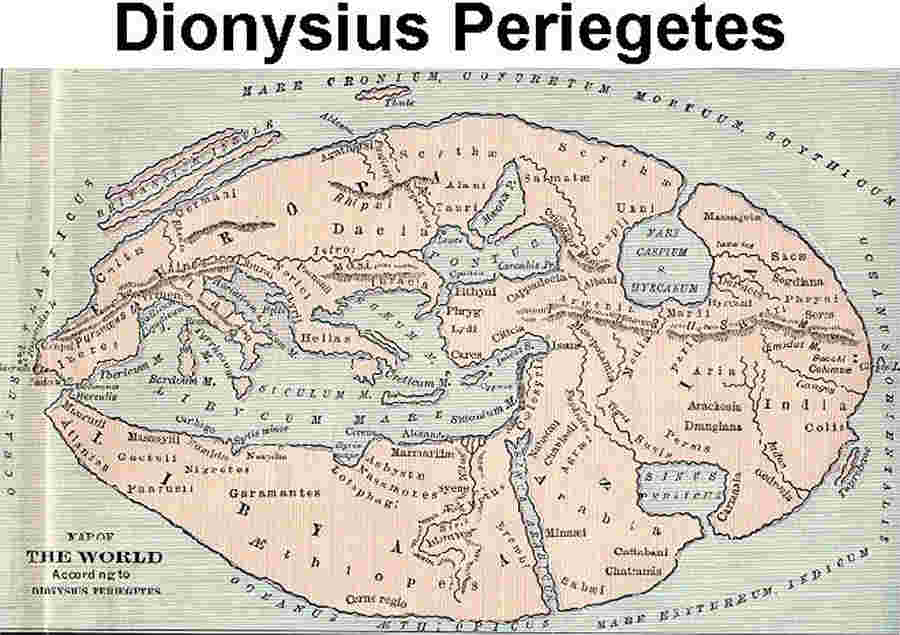
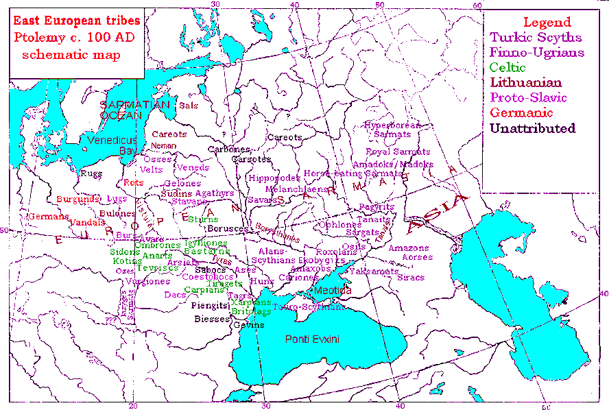
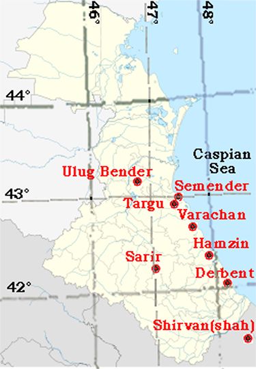
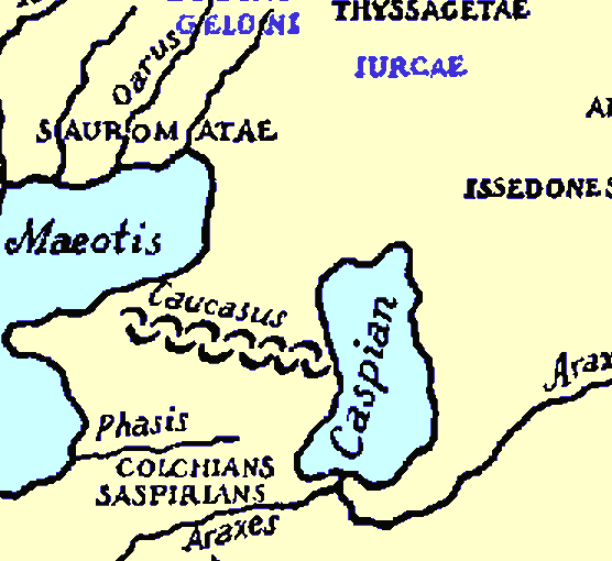
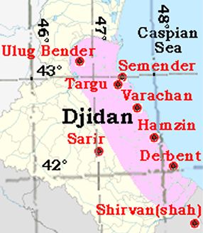

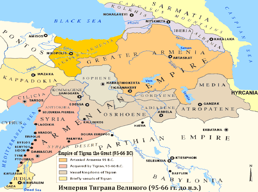
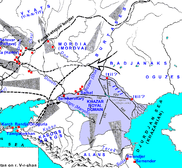
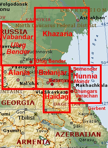