|
Russian version needs a translation
Mayak Citadel
|
|
Links
|
|
http://members.tripod.com/~Groznijat/p_bulgar/p_bulg8.htm
|
|
Summary
|
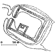
Mayak citadel
Mayak citadel is situated at the northern edge of the steppe, near the
forest-steppe belt.
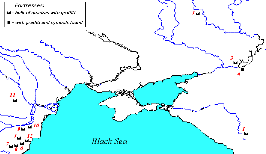
Fig. 1 Map of Bulgarian fortresses in Eastern Europe and
on Lower Danube, built of ashlar blocks and with inscriptions
1. Humarin 2. Cimlyansk Citadel (Right-bank) 3. Mayak Citadel 4. Sarkel
5. Pliska
6. Madara 7. Preslav 8. Han Krum 9. Silistra 10. Pyjkul luj Soare 11. Slon 12.
Devnja
|
The citadel ruins occupy a 80 m high hill, the promontory on the
lower inundated terrace of the river Tikhaja Sosna, at its confluence with
Don. The relative accessibility of the place required substantial additional
work on the fortifications, the neck of the promontory was cut off by a ditch
6 m deep and 12-13 m wide. The rectangular fortress (100 m by 85 m) was built
of regular ashlar blocks with dimensions 0.6 x 0.3 x 0.3 m, the same as in the
right-bank "Cimlyansk" citadel. The walls had no foundations, they
were laid directly on the leveled ground. The blocks formed two walls, the
inner space being filled with ir regular blocks and pebble. The total
thickness of the walls was 6 m, in places up to 7 m, with the height 6.0-6.5
m. The entrance was in the NW wall, guarded by a massive rectangular tower. An
inner rectangular fortification 42 m x 27 m, contiguous to the SW wall,
served as a residence for the local ruler.
Fig. 2 Scheme of the Mayak citadel.
To the east of the ruins is a large catacomb necropolis. The
characteristics of the burials (few artifacts, the predominance of single
burials, some differences in the structure of the dromos, etc.) link them with
the Bulgarian pit burials and, especially, with the Chiryurt catacombs.
Another peculiarity are the numerous signs and graffiti chiseled or scratched
on the limestone quadras of the fortification. Besides the drawings of horses,
donkeys, deer and other animals; scenes of a fight between a horseman and a
footman, etc., there are many symbolic signs - swastikas, pentagrams, crosses,
etc. as well as Türkic inscriptions. The drawings, the signs and the Türkic
inscriptions are absolutely similar to those from the danube Bulgaria and to the Nagy Saint
Miklos
treasure.
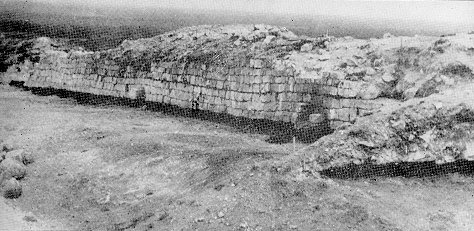
Fig. 3 Mayak citadel. Part of the inner side of the wall
with the typical ashlar blocks.
Right-bank "Cimlyansk" citadel
The right-bank "Cimlyansk" citadel is some 250 km north-east of
the mouth of Don. The fortress occupies a triangular promontory with steep
slopes and connected by a very narrow isthmus to the main plateau.
Fig. 3 Scheme of the right-bank "Cimlyansk" citadel
(accorfding to Pletnyova)
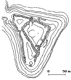
The 4 m thick stone wall consist of an inner and outer facings, built of
regular white ashlar blocks (dimensions 0.6 x 0.3 x 0.3 m), the space in
between was filled with smaller stones and pebble. One row of ashlars was laid
crossthwise, the next row - lengthwise, etc. The hight of the walls was 4
metres, and there were 5 towers, two of them guarding the isthmus, and other
two above the river Don. The inner space was inhabited, the dwellings were
light yurts or semi dug-outs. One yurt stands out with its dimensions, 6.5x5
m. It has three rooms, interpreted by Pletnyova as a male and female part and
a linking central room, and most probably it belonged to the local feudal, the
ruler of the fortress.
A suitable building material is not found locally, the nearest quarries
which could provide the necessary building material are some 100 km higher
along Don. The white fortresses high on the steep hill must have been an
impressive sight.
The excavations yielded abundant iron agricultural tools - sickles of
different types, light and heavy ploughshares, scythes, etc. Very interesting
are and iron vine sickles. This find in a fortress which is in the center of
one of the most important vine-growing regions in N. Pontic tells about the
early origin of the vine-growing in this region. The pottery is representative
for the Saltovo-Mayak culture, characteristical are the numerous cauldrons
with inner lugs.
The fortress was built during the final quarter of the 8th c. The end of
the right-bank "Cimlyansk" citadel is dated by the find of some 50
Sassanid and Arab coins from the first quarter of the 9th c. After the
destruction of the right-bank "Cimlyansk" citadel the Khazars built
another fortress, Sarkel, which became their stronghold in the region.
The right-bank "Cimlyansk" citadel was re-populated after the
debacle, but the fortress lost its military importance and was transformed
into a casual fishermen village. It was taken and destroyed again by the
Besenyos in the end of the 9th or in the beginning of the 10th c.
Sarkel
The Bulgarian presence was also attested in Sarkel, the principal Khazar
stronghold in the area. Sarkel, now under the waters of the Cimlyanskiy
reservoir, was built some 15 km east of the right-bank "Cimlyansk" citadel.
The excavations revealed that the Bulgars were main inhabitants of Sarkel
during the Khazar period, the drawings, signs and the inscriptions in Mayak
and Sarkel are very close, they also have counterparts in the quadras and
bricks with the first Bulgarian capital of Pliska. As in Danube Bulgaria, many
if the signs were scratched on the walls and handles of the pottery,
especially amphorae. The very name of Sarkel ("White house, White
fortress") does not fit to its red wall, built of bricks. Artamonov is
very convincing in saying that Sarkel, built after the destruction of the
white right-bank "Cimlyansk" citadel, which was probably called
Sarkel, on the other bank of the river, took the name of the predecessor.
The numerous runes and symbolic signs on the bricks of Sarkel are very
important having in mind the scarcity of such material in the right-bank
"Cimlyansk" citadel. The latter was virtually destroyed in 1744,
when its quadras were re-used by the Russian military.
|
References
|
|
S.A. Pletnyova, Ot kochevij k gorodam ..., p. 39. The Bulgar
character of the inhabitants of the fortress is confirmed by the anthropological
material from the burned dwellings, it belonged to brachycranic Europoids with
slight Mongoloid features - the characteristic features of the Zlivka Buglars.
M.I. Artamonov, Istorija khazar, s. 313-316;
V.V. Ginsburg. Antropologicheskij sostav naselenija Sarkela - Beloj vezhi i ego
proizhozhdenie. MIA, 109, 1963, p. 260 sl.
|
|
|